
|
|
Mountain/Rock |
|---|---|
|
|
38.50009°N / 109.2286°W |
|
|
Grand |
|
|
Hiking, Mountaineering, Skiing |
|
|
Spring, Summer, Fall, Winter |
|
|
11641 ft / 3548 m |
|
|
Overview
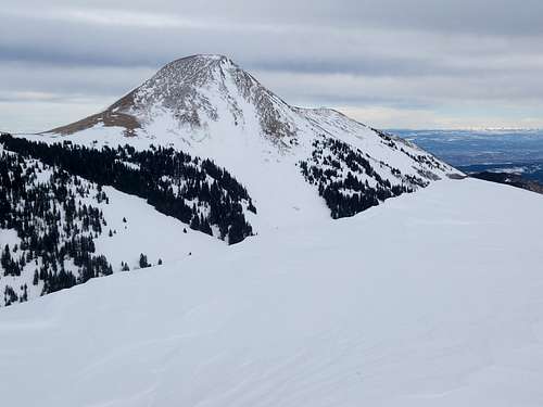
Burro Ridge is the name of the peak between Haystack Mountain and Manns Peak in the La Sal Mountains. It is much less known than its neighbors and Haystack and Manns Peak get a lot more attention. Interestingly the surveyed elevation for Haystack Mountain and Burro Ridge is exactly the same.
Burro Ridge probably gets more attention in winter and spring than it does in the other seasons due to its proximity to the Geyser Pass Yurt. A fair amount of people do ski the south face in winter and spring.
Of note, unfortunately the Pack Creek Fire of 2021 torched much of the area and the forest will take a long time to recover.
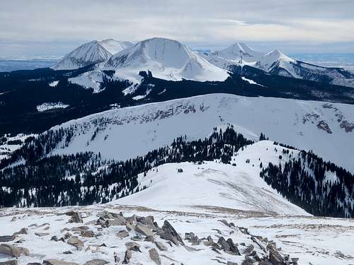
The peaks in the La Sal Mountains are often viewed, but realitively few people climb them (though this is changing and they are getting more popular as time goes on). They are the second highest mountain range in Utah, after the Uintas. They form the famous backdrop behind such famous areas as Arches National Park, Canyonlands, and Moab. Less famous, but just as spectacular it the view from the east and near Gateway Colorado. The La Sal means "The Salt" in Spanish and the mountains were named by the Dominguez/Escalante Expedition in 1776. There are two stories about the naming of the La Sals. The first is that they were named because the soils and valleys surrounding the mountains contain salt. The second is that since the Dominguez/Escalante party passed through the area in August, they just couldn't believe the mountains were covered with snow, so they assumed they were covered with salt as are some of the surrounding valleys. Since summer temperatures often soar to 110F or higher in the valleys, the story isn't as far-fetched as it may seem.
Getting There
Summer and Fall
From Moab, head south on US-191/Main Street and travel 7.8 miles. Turn left onto CR 127/Old Airport Rd (brown sign indicating Ken’s Lake and La Sals is located at the turn on US-191) and drive 0.6 miles. Turn right onto CR127/Forest Road 046 (La Sal Mountain Loop) and drive 11.5 miles. Turn right onto Forest Road 071 (Geyser Pass) and drive about 7.9 miles to Geyser Pass. Turn left (north here) and drive a short distance to the trailhead.
Winter and Spring
From Moab, head south on US-191/Main Street and drive 7.8 miles. Turn left onto CR 127/Old Airport Rd (brown sign indicating Ken’s Lake and La Sals is located at the turn on US-191) and drive 0.6 miles. Turn right onto CR 127/Forest Road 046 (La Sal Mountain Loop) and drive 11.5 miles. Turn right onto Forest Road 071 (Geyser Pass) and travel 4.5 miles. Park at the Winter Parking Lot.
Google maps has directions to Geyser Pass too, so you can just plug Geyser Pass into your phone and it will take you there.
Routes Overview
Burro Ridge via Geyser Pass
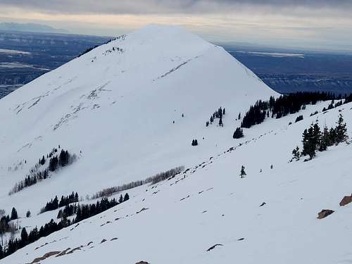
In all seasons, the easiest route is to follow the old road north from the trailhead and then head northwest to the saddle between Haystack Mountain and Burro Ridge. There is no real trail, but it's not difficult. Once on the ridge, follow it east to the summit of Burro Ridge.
In Summer, this route is only just over two miles each way (with about 1100 feet elevation gain) from the trailhead and should take only a few hours to half a day. In winter or spring, add 3.7 miles each way. If you want to climb more than just this one peak in winter or spring, I'd suggest an overnight stay at the Geyser Pass Yurt.
Burro Ridge via Oowah Lake
This is another possible route. From Oowah Lake, take the trail past Clark Lake and circle Haystack Mountain to join the Geyser Pass route above Geyser Pass. This route is just over 5 miles each way (with about 2800 feet elevation gain) and takes most of a day.
Burro Ridge via Burro Pass
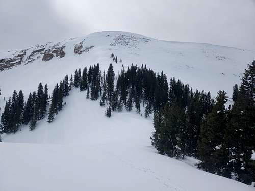
It is possible to climb Burro Ridge from Burro Pass to the north, but it's steep. In summer, there are no major problems, but if you are here in winter and spring only do this when conditions are stable since it's the perfect angle for an avalanche slope. In winter and spring take an ice axe and crampons for this route as well. I didn't and found the route to be sketchy at the top and I shouldn't have done it without my ice axe and crampons.
Burro Ridge via South Face
When conditions are stable, this direct route from Geyser Pass makes a quick snow climb in winter and spring. Only do this route when conditions are stable.
Red Tape
There is no real red tape other than the normal Forest Service rules, so please take care of the place.
When to Climb
This is a good objective year round, but in winter and spring, beware of potentional avalanche danger on the north and south face.
Summer type conditions usually start sometime in June and the snow usually returns sometime in October. Beware of thunderstorms in the summer.
Fall is a colorful season and is very beautiful in the area.
Camping
There are many campsites around the trailhead. The climb is a short one in summer and fall so it doesn't make too much sense to backpack.
In Winter and Spring most people stay in the Geyser Pass Yurt, which is a great place to stay, but you can snow camp in the area as well (which we did once, but decided to stay in the yurt the next time).
Mountain Conditions
LA SAL MOUNTAINS WEATHER FORECAST
Below is the climate summary for nearby Blue Mountain Ski Resort (no longer operating) at 9175 feet elevation, and in the nearby Abajo Mountains. These are all averages, so expect more variation, but this will give you a good idea about the climate at higher elevations in the area. The La Sals are typicially colder (due to higher elevations), wetter, and recieve quite a bit more snow than the Abajo Mountains, but this is the closest data available. *National Weather Service Data.
| MONTH | HIGH | LOW | PRECIP (in) | SNOWFALL (in) |
| JAN | 25 | 3 | 2.52 | 32.9 |
| FEB | 29 | 7 | 1.83 | 24.6 |
| MAR | 36 | 12 | 1.81 | 18.3 |
| APR | 47 | 19 | 1.51 | 5.5 |
| MAY | 57 | 27 | 1.86 | 1.0 |
| JUN | 68 | 34 | 0.91 | 0 |
| JUL | 74 | 42 | 3.08 | 0 |
| AUG | 70 | 40 | 3.51 | 0 |
| SEP | 63 | 32 | 2.14 | 0.5 |
| OCT | 52 | 23 | 3.00 | 2.1 |
| NOV | 37 | 12 | 1.98 | 11.5 |
| DEC | 28 | 5 | 2.60 | 27.4 |