
|
|
Route |
|---|---|
|
|
13.1567°S / 72.546°W |
|
|
Hiking |
|
|
A few days |
|
|
Hike |
|
|
Approach Overview
Generally everyone starts from Cuzco, Peru. Trekking the Camino Inca is a regulated and guided affair nowadays. The trailhead is easily accessed by rail or bus.At km 82 there is a small village where you are dropped off and begin your foot travel to Machu Picchu and then Huayna Picchu. Trekkers start by crossing the train tracks and soon the river. At the bridge your papers will be checked.
This is a 3 day approach. Total distance is 30+ kilometers. The trail all the way to Machu Picchu is good and of course routefinding is not necessary with your guide and porters. There is also no sense of isolation with the lines of wheezing gringos ahead and behind you.
Approach: Day 1

Day 1: From km 82 the Inca Trail follows the river for several kilometers before ascending. The hike is about 5+ hours. This is the shortest day. A large campsite at Huayllabamba (3.000 m) is available with an excellent overlook. On the way you pass your first set of Incan ruins available for exploration. Terraces far below are also visible.
Approach: Day 2

Break camp and begin the journey to Sayac Marca. This is the difficult day with a 1.000 meter ascent to Warmiwañusca or Dead Woman Pass (4.200 m). The views behind you are fantastic and framed by the deep V of the valley. Enjoy a deserved break at the top of the pass. Look sharp into the valley on the other side. It is possible to discern the trail down to the valley floor and then right back up the other side to a second pass. There is camping before and after the second pass. Many guided trips camp below at Pacaymayu which is nice after a big ascent but it is also crowded. Sayac Marca lies on the other side with the much more spectacular camping location. On the way up the second pass there is a small reconstructed tambo.
Hiking time to Pacaymayu is 6-7 hours.
Approach: Day 3
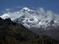
This day brings you two more major sets of ruins as well as your first glimpse of Huayna Picchu rising above Machu Picchu. This is a relatively easy day with excellent views.
Archaeological highlights include Conchamarca and Puyupatamarca and at the end of the day you descend through the terraces of Wiñaywayna.
Another established camp just beyond the terraces. This camp is kind of nasty. The overflow area beside the ruins is beautiful though.
Day 4: Machu Picchu and Huayna Picchu

Day 4: A pre-dawn start takes you through the Gate of the Sun, Intipunku, just before the sun breaks over the ridge and illuminates Huayna Picchu and the Hitching Post of the Sun in the Temple of the Sun far below in the ruins. This is where all the classic Machu Picchu photos are taken.
Descend from the overlook. You probabably need to check in at the entrance building before exploring further.
To climb Huayna Picchu proceed through the ruins towards the mountain. At the far end of the ruins are two roofed huts. Pass them and sign in at the small caretaker's booth. The trail from here on operates under more restrictive hours than the rest of the ruins so it is best to begin right away especially before the tourist buses arrive.
From the huts it is approximately 300 meters of steep "climbing" to the top. Some of this section requires your hands and can be dangerous when wet. You are rewarded with excellent views of the ruins, fat tourists staggering around far below, and even a small temple area complete with actual offerings of coca leaves still being placed.
Descent to Aguas Calientes
If your guided trip's services end at Machu Picchu you will need to get Aguas Calientes on your own. There are buses just outside the ruins but those are for weak tourists with dainty feet. Shoulder your backpack and walk the road down. Stay completely on the road (the only traffic are the scheduled buses) or take some of the steep local paths that cut the switchbacks. It is a pleasant walk.Cross the river and follow the road into Aguas Calientes. You are probably taking the tourist train back to Cusco and the tracks go right down the center of the main street so you can't miss them.
Walking time is only an hour or two.
Essential Gear
Guides and porters will carry most everything. All you need are your personal items including rainwear for 4 days.Machu Picchu and Huayna Picchu
