
-
 19914 Hits
-
 85.87% Score
-
 21 Votes
|
|
Canyon |
|---|---|
|
|
40.96849°N / 123.02353°W |
|
|
Hiking, Bouldering, Scrambling |
|
|
Spring, Summer, Fall |
|
|
Overview
Soaring, jagged summits tower over icy lakes in glacier polished granite cirques. Placid, azure creeks erupt into thunderous waterfalls. While this may bring the Sierra Nevada to mind, it describes the Trinity Alps's Canyon Creek. The core of the Trinity Alps is California’s other, lesser known but equally spectacular granite wonderland. Cutting into the heart of the Trinities, Canyon Creek brings all the best the Trinities have to offer in one easily accessible package. As one can surmise, the scenic bounty has not gone under the radar and it is far and away the most popular destination in the Trinity Alps. Nonetheless, crowds are still relatively light when compared to many parts of the Sierra. For those who desire solitude, it is still easily acquired in this spectacular mountain landscape.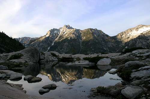 Sawtooth Peak from the Boulder Creek Lakes basin
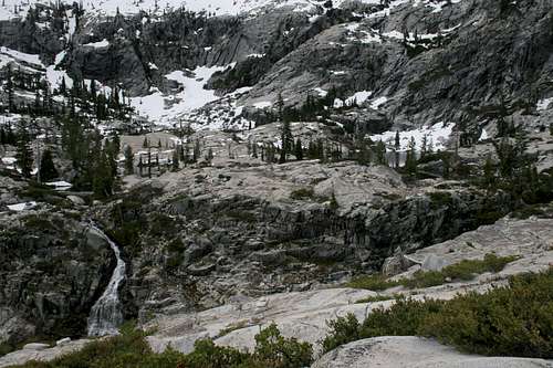
Canyon Creek ranges from 3,000 to 4,000 feet in depth. Four named summits over 8,500 feet tower above the canyon. Numerous other 8,000-plus and 7,000-plus peaks line the ridges. Three lake basins are located within the Canyon Creek drainage. Moreover, Canyon Creek itself drains the canyon. This creek is the real deal, a thunderous, torrential mountain river. Canyon Creek plunges over four waterfalls that even the Sierra would be proud to claim. Several other falls are located on feeder creeks, notably Boulder Creek. A seemingly limitless number of cascades pour down the walls of Canyon Creek. Throw in fantastic old growth forests, lush meadows and enormous granite boulders to flesh out the classic mountain dreamland.
Hiking and backpacking are definitely the most popular activity in Canyon Creek. The various Canyon Creek falls and the Canyon Creek Lakes are the most popular destinations in Canyon Creek. For those wishing to ditch the crowds, the Boulder Creek Lakes basin is the best destination. Although climbing is not nearly as popular in Canyon Creek, the possibilities for fantastic climbs on excellent granite are virtually unlimited. Most climbing takes place when summiting the peaks, but climbers have been spotted in other parts of the Canyon, especially in the Boulder Creek Lakes area.
Geography
 Boulder Creek Lakes Basin
The Trinity Alps are located in one of the great, forgotten mountain ranges of the American west. Ask people about the
 Middle Canyon Creek Falls
Aside from Mount Eddy, the Trinity Alps are the highest range in the Klamath Mountains. The Trinities themselves can be divided into three distinct regions. In the west are the vast Green Trinities. This area is composed of steep canyons, roaring rivers, sharp ridgelines, and utter solitude. The "green" appellation is derived from the vast stands of virgin timber found in this area. In the east, rising above Trinity Lake, are the Red Trinities. The name comes from the color of the serpentine that composes most of the mountains in this section. Numerous excellent peaks over 8,000 feet as well as an enviable number of lake basins are found in the Red Trinities. Sandwiched between these two attractive regions is the heart of the Trinity Alps, the White Trinities. So-called because of the stark, white granite found in this area, this is the home of the range's highest peaks, largest lakes and most spectacular mountain scenery. It is because of this region that the Trinity Mountains are justly elevated to the Trinity Alps.
Canyon Creek cuts into the heart of the White Trinities. Its headwaters are found in the Canyon Creek Lakes. It flows nearly twenty miles to the south before it joins the Trinity River at Junction City. Although the creek flows through an impressive canyon for its entire duration, the Canyon itself legitimately begins at the confluence of Canyon and Bear Creeks. The road into the canyon ends a short distance from this point, where the trailhead is located. The Canyon itself can be divided into two parts, Upper and Lower Canyon Creek. The Lower section is a steep, V-shaped canyon. Access to the creek can be difficult in sections. McCay Camp, a large island in the creek, provides the best route to the creek in the lower canyon. The Sinks, a stretch of creek that runs underground when water levels are low, are also nearby. The Upper Canyon is a classic U-shaped glacial canyon with sheer walls and a broad flat floor. Access to the creek is easy in this section and it is here that the high peaks and granite cliffs are most spectacular.
Four named peaks crown Canyon Creek, all of which are excellent climbing destinations. Thompson Peak, the second highest summit in the Klamath Mountains (after Mount Eddy), sits regally at the northern end of the canyon, forming an impressive backdrop to the Canyon Creek Lakes. Just below Thompson Peak sits the oddly named Wedding Cake, another impressive peak. Mt. Hilton, the second highest peak in the Trinities, towers above the Boulder Creek Lakes, an area that also provides the best views of Sawtooth Peak. As noted previously, several other 8,000-plus and 7,000-plus peaks are found along Canyon Creek.
History
 Canyon Creek from the Boulder Lakes
The Wintun Indians originally settled the Trinity Alps region. In the early nineteenth century American explorers began to encroach. The famous mountain man Jedidiah Smith passed through the region during his traverse of the western coast of North America. A few years later The Reading Expedition explored the region. Major Reading incorrectly thought the Trinity River flowed to Trinidad on the coast, thus giving the river its name. In truth, the river flows into the Klamath River near the present day Yurok Indian Reservation.
Gold was discovered in 1848 and hordes of prospectors soon poured into the region. Weaverville sprang up quickly and was soon the base of operations for gold miners. Settlements were established deep in what is now the Trinity Alps Wilderness. Evidence of this history can be found in many places, including Canyon Creek. McCay Camp was originally a miner’s camp. In the upper canyon, just below the outlet falls of Lower Canyon Creek Lake, several large iron pipes can be seen in the creek. These are the remains of the nineteenth century Stonehouse mining operation. Even greater evidence of this past can be found in other parts of the Trinity Alps, such as Papoose Lake.
Logging began late in the area. Consequently, most of the Trinity Alps consist of virgin timber. This is particularly dramatic in the Green Trinities, but Canyon Creek also boasts some enormous old growth trees. Logging in the Trinity Alps was permanently prohibited when the area was designated the Salmon-Trinity Alps Primitive Area. It was designated wilderness by the 1984 California Wilderness Act.
Peaks
 Sawtooth Peak
 Peaks 8,215 (L) and 8,090 (R) above Canyon Creek
The four named peaks surrounding Canyon Creek compose the ceiling of the Trinity Alps.
Thompson Peak (9,002):
The highest peak in the Trinity Alps and second highest in the Klamath Mountains, Thompson Peak is the Monarch of Canyon Creek. The view of the peak soaring above the Canyon Creek Lakes is one not easily left behind. It is possible to climb the peak from Canyon Creek, although access is much better from Grizzly Lake.
Mount Hilton (8,964):
Looming above the Boulder Creek Lakes basin, Mount Hilton is the dominant peak above the cirque. The second highest summit in the Trinities, it sees far fewer climbers than Thompson. Access is from the Boulder Creek Lakes. No established routes exist, although the nearly the entire route is visible from the lakes, since there is little tree cover and it generally climbs naked granite.
Sawtooth Peak (8,886):
The jagged summit is visible from numerous places inside Canyon Creek, but the peak rises so sharply from the canyon floor it is difficult to discern its immensity from most locations. The best place to gain an appreciation of Sawtooth Peak is from the Boulder Creek Lakes basin. From this location it is possible to see the peak rising dramatically from the bottom of Canyon Creek with impressive vertical relief. The summit can be reached from Smith Lake, which sits astride the ridge separating Canyon Creek from the Stuart Fork of the Trinity River. Smith Lake can be reached from either drainage, although the best route is from Alpine Lake. Alpine Lake is accessed via the Stuart Fork trail or the Bear Creek Trail, which leaves from the Canyon Creek Trailhead.
Wedding Cake (8,569):
Wedding Cake is situated just below Thompson Peak, on the ridge separating the Grizzly Creek drainage from the Canyon Creek drainage. The peak is a sharp pinnacle of granite, jutting up dramatically from the ridgeline. Although 450 feet shorter than Thompson Peak, the two summits appear to be twins from the Canyon Creek Lakes basin. Wedding Cake is accessed along the same lines as Thompson Peak.
 Upper Rush Creek Lake from Monument Peak
Monument Peak (7,771):
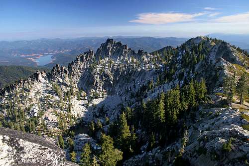
Monument Peak anchors the southern stretch of Canyon Creek. The mountain is essentially a massive granite ridgeline with a prominent summit knob. It is one of the few high peaks of the Trinity Alps visible from Weaverville. Monument Peak is not part of the core of the Canyon Creek area but it deserves inclusion since it towers high above the creek and is briefly visible from the road leading to the trailhead. The best place to observe the spectacular north wall is from the high peaks in the Red Trinity Alps, especially Red Mountain, or from the Stoney Ridge trail. Two lake basins are found nestled in Monument Peak. Beautiful East Fork Lake is accessed from Canyon Creek and sees minimal use. The four Rush Creek Lakes are found in an incredible granite cirque directly beneath the summit. These lakes are accessed by two different routes, both of which originate on the east side of the mountain and therefore are not part of the Canyon Creek drainage. The summit is an off trail scramble, but is one of the more accessible peaks in the Trinity Alps. Monument Peak also has what may be the best view in northern California. From the summit the canyon of Canyon Creek is so close one can almost reach out and touch it. The Green Trinities, Stuart Fork of the Trinity River, the Red Trinities, Mt. Shasta, Crater Peak, Lassen Peak, Brokeoff Mountain, the northern Sierra Nevada and the North Coast Range are all visible.
Unnamed Peaks
Numerous unnamed peaks, several over 8,000 feet, are located along Canyon Creek. Little information is available on these fantastic granite summits, but they appear to be well worth some exploration.
Lakes
 Lower Canyon Creek Lake
 Sawtooth Peak viewed from Boulder Creek Lake
Three lake basins are found in the Trinity Alps.
Canyon Creek Lakes:
The Canyon Creek Lakes are the most popular destination in the Trinity Alps. When standing on the shores of the lakes, taking in the Wedding Cake and Thompson Peak, with Sawtooth Peak towering overhead, the thunder of outlet falls and numerous cascades pouring into the lakes and granite cliffs rising up all around, it is easy understand the attraction. Factor in a relatively easy 8-mile hike from the trailhead, and the popularity of the Canyon Creek Lakes is ensured. Even so, crowds are small relative to many parts of the Sierra. Lower Canyon Creek Lake is 14 acres and sits at 5,600 feet. Upper Canyon Creek Lake is 25 acres and sits spectacularly at 6,000 feet. The views of Thompson Peak and Wedding Cake are spectacular. While the lower lake is entirely within a granite bowl, the upper lake does have a nice meadow on its north side. Adjacent to the meadow are sheer granite cliffs several hundred feet high plunging directly into the water.
Two more lakes are situated above the Canyon Creek Lakes. El Lake is located in the upper drainage northeast of Upper Canyon Creek Lake. No official trail leads to the lake, but it is an easy off trail trip up to 7,000', where the lake is nestled into a small cirque below Sawtooth Peak. Kalmia Lake is on a shelf above the headwaters of Canyon Creek, northwest of Upper Canyon Creek Lake. Access is difficult and follows a gully northwest of El Lake.
Boulder Creek Lakes:
While the rest of Canyon Creek may be awash with backpackers, the Boulder Creek Lakes are an isolated, empty and absolutely spectacular destination. The lakes are situated in a granite bowl with numerous small tarns surrounding the lakes. Two impressive outlet falls drain the lakes; one cascades into the main branch of Boulder Creek while the other plunges over the western rim of the basin in a dramatic freefall several hundred feet high. Numerous cascades feed the lakes. Mount Hilton is accessible up the granite cliffs north of the lakes. The best views of Sawtooth Peak are found here. To reach the Boulder Creek Lakes, Canyon Creek must be forded just above the Middle Canyon Creek Falls. From there it is two miles to the lakes, and nearly 800 feet elevation gain, which comes all at once.
Forbidden Lakes:
These are often considered part of the Boulder Creek Lakes group, but they are sufficiently higher and isolated to be considered a separate lakes basin. Situated in a narrow cirque, the forbidding name of the lakes is appropriate, given their hidden nature. From the Boulder Creek Lakes, it is possible to discern the location of the cirque, but one can be forgiven for not thinking lakes were located there. To reach them, simply follow the ridge on the northwest side of Boulder Creek Lakes.
Waterfalls
 The Canyon Creek Falls
 Boulder Creek Cascades
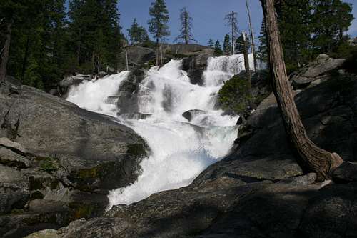
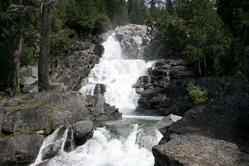
One of the best features of Canyon Creek is the waterfalls. There are four primary falls with numerous smaller falls and cascades.
The first fall on Canyon Creek forms the dividing line between the upper and lower canyon. This is THE Canyon Creek Falls. The trail used to pass near the base of the falls but the Forest Service rerouted it above the falls. Now the route offers only fleeting and partially obscured views of the massive waterfall. For those willing to do a little bushwhacking and are observant enough to find the route, it is possible to climb down to the base. The views are spectacular and the volume of water is daunting. In the past, when the trail passed by the falls, it was referred to as Lower Canyon Creek Falls. Once the trail was rerouted the waterfall fell into relative obscurity and the name was mistakenly applied to a significant cataract just above the real falls. The misnamed cataract is visible where the trail rejoins the Canyon Creek.
The Middle Canyon Creek Falls is the most impressive falls visible from the Canyon Creek Trail. The trail itself veers away from the falls leaving it partially obscured by trees, but a use trail leads to its base. It is possible to climb over the granite to the top and then rejoin the trail at the Boulder Creek Lakes trail ford. The falls is wide, with three channels pouring over the granite rim before rejoining in a swirling pool and pouring through another narrow slot.
Upper Canyon Creek Falls is located just beneath the outlet of Lower Canyon Creek Lake. A striking granite pinnacle can be seen high above the falls. The outlet of Lower Canyon Creek Lake also forms an impressive Cascade. The main channel tumbles down a narrow slot while numerous side channels funnel the water over a series of chutes and cataracts.
Several cascades fall down the sides of Canyon Creek. One of the best is located on the west slope of the Lower Canyon. It is best visible when the trail (which is on the east side of Canyon Creek) passes a small meadow. Other cascades are seen throughout the canyon.
The Boulder Creek Lakes basin has numerous cascades and falls. The outlet falls of the lakes are impressive as are the falls at the convergence of the creek from Forbidden Lakes and the cascades coming off Mount Hilton.
Getting There
 Upper Canyon Creek Falls
From Weaverville, head west 8 miles on Highway 299. At Junction City veer right onto Canyon Creek Road. Drive north 12 miles on the winding, narrow road. Park at the trailhead.
Weaverville can be reached from Eureka or Redding on Highway 299.
Red Tape
 Boulder Creek Lake inlet falls
Canyon Creek is located in the Trinity Alps Wilderness. Normal wilderness rules and ethics apply. A campfire permit is required by the forest service. No campfires are permitted in the Boulder Creek drainage.
Shasta-Trinity National Forest
3644 Avtech Parkway
Redding, CA 96002
(530)226-2500
Weaverville Ranger Station
P.O. Box 1190
360 Main Street
Weaverville, CA 96093
(530) 623-2121
Camping
 Boulder Creek Lake
Camping is available at the National Forest Service’s Ripstein Campground. There is no fee at this campground.
There are numerous campsites in Canyon Creek. The only good site in the Lower Canyon is McCay Camp. Excellent sites are found consistently once the misnamed Lower Falls is passed. Sites are found throughout the canyon all the way to the Canyon Creek Lakes. There are no good places to camp between the Canyon Creek ford and Boulder Creek Lakes, but there are several spots around the lakes themselves.