
-
 69863 Hits
-
 89.76% Score
-
 30 Votes
|
|
Route |
|---|---|
|
|
40.97264°N / 123.02422°W |
|
|
Hiking, Scrambling |
|
|
Spring, Summer, Fall, Winter |
|
|
Overview
 Thompson Peak and Upper Canyon Creek Lake
Canyon Creek is one of the premier destinations of the Trinity Alps. The soaring, jagged granite peaks, icy cold lakes, meadows, old growth forests and fantastic waterfalls all combine to form a quintessential mountain wilderness. It comes as no surprise then, that this is the most popular trail in the Trinity Alps. This is compounded by an easily accessed trailhead and relative proximity to civilization. Nonetheless, this should not deter wilderness seekers from making the trip into Canyon Creek for three reasons. First, the canyon is large enough to absorb numerous people and still retain a great deal of solitude. Furthermore, most of the people who enter the canyon remain in the upper canyon, between Lower Canyon Creek Falls and Lower Canyon Creek Lake. Most of the best destinations, such as Boulder Creek Lakes, El and Kalmia Lakes, Wedding Cake, and Sawtooth Peak, remain beyond the limits of most sojourners in Canyon Creek. Lastly, the number of excellent peaks to climb, lakes to visit and all-around jaw-droppingly gorgeous scenery to experience demand at least one visit, no matter how many people are camped out in the canyon. That being said, solitude and wilderness remain easily attained in Canyon Creek.
Getting There
From Weaverville, head west 8 miles on Highway 299. At Junction City veer right onto Canyon Creek Road. Drive north 12 miles on the winding, narrow road. Park at the trailhead.Weaverville can be reached from Eureka or Redding on Highway 299.
Route Description
It is notable during the approach to the trailhead that Canyon Creek is straight. What is seen along the road holds true in the wild part of the canyon. Once the creek plunges out of Lower Canyon Creek Lake, it heads south and does not deviate from its route. It is perhaps one of the straightest canyons found in wild America. It stands to reason then, that the Canyon Creek trail is a straight trail, deviating little from its northward trajectory. Looking into the maw of Canyon Creek
The trail begins at the Canyon Creek trailhead. The woods here are a mix of hardwoods and conifers. Oaks are dominant. Although there are granite boulders strewn about, there is little in the way of exposed stone. The trail travels north, on the east side of Canyon Creek. The creek itself can be heard, but not seen, since it is far below the trail. A short distance from the trailhead, the trail veers right and crosses Bear Creek. Stay to the left, off of the Bear Creek trail and climb out of the Bear Creek drainage. Soon the trail turns north again. The canopy is thick, but the west side of Canyon Creek is visible. The rock of the lower canyon is some type of metamorphic stone, but its sudden transition to granite in the upper elevations can be seen from here. A short distance from Bear Creek, a careful observer will spy an impressive falls cascading down the west side of Canyon Creek.
The east side of the canyon gets steeper as one progresses further into the canyon. There is still a paucity of exposed stone around the trail, although the hardwoods give way to ponderosa pines and incense cedars. At 2.5 miles from the trailhead, a short spur splits off to the west. This route leads down to a small island (called McKay Camp) in Canyon Creek. The island can be reached via a large log bridge over the creek. This is the first good campsite on the trail and roughly marks the end of the lower portion of the canyon. The Sinks, a rockslide covering the creek, are a short distance upstream from the island. During low water the creek disappears under the rocks, only to reappear a short distance away.
 Lower Canyon Creek
From McKay Camp the trail begins to switchback up the canyon wall. Until now, the trail had been fairly level. Nonetheless, the switchbacks are evenly graded and it is not steep. At the top of the switchback the trail begins to cross open granite for the first time. This is the first real view of the upper canyon. The views remain constant and impressive from this point on. This is also the only point on the trail with a reasonably clear view of Canyon Creek Falls.
A short digression is in order here. Canyon Creek is known for its waterfalls. It is generally understood to have three falls: Upper, Middle and Lower Canyon Creek Falls. However, at times in the past, the upper and middle cataracts went unnamed and only the lower falls was named. The USGS maps substantiate this, identifying the lower falls simply as Canyon Creek Falls. Of all the cataracts in the canyon, this is the most spectacular and was thus singled out. At one time, the trail even skirted the base of the falls, bringing hikers within close proximity of the waterfall. The trail has since been rerouted above the falls and it is only visible for a brief time at the top of the first switchback. Because of this, the other falls have increased in popularity and acquired their Upper and Middle monikers. Furthermore, there is an impressive cataract a short distance upstream from Canyon Creek Falls. This is often, though mistakenly, referred to as Lower Canyon Creek Falls. In summary, there is an Upper, Middle, and Lower Canyon Creek Falls, but the lower falls are originally THE Canyon Creek Falls.
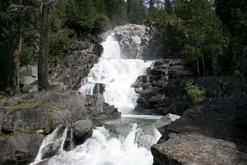 Lower Canyon Creek Falls
From the top of the first switchbacks, the trail continues to traverse the side of the canyon. Soon it crosses a stream and briefly doglegs to the west, 4 miles from the trailhead. Shortly after crossing the stream, a rough, unmaintained route heads southwest to the base of Lower Canyon Creek Falls. The route is hidden in the brush and may be hard to spot. Nonetheless, the view from the base is one of the most memorable parts of Canyon Creek and should not be missed. After the brief dogleg west, the trail turns north again and comes alongside Canyon Creek for the first time. Here one can stand on the cliff above the creek and observe the impressive cataract often mistaken for Lower Canyon Creek Falls. When the water is low, this is an excellent swimming hole. From this point on, the trail generally follows the creek closely and campsites abound throughout the canyon.
After the cataract, the trail generally continues north for several miles. About 0.5 miles from the falls, the route passes through Canyon Creek Meadows. The meadow is extensive, although most of it lies to the west of the trail and is often broken up by small pockets of trees. This tends to make the meadow appear as a series of smaller clearings rather than one continuous grassy area. After traveling through the meadow for a mile, the creek turns west, away from the trail. The trail continues northwest and begins switchbacking through a thick grove, traveling 0.5 miles before reaching the junction with the trail that leads to the Boulder Creek Lakes basin. However, this is not the preferred route. Once the creek begins to turn away from the trail, it is possible to follow it to the base of Middle Canyon Creek Falls. There is a faint use trail along the east bank of the creek, but it is not necessary to follow since the route is obvious.
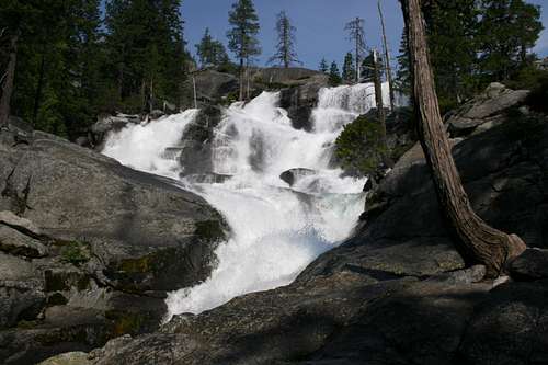 Middle Canyon Creek Falls
Middle Canyon Creek Falls is only slightly less impressive than Lower Canyon Creek Falls. The preferred route is to scramble up the small cliffs along the east side of the falls. Once reaching the top, one observes the narrow granite chute the creek passes through above the falls. Follow the creek upstream as it reenters the trees. Once here, one finds the trail leading to the Boulder Creek Lakes basin. To continue to those lakes, it is necessary to ford the creek. This should be done with caution at high water. This is also the preferred route to the summit of Mt. Hilton. To rejoin the Canyon Creek trail, simply follow the Boulder Creek Lakes trail away from the creek to where it rejoins the main trail.
Another side option here is to travel east, up a steep gulch to Smith and Morris Lakes, and ultimately, the summit of Sawtooth Peak. This is a difficult, trailless scramble. The gulch is reached by following a creek east from the Canyon Creek trail. This departs the trail at roughly the same point as the route to the base of Middle Canyon Creek Falls.
 Outlet falls of Lower Canyon Creek Lake
From the junction with the Boulder Creek Lakes trail, the Canyon Creek trail continues north another mile to another set of switchbacks. At the top of the switchbacks Upper Canyon Creek Falls becomes visible. An excellent campsite is found on an island at the base of the falls. Although not as spectacular as the two lower falls, Upper Canyon Creek Falls is still a prime cataract in its own right. Above the falls, the trail continues for almost a mile through another meadow. Things get a little dicey at this point. The trail originally stayed on the east side of the creek, climbing from the meadow up to the outlet of Lower Canyon Creek Lake. This route is still extant and apparent and people often mistakenly continue up this old trail. However, if one takes this path, it is necessary to ford the outlet of the lake in order to reach Upper Canyon Creek Lake. This is a dangerous proposition since the outlet flows directly into a series of impressive cataracts. Many people have lost their footing and died when they went over the ensuing falls. To avoid this, the trail has been rerouted across the creek, below the falls, and then up to the lake. Although the new trail is signed, the marker is not very visible. Instead, look faint trails leading to the west and a series of large iron pipes in the creek. These are remnants of a 19th century mining operation. A small community known as Stonehouse once existed on this site.
 Thompson Peak from Lower Canyon Creek Lake
Once across the creek, the trail all but disappears as it climbs a series of granite slabs up to the outlet of Lower Canyon Creek Lake. Cairns mark the way, although the route is obvious. The outlet of Lower Canyon Creek Lake is a massive cataract that tumbles over a series of granite slabs, forming a maze of waterfalls. Although the route bypasses the maze and goes directly to the lakes outlet, an entertaining routefinding exercise can be had trying to navigate the maze of swirling waters. From the outlet, the lake becomes visible and one of the great vistas of the Trinity Alps unfolds to the north. Thompson Peak, the highest point in the Trinities, towers 4,500 feet above the lake in true alpine splendor. Craggy Wedding Cake provides an appropriate companion. From here, the trail continues to skirt the lake and then makes a short climb up to Upper Canyon Creek Lake. The view from here is slightly better than from the lower lake. It is made more impressive by the sheer gothic wall that drops straight into the north end of the lake.
Once Upper Canyon Creek has been reached, numerous routes lead to a host of destinations. Seldom visited Kalmia and El Lakes lie to the north. Wedding Cake and Thompson Peak can be climbed by following one of the inlet creeks to the northwest. Sawtooth Peak can be climbed by following the route above El Lake. Mirror, Sapphire, and Emerald Lakes can also be reached from this point, although they are better reached by the Stuart Fork trail. All in all, this is one of the most sublime slices of northern California.
Maps
Canyon Creek Map
 Canyon Creek Trail
Upper Canyon Map
