Abort! Abort!
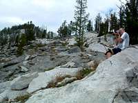
![Canyon Lake & Peak]() Canyon Peak sits high above Canyon Lake.
Canyon Peak sits high above Canyon Lake.
Elevation Gain – 4,200’ +
Ascent Date – 15aug06
Total Route Time – 6 hours 20 minutes
Ever since moving to the Bitterroot Valley
(from Indiana) during January of 2004, I’ve wanted to climb Canyon Peak. It just sits there over Hamilton, MT, looking inviting and irresistible.
![Canyon Creek Trailhead]() The trailhead boasts a nice new outhouse.
The trailhead boasts a nice new outhouse.
I found while talking to people who lived in the area that few even attempted to climb it. I heard talk from, “impossible” to, “it’s technical.” But, when I studied it on a Topo map, it just didn’t look all that bad. Steep? Yeah. Class 3 or 4 for sure, but not impossible.
So when my younger brother visited this year during the first couple of weeks August, we decided to give it a go. I found a description and route on SummitPost by Ben Johnson which provided what appeared to be sufficient information.
After several weeks of abnormally high temperatures, we got a break on the fifteenth and went for it. Since the daylight hours were still long and we’d estimated a total time of less than 10 hours, we didn’t leave the trailhead until 8:30 a.m., though it was still nice and cool.
![Approach to Canyon Peak North Ridge]() Our approach to the Canyon Peak north saddle.
Our approach to the Canyon Peak north saddle.
Unlike many of the trails leading into the Bitterroot Mountains, the Canyon Falls Trail is not super-steep for the first few miles. Sure the footing is uneven and the trail sees little in the way of maintenance, but the going was good, pretty easy, in fact.
Then
(yeah, there’s always a “then”) the trail got considerably steeper when it began working it’s way up the north wall of the canyon using, what some trail engineer must have thought were switchbacks.
Hah! As the “official” trail neared its zenith above Canyon Falls it finally gave our legs a break and leveled off. Once over the high point, a relatively quick descent dumped us out near Canyon Lake.
![Slabs & Talus]() We crossed granite slabs and talus during our approach.
We crossed granite slabs and talus during our approach.
Rather than proceeding all the way to Wyant Lake before beginning what looked to be a fairly steep ascent to the north saddle of Canyon Peak, we began working our way more gradually along a climbers’ trail leading upward from the south shore of Canyon Lake through the partially open forest. Obviously many others had had similar ideas about the best
(read, easier on the thighs) route to the peak’s north saddle.
The forest gradually opened up as we ascended. Our route took us over slab granite and small talus fields. Once we reached 7,800’ the views of the peak improved considerably and gave us a chance to study possible routes to the summit as we walked.
![High Lake from Saddle]() Hidden Lake is in the Blodget Creek Drainage.
Hidden Lake is in the Blodget Creek Drainage.
When we reached the saddle, 6.25 miles from the trailhead, we looked over and down at High Lake in the Blodgett Drainage. Wow! What a sudden precipice. The back
(west) face of the saddle dropped almost straight down. We turned to our left
(south) to look up at Canyon Peak , and discovered its west face was almost as steep. And, well, so was the east face. Yikes! This looked interesting, maybe too interesting. Talk about exposure…
It was time for a rest and some food. We dropped back off the saddle to some flat rocks and sat down to refuel. We talked about the chances for two(2) old geezers, aged 51 and 58, making this summit. Well, first things first. Time to put a little lubrication on those prone-to-blister spots on our feet.
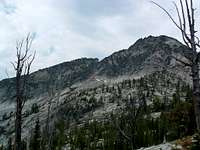
![North Ridge of Canyon Peak]() Canyon Peak's north ridge crest.
Canyon Peak's north ridge crest.
Half an hour later, we re-read Ben’s description. He suggested that, “Small patches of fairly steep grass wind up the NE side of the ridge. By heading toward small trees as we went up the ridge, my partner and I were able to replicate what appears to be a common route… Near the top of the peak, the ridge becomes very steep, and my partner and I found it easiest to traverse South
(directly under the peak) and ascend from there.” Maybe a little vague, but we thought we understood the basic concept and decided to give it a go.
As soon as we began, we realized it wouldn’t be possible to stay right on the ridge crest. The steps were just too big. We traversed from the crest of the north ridge a little way onto the east face where we had seen a possible ascent route. We started up. But before long ran into a section at 8,658’ which we could climb but were unsure of our ability to easily down-climb
(without equipment) should the need arise.
![Canyon Lake from Saddle]() Looking down at Canyon Lake from the north saddle.
Looking down at Canyon Lake from the north saddle.
Okay. We changed our location a bit for a better look at the higher sections of the climb before proceeding.
“Mmm… Yeah, we can do that section. That next part looks tough, but I think we can do that too. Uh oh! Look way up there, near the summit. I’m not so sure about that section. Do you see a way through it? No? Well. That’s it then.
“We’re stopping here,” I said. “We’re too old to be risking life and limb on a route we don’t feel comfortable with.”
![Possible SE Ridge Route]() Possible routes to the south ridge crest.
Possible routes to the south ridge crest.
Both of us hated to give up, so we traversed further onto the east face to what some might call the crest of an east ridge, looking all the while for other routes. It proved to be a bust. We couldn’t see anything better than the first route.
We got out Ben’s description again and re-read it, hoping we’d missed something. Somehow his ascent description seemed even more vague this time. Oh well. There’s always another day.
![North End of SE Canyon Peak Ridge]() This is the north end of Canyon Peak's southeast ridge.
This is the north end of Canyon Peak's southeast ridge.
Trying to salvage something from our aborted attempt, we decided descend the talus in a southerly direction so we could study the southeast ridge for possible ascent routes. Down-climbing east-southeast over the talus, we were pretty sure we could see two(2) ways up to the southeast ridge crest. One looked a little easier than the other and held our attention as we continued downward.
Exiting the talus, we arrived on top of the cliff band we knew we’d been heading toward. We moved left
(north) to easier going and continued toward the now, mostly-dry Wyant Lake. We walked across the mud flats of the lake toward the outlet falls, where we had our best look at the route we thought looked good for an ascent to the southeast ridge crest.
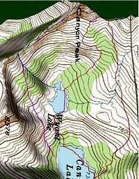
![3D Topo of Summit Attempt]() 3D Topo of our attempt plus 2 possible routes.
3D Topo of our attempt plus 2 possible routes.
It was time for a look at Ben’s descent description to see if he used the route we thought held promise. He stated, “The easiest non-rappel descent seems to be down the west face, traversing around the SW ridge, and following the lower portion of the SE ridge down to where it becomes a relatively easy descent down to Wyant Lake. It involved a bit of tricky route finding, but provided the safest way down with no technical gear.”
We weren’t sure which part of his descent route required the “tricky route finding”, but assumed it was the portion which stated “down the west face, traversing around the SW ridge.” At any rate, when he described “following the lower portion of the SE ridge down to where it becomes a relatively easy descent down to Wyant Lake”, we decided he was referring to the same place we were studying for a future ascent. Now, if we could just figure out what he meant by “tricky route finding.”
![Canyon Peak Profile]() The profile of our attempt.
The profile of our attempt.
Our down-climb along the stream from the Wyant Lake Falls to Canyon Lake was uneventful. We hiked across the late-season mud flats along the northwest edge of Canyon Lake and rejoined the trail we’d left several hours before.
For some reason, the hike from that spot back to the truck seemed to take longer than the hike in
(it didn’t), but then, isn’t that always the case?


Comments
Post a Comment