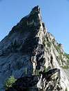
Overview
Canyon Peak sits back on the west side of the Bitterroot Valley above Hamilton. Only a few vantage points in town allow one to view Canyon Peaks and its appearingly sheer walls. The peak itself is above Canyon Lake and Wyant Lake at the end of the Canyon Creek. After about an eight mile approach on trail, the climb itself is 1500' of class three-four scrambling/climbing. Its North ridge divides Canyon and Blodget Creek drainages. From the top, one has breathtaking views straight down the steep faces of the peak.
Getting There
The peak is accessed from the Canyon Creek/Blodget Overlook Trailhead. From Hamilton (40 miles S. of Missoula), take Main Street west through town, and where it turns into Westbridge Road about two miles from Hwy 93, take a right onto Rickets Road. Take a left onto Canyon Creek Road after about .25 miles, and follow it until in turns to dirt and becomes Blodgett Camp Road. Blodgett Camp Road has a clearly marked fork, with the Canyon Creek trail to the left. The trailhead is another two miles.
From the trailhead, the base of the peak is about 8 miles on fairly steep trail. From the base above Wyant Lake, there are two options for climbing the peak. One can either hike up the alpine scree slope to the SE ridge, and ascend the peak via ridgeline, or hike up to the N. ridge, and ascend the peak in the same manner, by following the ridgeline. More in-depth route descriptions can be found in the "Routes" section.
Red Tape
No camping is allowed at the trailhead. Wilderness restrictions apply for most of the duration of the trail (the only pertainent one being no bikes on the trails).
When To Climb
As the majority of this mountain is a class three-four rock scramble, July-August is the best time to ascend the peak. An early spring or winter ascent would involve a very lenghty approach over snow. Usually, the trailhead is not accessible in the winter. Those with information of non-summer ascents feel free to contribute.
Camping
No camping is allowed at the trailhead, but plenty of decent campsites can be found at either Canyon or Wyant Lakes (six and eight miles from the trailhead)
Mountain Conditions
The Stevensville Ranger District will have the most up to date information on the weather and condition of the trail leading to the base of the peak. (406) 777-5461
If you have any more information...
Please feel free to contribute. All the info on this mountain comes from my personal experience and from one other person who has also climbed this mountain. I know many others have climbed it, but I don't have anyone else's beta. Thanks again to those who have submitted feedback in the comments section.

 29564 Hits
 84.01% Score
 18 Votes