
-
 4984 Hits
-
 89.77% Score
-
 30 Votes
|
|
Canyon |
|---|---|
|
|
36.28120°N / 116.7689°W |
|
|
Hiking, Bouldering, Scrambling |
|
|
Spring, Summer, Fall, Winter |
|
|
Overview
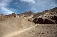
Of the many easily explored side canyons in the cliffs on the east side of Death Valley, one of the few with an official trailhead is Natural Bridge Canyon. A short walk up the stony streambed leads to a large natural bridge, one of several such features in the national park.The Canyon
From the trailhead walk east on the old dirt road towards the mouth of the canyon. You are walking along the top of an alluvial fan with beautiful deposits and cliffs with various shades of gray, tan, purple, white, and red.The trail turns a corner and heads up into the canyon. As you enter the canyon you are greeted with towering reddish cliffs formed from ancient alluvial materials. The 60- to 80-feet high wall on the north (left) side of the canyon is a hard conglomerate rock that shows bands of different-sized alluvial materials. If you trace the bands along the wall, you can see little faults and offsets where the rock fractured, slipped, and the bands no longer line up properly. The cliff on the south (right) side of the canyon is a softer alluvial material, and this side is not as steep or as high as the north side. Throughout this canyon, there are interesting colors and textures in the walls.
| Mouth of the Canyon | Natural Bridge | Dry Fall |
|---|---|---|
 |
 |
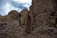 |
A few minutes up the trail, the canyon narrows to about 20 feet wide with vertical walls on both sides that are about 25 feet high. At this point, you can actually see the natural bridge farther up the canyon. After a total of about 10-15 minutes of walking in the canyon, you arrive at Natural Bridge. This arch is about 25 feet tall, 30 feet across, and 10 feet thick at the base. The top of the arch is even with top of the cliffs on the south side, but not as high as the wall on the north side.
Continuing up the canyon beyond Natural Bridge, you quickly come to a fairly thin, rocky fin that sticks out into canyon from the south wall. Just past the fin, there is an interesting pour-over in the south wall where the rock has eroded such that the pour-over is back in a narrow slot. A few minutes past the pour-over in the slot, you arrive at Cave Fault, which is on the north wall. Here, the rock has fractured and one side of the fault has eroded to form a cave.
A few minutes above Cave Fault, you get to a point where the canyon walls change from alluvial deposits to the metamorphic rocks that form the mountains that tower above Death Valley. Here, you can see that the alluvial deposits were laid down on top of the metamorphic "parent material" and that the forces of erosion have cut down through both of them. In places, you can see where alluvial deposits are stuck to the sides of the metamorphic canyon walls and haven't yet completely eroded away. In the metamorphic rock, which originally was sedimentary rock, you can see pretty swirls of blue, red, gray, and white, especially where the water has polished the rock.
The metamorphic rocks are harder than the alluvial materials, so they erode more slowly along the bottom of the wash, and shortly after getting into the metamorphic rocks, you arrive at two water-polished pour-overs. The two pour-overs involve a bit of scrambling, maybe climbing, and are fairly easy to get over, but the slick, water-polished rock is covered with dust and gravel, so watch your step. Above the second pour-over, a big boulder fell into canyon, and you have to crawl under it.
A few minutes after the boulder, you arrive at a 20 feet pour-over that blocks the trail. Enjoy the scenery, contemplate what it would be like with a flash flood blast through here, and then return to the trailhead by following your footprints in the gravel.