-
 11713 Hits
-
 86.37% Score
-
 22 Votes
|
|
Canyon |
|---|---|
|
|
36.39990°N / 116.7844°W |
|
|
Hiking, Scrambling, Canyoneering |
|
|
Spring, Summer, Fall, Winter |
|
|


Overview
Twenty Mule Team Canyon gets its name from the 20-mule teams (which actually consisted of 18 mules and 2 horses) that hauled 10-ton loads of borax and other ores on double wagons from remote, often inhospitable Death Valley out to market in the settlement of Mojave (CA) between 1883 and 1889. The image of the teams became romanticized and has persisted; today, it is the symbol of the U.S. borax industry. Borax, incidentally, was one of the few ores that ever made anyone much money in Death Valley. Prospectors came seeking a fortune in silver and gold, and the area experienced a vibrant boom-and-bust cycle, but it was unglamorous borax, and not the ores of treasure troves, that had real staying power and payoff. For more information about the mule teams, use this link.
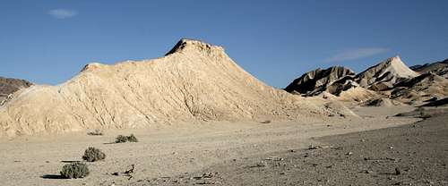
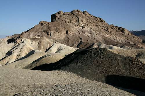
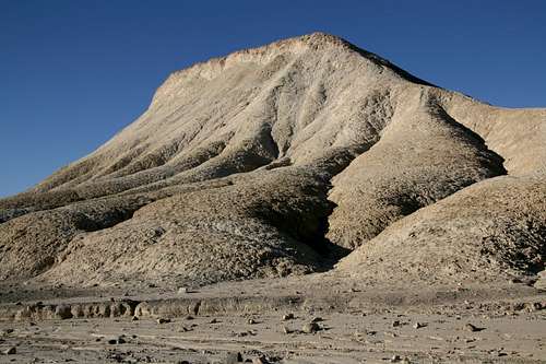
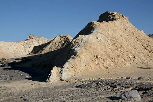
The badlands of Twenty Mule Team Canyon are adjacent to those of the Golden Canyon and Gower Gulch areas and are equally scenic, but they offer far more seclusion then their neighbors do, largely due to the lack of established hiking trails and a famous viewpoint like Zabriskie Point. There is an unpaved road (easily navigable for almost any vehicle) that winds for about four miles through the area, but the vast majority of visitors who get out of their cars here do so only to photograph wildflowers, mine tunnels, and badland buttes that are just a few steps away from the road (please do not sign the climber's log if all you have done here is drive through or get out only to view roadside attractions). This leaves acres and acres of small side canyons and washes to explore and buttes to hike and climb (the buttes here get up to around 1300' high, which is not towering but is higher than the buttes in the Golden Canyon/Gower Gulch area), taking one all the way to the slopes of the nearby Black Mountains, which form an imposing backdrop, if so desired. The buttes in the northern part of the canyon offer some of the most secluded and unique views of Manly Beacon and Red Cathedral, the signature peaks of the Golden Canyon/Gower Gulch area, to be found in Death Valley National Park. It is with these exploration opportunities in mind that I have created this page, and photographic trip report detailing a hike up one of the buttes appears further below.
Climbing here is not technically difficult (mostly Class 2, some Class 3)for the most part but can be challenging due to the nature of the rock. The "rock" is really hardened mud in most places, and it makes for sketchy footing and holds.
If you do hike or climb on the buttes, which is a rewarding experience, please try to stay on the "real" rock and on the buttes that have hard-packed trails as much as possible. The makeup of many of the buttes is loose and easily damaged, and your fun does not justify making long-term scars on the formations.
This is one of the hottest places on the planet, with summer daytime highs usually topping 110 degrees Fahrenheit and often surpassing 120 (I have personally “experienced” 130 at nearby Badwater Basin). Not carrying enough water (one gallon per person per day is the recommended amount) can be fatal. It is best to visit this area from late fall through early spring, but it is accessible all year long.
This is also a dangerous place to visit during wet conditions. Flash floods can be sudden and deadly, and it only takes a little moisture to turn the clays of the badlands into a goo that is almost impossible to hike through. Your feet can literally become stuck in the mud, and your next steps may leave your shoes behind.
Finally, avoid entering the numerous old mine openings in the area. You are allowed to go up to them and look inside, but it against park regulations to enter them. Among the reasons: deadly gases; scorpions, black widow spiders, and rattlesnakes (the old mine tunnels make perfect dens for these animals), and unstable ceilings.
Getting There
The turnoff for Twenty Mule Team Canyon is less than a mile south of Zabriskie Point on CA 190, about five miles east of Furnace Creek. The road is one-way only and runs north to south.
Red Tape, Camping and Lodging, and Links
There is an entrance fee of $20 for Death Valley National Park. There is a self-pay kiosk just south of the Dantes View turnoff (off CA 190 east of Zabriskie Point). You can also pay at the Furnace Creek Visitors Center. Because there are no entrance stations in Death Valley, it is easy to cheat on paying the fees. Remember, though, that your fees help support your parks.
Twenty Mule Team Canyon is a day-use area. It is closed at night and will be gated during wet conditions, when the road becomes impassable. The road conditions are no joke; my wife and I once stupidly spent a rainy night in the car here (my idea, truth be told), and if we hadn't had a vehicle equipped with 4-Low, the car would have been stuck for at least two days while the road dried out.
The nearest developed campgrounds are Furnace Creek, Sunset, and Texas Spring, all in the Furnace Creek area, about 11 miles from the Dantes View turnoff. Sites at Furnace Creek Campground can be reserved during the winter months.
You can backcountry camp here but should only do so if the chance of rain is nonexistent. Flash floods make camping in sandy washes a bad idea, and camping on the clay buttes in wet conditions can result in a displaced tent (with you inside) or an unbelievably messy campsite at the very least. The area is small enough that backcountry camping really doesn't make much sense.
Xanterra operates lodging facilities at Furnace Creek Ranch and Furnace Creek Inn. Rates are pricey, especially at the latter, but a stay at either facility often beats camping in the area, where nighttime temperatures are frequently uncomfortably warm.
Death Valley NPS site