
-
 8330 Hits
-
 85.87% Score
-
 21 Votes
|
|
Canyon |
|---|---|
|
|
36.42110°N / 116.8334°W |
|
|
Hiking, Scrambling, Canyoneering |
|
|
Spring, Summer, Fall, Winter |
|
|
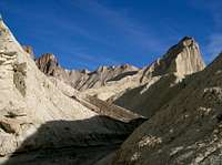 By Vladislav-- My favorite SP picture of Manly Beacon (no offense meant to anyone else)
Overview
Golden Canyon and Gower Gulch slice through some of the most colorful, most beautiful badlands in Death Valley National Park. A journey into this area early in the morning or late in the day means an entry into a realm of otherworldly form and hue.
The interpretive trail up Golden Canyon (a brochure is available at the trailhead), an easy mile (one-way), is likely the most popular true trail in the park, and it leads to an excellent viewpoint of Manly Beacon (climbable from Golden Canyon), which is not the highest formation in the area but which is probably the best-known and the most striking. At the end of that mile, the hiker has three choices: turn around, hike a 0.4-mile spur to the base of Red Cathedral (not climbable from Golden Canyon), or continue up-canyon. The third option leads to two more: hiking all the way to Zabriskie Point (total one-way distance of about 3 miles, with moderate elevation gain) or going back down Gower Gulch (the marked junction is just east of a very prominent yellow butte). The Golden Canyon/Gower Gulch route is about 4 miles in all and is a little more rugged than just Golden Canyon itself, as it involves the negotiation of two small dryfalls. The last stretch of trail is a rather boring hike of about half a mile between the mouths of Gower Gulh and Golden Canyon.
But this information is easily obtainable at the park, and the trail system is not the principal reason for this page. The principal reason for this page is to send a call to those who like to explore that this is an excellent place for it without having to make a long approach into the deeper parts of the Death Valley backcountry. There are seemingly countless badland buttes and larger formations to climb (some of the larger, rockier formations have Class 3 and 4 sections on treacherous rock), from which one can enjoy isolation and unbeatable views of the surrounding rugged terrain. And there are also seemingly countless side washes and narrow canyons that invite the curious. After just one bend, all those people hiking up and down the main canyon become a distant memory. The last time we were there, my wife and I found, close to the trailhead, a slot-like canyon winding and climbing to the north; we followed it for a few minutes and turned back so we would have time to reach the salt flats by sunset, but it was clear that the canyon continued on for some distance, and it beckons me to return.
 From Anya Jingle
Gower Gulch gets much less traffic than Golden Canyon does and thus has a quieter, wilder feel. It also has more mine ruins for those interested in them.
Climbing here is not technically difficult for the most part but can be challenging due to the nature of the rock. The "rock" is really hardened mud in most places, and it makes for sketchy footing and holds.
This is one of the hottest places on the planet, with summer daytime highs usually topping 110 degrees Fahrenheit and often surpassing 120 (I have personally “experienced” 130 at nearby Badwater Basin). Not carrying enough water (one gallon per person per day is the recommended amount) can be fatal. It is best to visit this area from late fall through early spring, but it is popular all year long.
This is also a dangerous place to visit during wet conditions. Flash floods can be sudden and deadly, and it only takes a little moisture to turn the clays of the badlands into a goo that is almost impossible to hike through.
Finally, avoid entering the numerous old mine openings in the area. You are allowed to go up to them and look inside, but it against park regulations to enter them. Among the reasons: deadly gases; scorpions, black widow spiders, and rattlesnakes (the old mine tunnels make perfect dens for these animals), and unstable ceilings.
If you hike off-trail over the buttes, which is a rewarding experience, please try to stay on the "real" rock and on the buttes that have hard-packed trails as much as possible. The makeup of many of the buttes is loose and easily damaged, and your fun does not justify making long-term scars on the formations.
Please do not attach photos taken from Zabriskie Point to this page (yes, I have sinned by including one from there of Gower Gulch-- author's license, if you will). The focus of this page is on hiking, scrambling, and exploring the canyons and buttes, and I would like the pictures to reflect that. Thank you.
 By Anya Jingle
Getting There
The trailhead for Golden Canyon is about a mile south on CA 178, which has its northern end just east of the Furnace Creek area. Golden Canyon and Gower Gulch can also be accessed from Zabriskie Point, the very popular and very beautiful viewpoint about 5 miles east of Furnace Creek on CA 190. Zabriskie Point actually overlooks the upper portions of Gower Gulch.

Red Tape, Camping and Lodging, and Links
There is an entrance fee of $20 for Death Valley National Park. There is a self-pay kiosk just south of the Dantes View turnoff (off CA 190 east of Zabriskie Point). You can also pay at the Furnace Creek Visitors Center. Because there are no entrance stations in Death Valley, it is easy to cheat on paying the fees. Remember, though, that your fees help support your parks.
The nearest developed campgrounds are Furnace Creek, Sunset, and Texas Spring, all in the Furnace Creek area, about 11 miles from the Dantes View turnoff. Sites at Furnace Creek Campground can be reserved during the winter months.
I have seen people backpacking into Golden Canyon, but one should only do so if the chance of rain is nonexistent. Flash floods make camping in sandy washes a bad idea, and camping on the clay buttes in wet conditions can result in a displaced tent (with you inside) or an unbelievably messy campsite at the very least. The area is small enough that backcountry camping really doesn't make much sense.
Xanterra operates lodging facilities at Furnace Creek Ranch and Furnace Creek Inn. Rates are pricey, especially at the latter, but a stay at either facility often beats camping in the area, where nighttime temperatures are frequently uncomfortably warm.
Death Valley NPS site
