
-
 5547 Hits
-
 72.08% Score
-
 2 Votes
|
|
Route |
|---|---|
|
|
42.80000°N / 0.10000°E |
|
|
Mountaineering, Scrambling |
|
|
Spring, Summer, Fall |
|
|
A long day |
|
|
5.4 (YDS) |
|
|
P.D.sup. |
|
|
III |
|
|
Overview
Nowadays it's probably the shortest of the “secure” routes of Pic Long but not the easiest (the easiest it’s the ridge NW but it's longer).Trailhead: Cap de Long
Slope: 1400m
Time: 4-5h to summit, total: 9-10h
Getting There
See the main page to approach to Cap de Long, trailhead of the route.Route Description
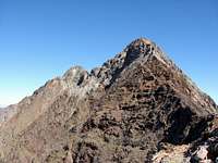 Pic Long & Badet
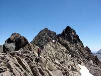 Ridge SE
 Final climb
The first part it’s the same of normal route of Pic Badet.
In the summit of Badet we’ll walk over the blocks of rock following some little cairns descending in the side of glacier of Pays Baché in the ridge. In the approach to first aiguille (not relevance as indepent summit in the official list of peaks of 3000m) the route goes to right side descending in good terraces of I and I+ (it's narrow and exposed but it's very easy) to reach one wall under us. It's a terrain of bad rock, with land, a lot of little stones and grade II. I think is necessary a good experience in rock climb to descent without rope in this point. It's the most difficult pass to reach the exit over a channel over the glacier (this chimney-channel it's possible to use to make rappel of 70 meters to the glacier in two rappels). The chimney in front of us to the next summit is secure and althoug the grade is II+ it's not exposed and we'll enjoy for leave the bad cracked rock. We'll exit of the chimney in the summit of the little Aiguille Badet (3135m), a secondary summit. After a descent of I+ in the wall we'll walk over the blocks in a very wide area not exposed. We'll traverse near of the exit of the classic chimney (Hourquette de Cap de Long) equiped with strings (we'll use this point to descent to glacier with two rappels if we want after the summit of Pic Long). The terrain has some climbs of I, I+ and even II- but it's easier following the cairns to the summit of Pic Long (3192m). The landscape of reward is impressive over the lakes of Tourrat, Cap de Long, the massifs of Balaitous, Vigemale, Néouvielle, Ardiden, Midi de Bigorre,…
Options for the descent:
a)The most adivisable is to return to Hourquette de Cap de Long and make two rappels to descent 80 meters to the glacier. In the glacier we’ll turn to west to return to the route of ascent and Cap de Long.
b)The return of the same route of ascent. The descent of Ag.Badet it’s now more complicated and the ascent of the wall in bad terrain it’s not good.
c)The ridge NW to Dent d’Estibère Male (P.D.). The ridge has cracked rock and it's harder to descent than to ascent with a lot of free stones. It's necessary experience in rock-climb and the use of the rope is very advisable (exposed).
Essential Gear
Two ropes of almost 30 meters (or 1 of 60m) but it's advisable two of 60 meters (it rest only 20 meters to the glacier, but with 30 meters in august you'll need 3 rappels probably).In may-june the snow cover the bottom of the chimney of descent and it's possible that you'll need crampons and ice-axe (40º in snow) or make another rappel in the snow to evitate it. As well in the area of ascent to Badet remain snow in may-june but in july and august don't exist.