
-
 33772 Hits
-
 89.77% Score
-
 30 Votes
|
|
Area/Range |
|---|---|
|
|
34.85664°N / 101.56174°W |
|
|
Hiking, Bouldering, Scrambling |
|
|
Spring, Summer, Fall, Winter |
|
|
Overview
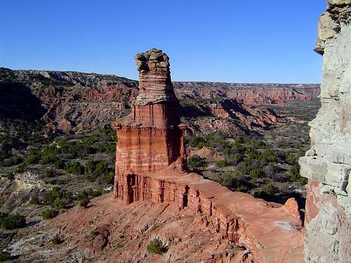 The Lighthouse in the Palo Duro Canyon, perhaps the most enduring symbol of the Caprock Canyonlands
The Caprock Canyonlands of Texas and New Mexico is an archetypal American landscape. Infinite plains, stunning canyons both grand and subtle, colorful badlands and mesas, balanced rocks, juniper and wild, free flowing rivers combine to create a place not easily put out of one’s mind.
The Caprock is a layer of rock lying immediately under the sediment of the Llano Estacado and parts of northeastern New Mexico. It is often exposed in the dramatic cliffs created by the erosion. The Caprock Canyonlands are so named because of the numerous canyons gouged out of the caprock that lines the severe escarpments in Texas and New Mexico. These escarpments mark the point where the high plains fall away precipitously into the rolling plains below. There are four primary escarpments in the Caprock Canyonlands. The most well known is the Caprock Escarpment on the eastern side of the Llano Estacado in Texas. While little known outside of Texas, this is closest to population centers. The Mescalero Escarpment in New Mexico marks the western terminus of the Llano. A little further north is a major line of cliffs simply called The Caprock. The is separate from the Caprock Escarpment. To the even further north is the Canadian Escarpment. While not a part of the Llano Estacado, this series of cliffs is similar to the previous two in geology and is in close proximity to the others. It is also formed by the Canadian River, which marks the northern end of the Caprock and Mescalero Escarpments.
In Texas, the caprock lies beneath the farmlands of the Llano Estacado. Spanish for “staked plains”, the Llano Estacado is one of the flattest regions in the US. Legend has it that when Coronado made his way across the Llano while searching for the fabled seven cities of gold in sixteenth century, he was forced to drive tall stakes into the ground in order to mark his route since the top of the Llano is utterly devoid of landmarks. While some doubt the veracity of this tale, it is not hard to imagine a string of tall poles driven into the ground being necessary to navigate the region if all the farms and towns were to suddenly disappear.
The Llano Estacado extends from the region south of Lubbock to the Canadian River Valley, north of Amarillo and well into New Mexico, terminating east of Roswell around the appropriately named community of Caprock. On most sides the Llano tapers off gradually, with a slight escarpment of a hundred to two hundred feet marking the final extent. Traveling west on Interstate 40 one can observe the relief east of the New Mexico – Texas state line. East of Amarillo the loss of elevation is almost imperceptible. There is little to hint at the fantastic canyons lurking amidst the eastern escarpment.
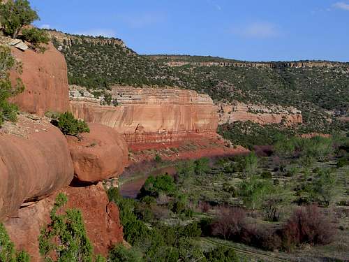 Canadian River Canyon
While they are found along the whole expanse of the eastern rim of the Llano, the canyons are particularly prominent in the northeastern region. Here one finds the famous Palo Duro Canyon, North and South Cita Canyons, Tule Canyon, North and South Prong Canyons, Quitaque Canyon and Los Lingos Canyon. These canyons are deep, rugged, and strangely reminiscent of landscapes found on the Colorado Plateau.
It is important to note that amongst all these canyons, only the extreme western end of the Palo Duro Canyon, the North Cita Canyon, North and South Prong Canyons and a right of way through Quitaque Canyon are open to public access. North Cita and the Palo Duro are found in Palo Duro Canyon State Park while North and South Prong Canyons are in Caprock Canyons State Park. The Caprock Canyons Trailway, a rails to trails conversion passes through Quitaque Canyon on an old railroad bed. Access is limited exclusively to the right of way and designated off trail areas. As disappointing as this is, there is still plenty of room in the accessible canyons to make a weeklong trip to the region worthwhile.
A Caprock Rim Trail was suggested at one time and was actually designed by Texas Tech students. Unfortunately little was accomplished on the ground. Many of the land owners are justifiably suspicious of government intent to acquire their land.
Although it is not on the Llano Estacado, the Canadian River Canyon in northeastern New Mexico is also included in the Caprock Canyonlands. Author Dan Flores in his book “Caprock Canyonlands”, the only book on the region, handily establishes the reasons for this. He notes that while separated by a fair distance, the Canadian River Canyon and the canyons of Texas share not only a common geology but also a common cultural history, since both were home to Kiowa and Comanche Indians and ranchers.
Regional Map
 The Caprock Canyonlands
Access
Five areas in the Caprock Canyonlands are accessible to the public. Three are found on the Llano Estacado in Texas and two sections of the Canadian River Canyon in New Mexico are open.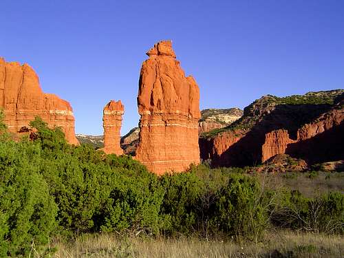 South Prong Mitten in Caprock Canyons State Park
Palo Duro Canyon State Park
The largest part of the Caprock in Texas that is available to the general public. Formerly containing only 16,000 acres of the western end of the canyon, the park was recently expanded to over 26,000 acres. The new lands include the cliffs and badlands along the southern edge of the canyon as well as sections along the Prairie Dog Town Fork of the Red River. This are is the most extensive and extensively used part of the Texas Caprock. Numerous trails are available to hikers, mountain bikers and horseback riders. However, those searching for an excellent wilderness experience should head for North Cita Canyon, in the remote southern part of the park.
Caprock Canyons State Park
Containing over 15,000 acres along the Caprock Escarpment, this state park contains some of the wildest terrain on the Llano. While over half the park is below the escarpment, the trail winding through the North and South Prong Canyons offers excellent redrock wilderness. Those frustrated with the development in the Palo Duro Canyon should head here.
Caprock Canyons Trailway
A recent 'rails to trails' conversion, this Texas State Parks run trail winds over 64 miles through the caprock and plains below the escarpment. The most notable section is the western portion of the trail, which passes through Quitaque Canyon. Additional interest is provided by the routing over old railroad bridges and through tunnels. Camping is permitted along the trail but do not stray far, since the trail only provides access to the old train right-of-way.
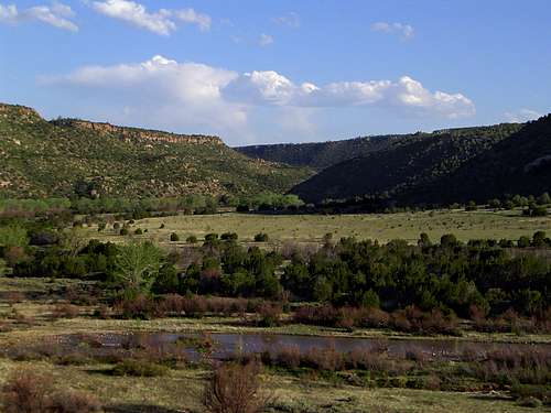 Canadian River Canyon in Kiowa National Grassland
Kiowa National Grassland
The westernmost unit of the Kiowa National Grassland (operated by Cibola National Forest) contains 20 miles of the Canadian River Canyon. This section is known locally as "Mills Canyon". Hiking and camping is excellent, both in the canyon and along the rim. Outside of hunting season, few people ever venture here.
Sabinoso Wilderness
Administered by the BLM, this area is set to receive wilderness status in the new future as a result of legislation passed in January of 2009. Wild and rugged, this is one of the most remote regions in New Mexico.
History
 New Mexico's Canadian River Canyon
 Sediment strata beneath the Caprock in South Prong Canyon
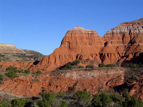 Badlands in the Palo Duro Canyon
Prehistory
The history of the Caprock dates to prehistoric times. Comanche and Kiowa Indians both traveled across the area. The Palo Duro Canyon and the Canadian River Canyon were particularly attractive to the Native Americans, who were drawn by the waters of the Prairie Dog Town Fork of the Red River and the Canadian River. The rivers also meant an unusual abundance of game and vegetation. The Comanche in particular made their homes in the Palo Duro canyon, while the Kiowa frequented the canyon of the Canadian River. It is believed that human habitation in this region extends back thousands of years.
The Coronado Expedition
In 1540 the Spanish explorer Francisco Coronado began his expedition in search of Cibola, the fabled lost city of gold. He crossed New Mexico along the route of what is now Interstate 40. In 1541 he made his way across Llano Estacado and camped in the Palo Duro canyon. At the time the canyon was occupied by Apaches, but they were eventually displaced by Comanches because they had the advantage of horses given them by the Spanish. Coronado’s expedition proved fruitless and few Europeans came to the region for almost three hundred years.
Battle of the Palo Duro
In 1852 the region was surveyed and mapped under an expedition led by Captain Randolph Marcy. As Texan settlers pushed further west, they came into increased conflict with the Comanche. This conflict came to a head in 1874 when a U.S. army force under Colonel Ranald MacKenzie was dispatched to remove the Comanche to the Fort Sill Agency in Oklahoma. He was able to capture thousands of Comanche horses in Tule Canyon, south of the Palo Duro. Denied their favorite means of combat and after the brief Battle of the Palo Duro, the Comanche capitulated and moved to Oklahoma.
The Loving – Goodnight Era
Famed cowboys Oliver Loving and Charlie Goodnight blazed the Loving – Goodnight Trail across the Llano Estacado in 1866. The trail crossed the Llano and then traveled north along the Pecos to Fort Sumner. At the time the region was hazardous because of the Comanche and Kiowa. The hazard was exacerbated by the lack of water. On the first drive, Loving and Goodnight pushed the herd for four days with no water. When they came in sight of the Pecos the herd stampeded to get to the water. This event and Loving’s death and Goodnight’s journey to return his body to Texas, along with their close friendship was the genesis of the story told in the novel and movie Lonesome Dove. On a historical side note, Goodnight invented the chuckwagon on the 1866 drive.
Despite Loving’s death in 1867, Charlie Goodnight remained in the cattle business with an eye on the Caprock region. Following the Battle of the Palo Duro, he established the JA Ranch in the Palo Duro Canyon. This outpost was largely responsible for opening West Texas up for settlement. Charlie Goodnight died in 1929.
The Dust Bowl
The Caprock region suffered significantly during the Dust Bowl Era. Many of the homesteads in the Canadian River Canyon went bankrupt and the federal government acquired the land. The homesteads were later combined to form part of the Kiowa National Grassland. In Texas, many of the farms went bankrupt as well, which prompted the National Park Service to perform investigations regarding the desirability of acquiring the land for a Caprock oriented National Park. The NPS eventually passed on the opportunity after the Badlands in South Dakota came under its control. The terrain was considered too similar to warrant two National Parks. While the NPS had looked at acquiring 100,000’s of acres, only two small chunks of the Texas Caprock has been opened to public access. In 1934 the upper Palo Duro Canyon was purchased and became Palo Duro Canyon State Park. Caprock Canyons State Park was purchased in 1982. The right of way through Quitaque Canyon was acquired in 1993.
Dan Flores’ book Caprock Canyonlands is a fantastic resource for the history and geology of this region.
Getting There
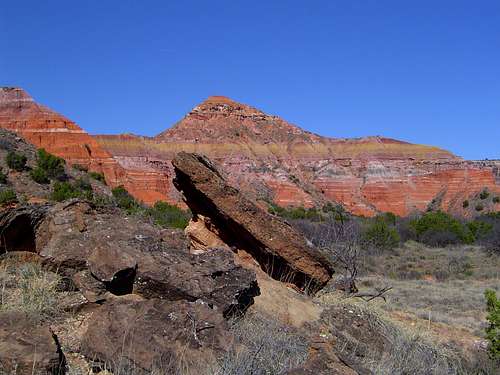 Capitol Peak in the Palo Duro Canyon
Public access to the Caprock Canyonlands is scattered since the public lands do not form a contiguous block. The routes to nearly every accessible canyon is found along Interstate 40 between Amarillo and Tucumcari. Other than the Canadian River Canyon, all canyons are found south of Amarillo.
Palo Duro Canyon State Park:
From Interstate 27 go west on Palo Duro Road (Highway 217) to the entrance gate.
Caprock Canyons State Park:
From Interstate 27, travel east on Highway 86 at the town of Tulia. The state park is on the left side of the highway once past the town of Silverton.
From Texas State Highway 287 go east on Highway 86 at the town of Estelline. The state park is on the right side of the highway once past the town of Quitaque.
Caprock Canyons State Trailway:
Access to the trailway is found in numerous areas along the length of the trail. The best and most interesting region is Quitaque Canyon, which is found southwest of the town of Quitaque.
Canadian River Canyon:
From Interstate 25 at Springer, go east on Highway 56/412. Turn south on Highway 39 and proceed to the “town” of Mills, which is really a small and sporadic grouping of ranches. Turn west onto a dirt road at the signed turnoff by a ranch house. Continue to follow the signs through fields until you drop into the canyon. The road is rough and while a low clearence vehicle could probably make it, I would recommend against it.
From Interstate 40 proceed to Logan, New Mexico. Directions to Logan depend on which direction you are approaching on I-40. At Logan head north on Highway 39 to Mills. Follow the above direction from there.
Red Tape
 Mills ruin in the Canadian River Canyon
 Palo Duro Canyon
Entrance fees are required at both the Palo Duro State Park and Caprock Canyons State Park. Normal Texas State Park rules apply in both areas. However, while the Palo Duro is generally overdeveloped in typical Texas State Park fashion, there is plenty of undeveloped and untraveled areas in the park, especially in the southern part of the park, in North Cita Canyon. This is a pretty spectacular area accessible only to those willing to do some cross-country route finding. Caprock Canyons is nicely undeveloped, by Texas State Park standards.
When on the Caprock Canyons State Trailway, it is important to make sure one stays on the right-of-way. The areas on either side of the trail is private property.
The Canadian River Canyon is in the Kiowa National Grassland, which is administered by the Cibola National Forest. While it is not an official wilderness, it is essentially wild in character, aside from the vehicular access, and should be treated as such.
Historic sites and ruins exist in many areas in the Caprock Canyonlands. It is illegal and unethical to tamper or remove any artifacts.
Palo Duro Canyon State Park
11450 Park Road 5
Canyon, TX 79015
(806)488-2227
Caprock Canyons State Park & Trailway
P O Box 204
Quitaque TX 79255
(806)455-1492
Canadian River Canyon (Kiowa National Grassland)
714 Main Street
Clayton, New Mexico
88415
Phone:
(505) 374-9652 [voice];
(505) 374-9664 [fax]
Camping
 Sandstone cliffs in the Canadian River Canyon
There are numerous options for camping in the Caprock Canyonlands.
There are campgrounds in Palo Duro Canyon State Park, Caprock Canyons State Park and in the Canadian River Canyon. Backpacking in the two Texas State Parks is possible and there are backpacking campgrounds and some dispersed camping is permitted, depending on what part of the park one is in. There are also campsites alongside the Caprock Canyons State Trailway. The Canadian River Canyon has a free Forest Service Campground beside the Canadian River, but there is plenty of superior dispersed camping as well.
External Links
Palo Duro CanyonPalo Duro Canyon State Park
Caprock Canyons State Park
Kiowa National Grassland