
-
 4961 Hits
-
 78.27% Score
-
 9 Votes
|
|
Route |
|---|---|
|
|
34.45958°N / 101.11404°W |
|
|
Hiking, Scrambling |
|
|
Spring, Summer, Fall, Winter |
|
|
Overview
 Sandstone formation in South Prong Canyon
Texas’ Caprock Escarpment is one of the most scenic regions in all of America’s plains region. Like the rest of the state, most of the area is privately owned, making access to some of the most spectacular areas difficult to impossible. Thankfully, Caprock Canyons State Park is a 15,300 acre oasis of publicly held land that exhibits a fantastic sampler of what the Caprock has to offer. Greater detail on the Caprock is available here. The trail that winds through North and South Prong Canyons is one of the finest trails in Texas. The route offers soaring red cliffs, strange pinnacles, hoodoos and balanced rocks. While these attributes may seem more appropriate on the Colorado Plateau, they are not the only unexpected commodities found on this trail. Surprisingly, in this land of ranches and agriculture on the vast, flat plains, the trail through the Prong Canyons offers both a taste of Caprock wilderness as well as views. It is truly a perplexing sight amidst a region the Kiowa called the Horizontal Yellow.
The trail through the Prong Canyons is a loop hike that can be started from either a trailhead or from the South Prong Tent Campground. To complete the loop, a 0.5 mile stretch of road must be traveled. This route description will begin at the campground and proceed counterclockwise. The trail is roughly 6 miles in length.
 Looking west into South Prong Canyon
Route Description
 Entrance into North Prong Canyon
From the South Prong Tent Campground, walk east on the park road for nearly 0.5 miles. Turn left onto the access road to the trailhead. It is possible to begin the hike here but to complete the loop would require ending the hike by walking on the road. It is better to get the road out of the way first. At the trailhead there is a trail that departs to the east. This is the Lower Canyon Trail, which is a popular route with equestrians. While it does connect to the Prong Canyons Loop Trail, it does not add anything significant other than length.
Proceeding north on the Prong Canyon Trail, the route follows the perimeter of Haynes Ridge, a 2 mile long mesa that forms the divide between North and South Prong Canyons. Approximately 0.4 miles from the trailhead a faint use trail climbs steeply up the wall of the ridge. Another 0.5 miles beyond this point, the trail passes a junction with the short trail that leads to the North Prong primitive camp. From here the trail turns to the west, passing the northern junction with the Lower Canyon Trail. Continuing east, the route enters into North Prong Canyon. The red and white cliffs rise 500 to 600 feet above the canyon bottom. Sandstone pinnacles are visible, particularly on the southern cliffs.
The trail stays on the south side of the usually dry bed of the North Prong of the Red River. Junipers dot the landscape, their green color contrasting against the red cliffs. After a mile beyond the Lower Canyon junction, the Prong Canyon trail crosses over to the north side of the creek. In both the north and south canyons the State Park engineers opted not to route the trail along the contours of the canyon or the creek, instead preferring to give the trail a stark, linear austerity. In spite of the lack of imaginative trail design, the canyon is beautiful. It is difficult to imagine this canyon being in southern Utah rather than in the midst of the vast plains of Texas.
 A balanced rock on the cliffs above South Prong Canyon
As the trail proceeds west, the canyon narrows dramatically and the vegetation becomes much thicker. Eventually the canyon closes in altogether into a box, the end marked by an overhang with lush ferns growing on it. The ferns are indicative a seep. The trail turns to the south and begins climbing up to the top of Haynes Ridge. As it gains elevation views to the east, down the length of North Prong Canyon improve. After climbing nearly 400 feet in 0.2 miles the route reaches the unyieldingly flat ridge top. As an outlier of the Llano Estacado, the top of Haynes Ridge lacks the topography of the canyons. At the top of the ridge a 2 mile long trail heads east to an overlook high above the trailhead. The use trail branching off the beginning of the trail connects to this point. Beyond the junction with the path along Haynes Ridge, the trail drops down the south side of the ridge into South Prong Canyon. Views during the descent are some of the best on the route. South Prong Canyon is more dramatic than its northern twin because of ruggedness of the cliffs and the monumental pinnacles visible in the distance. The views to the west, into the upper canyon are also good. This section of South Prong canyon is outside of the state park and is owned by the Boy Scouts. As the trail descends into the canyon it crosses over red slickrock, highlighted by some unusually eroded hoodoos with small, balanced rocks.
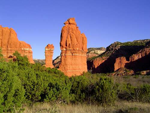 The South Prong Mitten
Once the trail reaches the canyon bottom, it turns east. Again, the trail engineers did not cut any corners, pushing the trail straight down the canyon. The route crosses the dry creek bed numerous times. A mile past the junction with the Haynes Ridge route, a short spur leads to the South Prong Primitive Camp. From this point it is another 1.25 miles back to the South Prong Tent Campground and the end of the trail. Along the way one passes through the prettiest sections of the trail, highlighted by the South Prong Mitten, a tall sandstone tower.
Trail Map
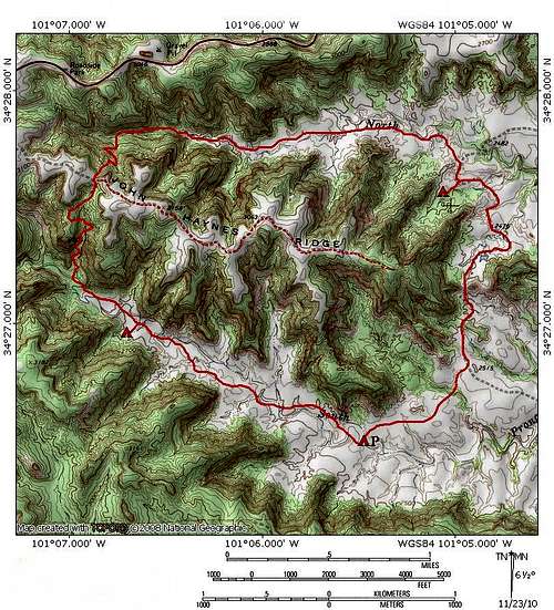 Prong Canyon Trail Map
Getting There
 The cliffs of South Prong Canyon from the tent campground
From Interstate 27, travel east on Highway 86 at the town of Tulia. The state park is on the left side of the highway once past the town of Silverton.
From Texas State Highway 287 go east on Highway 86 at the town of Estelline. The state park is on the right side of the highway once past the town of Quitaque.
From the entrance gate, follow the park road to its end at the parking lot for the South Prong Tent campground.