
|
|
Route |
|---|---|
|
|
39.77550°N / 106.3505°W |
|
|
Scramble |
|
|
A few days |
|
|
Class 3 |
|
|
Approach
From Highway 9 about 16 miles north of Silverthorne (16.7 miles from exit 205 on I-70) turn west on County Road 30 (at the south end of Green Mountain Reservoir) posted for Heeney. Follow the road 5.4 miles to County Road 1725 (Cataract Creek Road) and turn left following the road 2.3 miles to the Surprise Trailhead. Or from Kremmling, follow Highway 9 south for about 12.4 miles to the Green Mountain Reservoir. Follow County Road 30 passing along Green Mountain Reservoir and through Heeney for 5.1 miles to County Road 1725 (Cataract Creek Road) and turn right following the road 2.3 miles to the Surprise Trailhead at Lower Cataract Lake. There is a small fee for parking at the trailhead. The road is gravel, but any car should be able to make it to the trailhead. The trailhead is at 8590 feet elevation.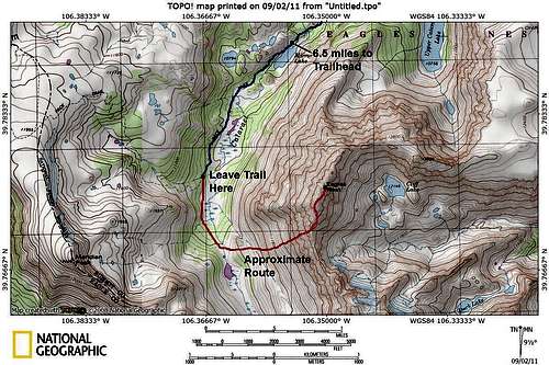 Close Up Map of Climbing Route
 Overview Map
Route Description
From the trailhead follow the Surprise Trail south for 2.6 miles to a junction with the Gore Range Trail. Turn right and follow the trail a short distance to Surprise Lake. Continue west along the Gore Range Trail reaching another junction after after 0.6 miles from Surprise Lake. Turn left here and follow the trail 1.9 mile to Upper Cataract Lake. Upper Cataract Lake is in a very spectacular setting and the huge north face of Eagles Nest Peak (but not the highest summit) is in full view. The lake is at 10,756 feet and 5.1 miles from the trailhead.From Cataract Lake, continue along the trail with some up and downs before descending to Mirror Lake after another 1.4 miles from Upper Cataract Lake. Mirror Lake is also in a spectacular setting and is at 10,560 feet elevation.
From Mirror Lake, follow the trail southwest passing through some beautiful meadows. After 1.2 miles from Mirror Lake, the trail crosses a small stream and begins to climb west and away from Cataract Creek (at about 39*46.618'N and 106*22.006'W). Leave the trail here. Follow Cataract Creek south, but stay on the rocky hillside to the west to avoid several marshy areas. Cataract Creek climbs to a small lake (39*46.000'N and 106*21.812'W) located east and slightly north of point 12,211. The lake is at 11,050 feet elevation and is reached after 0.8 miles after leaving the trail.
From the small lake, the destination is the ridge north of the saddle located directly to the east that is between Eagles Nest on the North and Mount Powell to the south.
Head cross-country to the northeast along the steep and rocky slope up to a point roughly half way between the saddle at 12,800 feet and Eagles Nest Peak. You can make a run directly towards the saddle, but from the saddle to the summit, there are many pinnacles and the ridge is rough.
The route is really steep to the ridgeline. From the ridgeline, follow the rugged ridge north to the summit of Eagles Nest Peak. There are several little summits/pinnacles along the rugged ridge and the middle summit is the highest. The summit Eagles Nest Peak is about 10 miles from the Cataract Lake (Surprise) trailhead, but it seems longer because the route is so rugged.
It also appears possible to traverse along the ridge south to Mount Powell, but the ridge is rugged and it appears to be very slow-going.
 This is the west face and least rugged face of Eagles Nest. This route climbs the slopes near the right side of the photo.
ipbrogden - Aug 9, 2015 3:44 pm - Hasn't voted
Summit locationThe summit register can be found on the eastmost bump on the ridge, not the middle one.
Scott - Aug 10, 2015 11:57 pm - Hasn't voted
Re: Summit locationThanks. I thought the central summit was the highest. I assume you mean the northernmost bump? Do you think that is the highest point, or just where the register is located? I can edit the page. It's been a long time since I was up there.