
|
|
Route |
|---|---|
|
|
39.77550°N / 106.3505°W |
|
|
Scramble |
|
|
A few days |
|
|
Class 3 |
|
|
Approach
Follow Highway 9 north of Silverthorne or south of Kremmling, to County Road 10-Spring Creek Road which branches to the west of Highway 9 between mile post 128 and 129. (This is 2.5 miles north of Green Mountain Reservoir). Follow the gravel road (County Road 10) west turning right after a short distance at a "public access" sign. Go straight at the intersection at 6.3 miles from the highway. After another 1.1 miles, turn right at the road posted for "Sheephorn Drive" and "Mahan Lake". Stay on the main track until you reach an interesection 10.4 miles from the highway (3 miles from the Sheephorn Drive sign). Stay left following the road posted for Mahan Lake. In another 1.6 miles, turn right at the fork. After another mile turn left and follow the short track to Blue Lake. This is the trailhead. The road to the trailhead is pretty rough for passenger cars. The trailhead is at 11,160 feet elevation.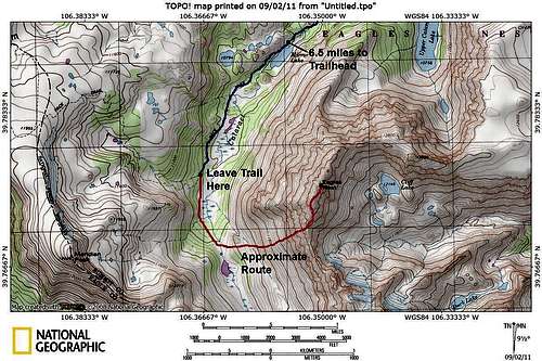 Close Up Map of Climbing Route
 Overview Map
Route Description
From the trailhead at Blue Lake, follow the trail, which is an old blocked off 4wd road, along the west side of Elliot Ridge. The trail gains elevation at a rather gentle grade up to the timberline after a short distance. There is a marshy meadow after 0.9 miles and the trail is marked with post and cairns above the timberline. Great views in all directions open up along the ridge. The trail reaches a minor saddle before climbing up to a highpoint along the ridge. The trail continues along the ridge to near another highpoint at 11,952 feet. Since the peak is a "ranked 11'er", peak baggers may want to take the short side trip to point 11,952 which is 3.8 miles from the trailhead.Beyond the point, the trail descends to a saddle at 11,650 feet before climbing along the gentle ridge to the junction with the Upper Cataract Trail after 4.9 miles from the trailhead and at 11,955 feet. From the junction, follow the Upper Cataract Trail 2 miles and down the slope to the east and to near Cataract Creek (at about 39*46.618'N and 106*22.006'W). This is where you leave the trail (1.2 miles short of Mirror Lake from the Elliot Ridge, and at about 39*46.618'N and 106*22.006'W). Follow Cataract Creek south, but stay on the rocky hillside to the west to avoid several marshy areas.
Cataract Creek climbs to a small lake (39*46.000'N and 106*21.812'W) located east and slightly north of point 12,211. The lake is at 11,050 feet elevation and is reached after 0.8 miles after leaving the trail.
From the small lake, the destination is the ridge north of the saddle located directly to the east that is between Eagles Nest on the North and Mount Powell to the south.
Head cross-country to the northeast along the steep and rocky slope up to a point roughly half way between the saddle at 12,800 feet and Eagles Nest Peak. You can make a run directly towards the saddle, but from the saddle to the summit, there are many pinnacles and the ridge is rough.
The route is really steep to the ridgeline. From the ridgeline, follow the rugged ridge north to the summit of Eagles Nest Peak. There are several little summits/pinnacles along the rugged ridge and the middle summit is the highest.
It also appears possible to traverse along the ridge south to Mount Powell, but the ridge is rugged and it appears to be very slow-going.
Eagles Nest Peak is about 9 miles from the Elliot Ridge Trailhead, but as mentioned, it seems longer because the last part of the route is so rugged.
 Looking toward Eagle's Nest from the Elliot Ridge trail.