Dark Drive Into Squatter's Camp
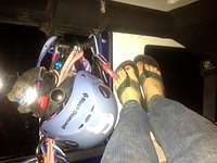
![Basecamp Rubicon]() Basecamp Rubicon - all the comforts of home, right?
Basecamp Rubicon - all the comforts of home, right?
Cruising out to the San Juans after work on a Friday night from the Colorado Front Range really leaves you impressed by your commitment to this crazy pastime of ours. The cadence of the journey is a familiar one by now: Meet up with climbing partners, leave behind the hustle and bustle of Colorado Springs, endure the searing heat of Cañon City, enter the mysterious depths of Big Horn Sheep Canyon, emerge into Salida as the sun is setting, crest the summit of Monarch Pass in cool mountain air, stop in Gunnison for gas and beer, then press on into the night into the heart of the San Juans.
Dropping southbound on US 550 always makes my heart beat a bit faster. Rolling out of Ouray and onto the dirt road that carries us into Yankee Boy Basin, we are faced with our first conundrum: Where the heck do we camp? Camping is officially banned in most of the basin, with only a few official Forest Service sites deemed entirely legal. The result is that a large body of visitors end up at unofficial squatters campsites. This night we were no exception. Jill and Doug each tucked a tent into the willows and I snuggled into Basecamp Rubicon for a short nap before our alpine wake-up.
Morning Tundra & Talus Slog, plus Death by Scree
![Descending the notch]() Descending the notch
Descending the notch![Steep tundra slog]() Steep tundra slog
Steep tundra slog![Approaching Teakettle]() Approaching Teakettle
Approaching Teakettle
I expected the ascent of Teakettle Mountain out of Yankee Boy Basin to be steep, and indeed, from the minute your feet leave the dirt road, this is one steep slog. The slopes begin as what many of us lovingly call
"Third Class Grass" then crumble into the familiar misery of San Juan Talus & Scree. A variation of the "dinner plate talus theme," the upper slopes approaching the saddle between "Coffee Pot" and Potosi Peak are studded with chips of rock closely resembling martial arts throwing stars.
Gaining the ridge between Teakettle Mountain and Potosi Peak, we are treated to amazing views. Most notable, Teakettle herself looms rugged and wild to the northwest while Potosi looks menacing to the southeast. Views across the Yankee Boy Basin begin to open up as the sun highlights the ridgelines and summit crests.
After all that elevation gain, it's time to...descend? Yeah, descend. Down a hideous slope of scree. There is no way to avoid raining down pebbles and small rocks on your partners, you simply jockey to avoid being the first one downhill collecting the most shrapnel.
At Last! The Summit Block of Teakettle Mountain
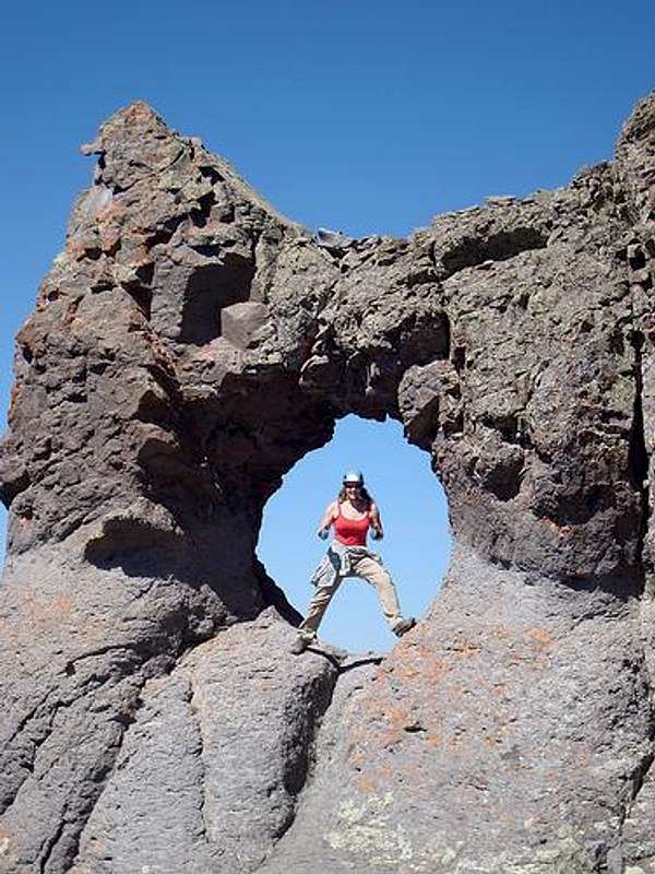
The famous Teakettle Handle!
![some fool]() Me in the handle
Me in the handle![Another party finishes]() Another party finishes Another party finishes | ![Doug in the handle]() Doug in the handle Doug in the handle | ![Teakettle handle and summitblock]() Teakettle handle & summit Teakettle handle & summit |
I don't care how many photos you've seen of the Teakettle summit block and famous "handle," when you experience the top of this peak in real life, you can't help but be amused! This really is a very cool and special place. Who can resist crawling into the handle to have your photo taken. I found myself marveling at the powers of nature that formed this feature!
Even better, the hole in the handle nicely frames views of other San Juan high peaks. Dallas Peak looks especially fetching when viewed through the handle of Teakettle Mountain!
The weather was holding beautifully, and it was time to prepare for our final summit block ascent.
The Summit Block
![Jill heading up]() Jill heading up
Jill heading up![Summit high five]() Summit high five Summit high five | ![Potosi]() Potosi views! Potosi views! | ![Doug descending]() Doug descending Doug descending |
As we approached the summit of Teakettle Mountain, we noticed a party of two working the summit block. They were descending as we got into talking distance and Jill quickly recognized one of the other climbers from a Rainier outing. It was, indeed, SP's own
theREALCarpeDM and his partner Shawn (Sean?) Yet another great reminder to be nice to people you meet in the highcountry, because this is a small, tight-knit community! It was great running into a couple kindered spirits in such a neat alpine spot!
We lugged out the rope and gear and prepared to ascend the summit block. I wedged myself into an impossibly uncomfortable belayed "stance," basically squished against the ground between two boulders with some questionably crumbly looking rock slung for backup. Thankfully, Doug led the summit pitch quickly and set up his summit anchor, relieving me of even one more minute crammed into this awkward little crevice.
First I made my way to the summit, then Jill. The views of rustic San Juan summits against blue sky from the tiny little perch are breathtaking!!!
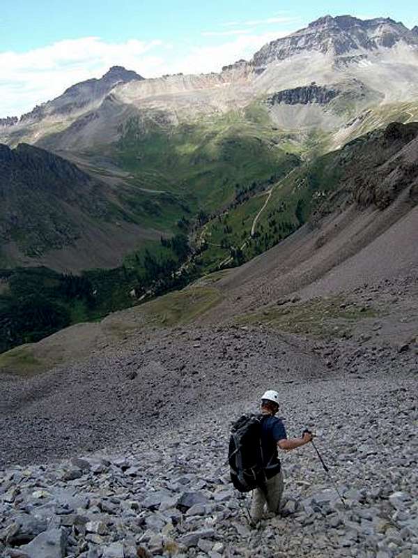
Direct Descent from Teakettle
![Talus Pour-Off]() Talus Pour-Off
Talus Pour-Off![Scree and Talus]() Scree and talus...lather, rinse, repeat
Scree and talus...lather, rinse, repeat
I'll let the pictures do most the talking for this segment of the outing. From the summit of Teakettle Mountain, we headed down the Black Gully, and then kept on going to "enjoy" the direct line of descent from Teakettle.
Hideous. At times, we were literally up to our shins in talus!
The talus is steep, deep and sharp. We kept our collective sense of humor intact on this section by laughing and joking, but not a single one of us mourned when our stint in Talus Hell finally ended.
![Scree Ski]() Scree ski Scree ski | ![Black Gully]() Black Gully Black Gully | ![Direct descent]() Direct descent Direct descent | ![Continuing down]() Continuing down Continuing down | ![Jill descending Talus Hell]() Jill descending Talus Hell Jill descending Talus Hell |
Let the Celebration Begin!
![Centennial Celebration]() Centennial Celebration
Centennial Celebration![The Payoff!]() The Payoff!
The Payoff!
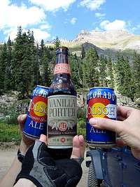
To celebrate our freedom from the merciless talus fields and scree slopes, we promptly cracked open cold beers awaiting us at the Jeep. It was then that Jill had a marvelous idea:
Let's make our Centennial Finishing drink one ounce of beer for every Centennial Peak he's finished. One hundred peaks x 1 oz of beer each = 100 oz of beer. Brilliant!
Before you shrug, keep two things in mind about our Centennial Finisher:
1. He's a total lightweight when it comes to alcohol consumption.
2. He is goofy to an extreme without the beer.
Encore on Gilpin Peak!
![Mount Sneffels from Gilpin Peak]() Mount Sneffels from Gilpin Peak Mount Sneffels from Gilpin Peak | ![North Ridge of Gilpin Peak]() North Ridge of Gilpin Peak North Ridge of Gilpin Peak |
![Gilpin Peak 13,694]() Gilpin Peak 13,694 ft. Gilpin Peak 13,694 ft. | ![Gilpin Rock Glacier]() Gilpin Rock Glacier Gilpin Rock Glacier |
![Upper lot for Gilpin (12,460 feet / 3798 meters)]() Upper lot for Gilpin Upper lot for Gilpin | ![Approaching Gilpin Peak North Couloir]() Approaching Gilpin Peak North Couloir Approaching Gilpin Peak North Couloir | ![Summit Ridge, Gilpin Peak]() Summit Ridge, Gilpin Peak Summit Ridge, Gilpin Peak |
The iPhone alarm rings in Basecamp Rubicon. I look out the windows, half expecting to see my fellow climbers opting to stay in their tents a little longer to sleep off the previous evenings' celebration. Yet, out the driver's side window, I see a light on in a tent. Time to wake up! (Climbers, after all, are pretty hardy folks!)
I enjoyed the Jeep drive up to the high parking lot below Gilpin Peak, with the exception of the scary crunching and squeaking noise emanating from my lift kit (since fixed). There is no flat ground to park on, so I park the Jeep on some off-kilter, steeply sloped "spot," pull the parking break tight and cram rocks under the tires...we walk away hoping my truck will still be there upon our return!
![Gilpin Peak summit ridge views]() Gilpin Peak summit ridge views Gilpin Peak summit ridge views | ![Yankee Boy Basin Views]() Yankee Boy Basin Views Yankee Boy Basin Views | ![Into Yankee Boy Basin]() Into Yankee Boy Basin Into Yankee Boy Basin |
We started along the North Ridge toward the summit, but I had a huge hand-hold pull out on me and hurtle down the mountain, and Jill's bum knee started to bother her. So Jill went to sleep in the Jeep while Doug & I opted for the North Couloir. Throughout the entire ascent of the dry North Couloir, I had the Dierks Bentley song in my head "What Was I Thinking?" This route is dreadful in dry conditions: Absurdly steep in spots, loose talus sitting upon loose scree...it's honestly miserable.
It was with extraordinary relief that we reached the much-more-stable summit ridge and stomped the last few yards to the top. The descent, while awful, was not as bad as the clamber up the couloir, and in no time we were back to the Jeep to wake Jill and drive home.
![Gilpin Peak 13,694 Summit]() Gilpin Peak 13,694 Summit Gilpin Peak 13,694 Summit | ![Upper North Couloir]() Upper North Couloir Upper North Couloir | ![Descending steep junk]() Descending steep junk Descending steep junk | ![North Couloir, Gilpin Peak]() North Couloir, Gilpin Peak North Couloir, Gilpin Peak |
Comments
No comments posted yet.


 Another party finishes
 Doug in the handle
 Teakettle handle & summit
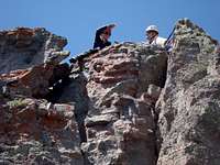 Summit high five
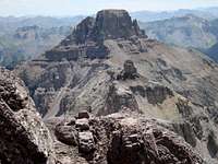 Potosi views!
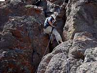 Doug descending
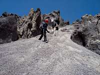 Scree ski
 Black Gully
 Direct descent
 Continuing down
 Jill descending Talus Hell
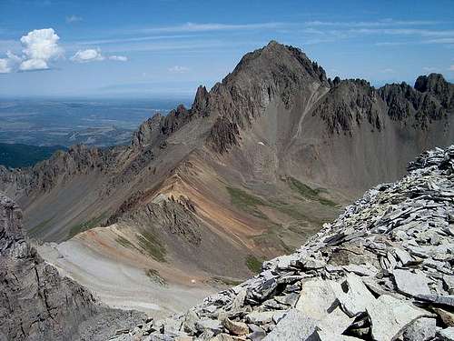 Mount Sneffels from Gilpin Peak
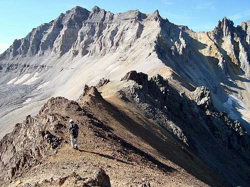 North Ridge of Gilpin Peak
 Gilpin Peak 13,694 ft.
 Gilpin Rock Glacier
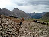 Upper lot for Gilpin
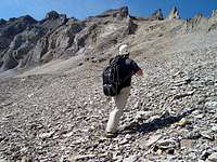 Approaching Gilpin Peak North Couloir
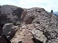 Summit Ridge, Gilpin Peak
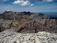 Gilpin Peak summit ridge views
 Yankee Boy Basin Views
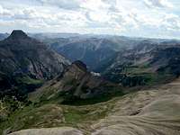 Into Yankee Boy Basin
 Gilpin Peak 13,694 Summit
 Upper North Couloir
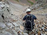 Descending steep junk
 North Couloir, Gilpin Peak