| Teakettle Mountain, "Coffeepot" & Potosi Peak Trip Report |
Contribute  Loading...
Geography Parents  Loading... Trip Reports Trip Reports Trip Reports
| Teakettle Mountain, "Coffeepot" & Potosi Peak   | 
| Page Type: Trip Report Location: Colorado, United States, North America Lat/Lon: 
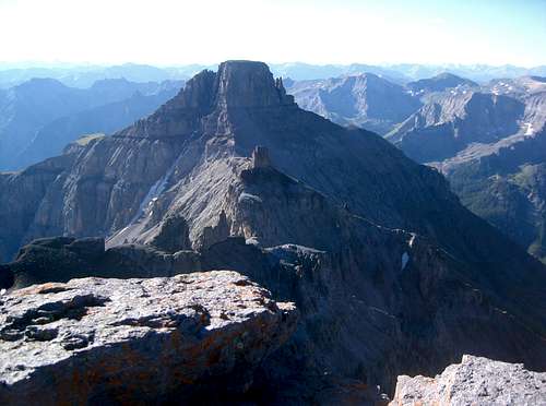
37.99630°N / 107.7568°W Date Climbed/Hiked: Aug 11, 2007 Activities: Hiking, Mountaineering, Trad Climbing, Scrambling Season: Summer | Page By: Brian Kalet Created/Edited: Aug 13, 2007 / Aug 16, 2007 Object ID: 323234 Hits: 2498  Loading... Page Score: 85.88% - 1 Votes  Loading... Vote: Log in to vote |
Stats
| Peak Name | CO Rank | Elevation |
| Teakettle Mountain | 98 |
13819 |
| "Coffeepot" | Unranked
| 13568 |
| Potosi Peak | 113
| 13786 |
Distance: ~7 miles
Elevation Gain: ~4600'
Participants: Brian Kalet and Wes Lloyd
Wes's Photos
Teakettle MountainWe camped at the 2WD trailhead at 10,700 feet Friday night. We began hiking around 5:45 am and reached the 4WD trailhead at about 6:15 am. We left the road and began hiking towards "Coffeepot". Routefinding was not an issue. After reaching the base of "Coffeepot", we descended towards the Black Gully. We climbed the Black Gully then did an ascending traverse to the base of Teakettle Mountain's summit block. We free soloed the summit block and got to the top at 8:25 am. The small summit was a treat. "Coffeepot" & Potosi from Teakettle |
"Coffeepot"We rappelled off the summit block. Wes changed out of his climbing shoes and we returned to the base of "Coffeepot". We traversed to the east side and free soloed the summit pitch. The rock was very loose. I got to the summit at 9:38 am. "Coffeepot" from its southeast ridge |
Potosi PeakWe downclimbed the summit pitch, descended Coffeepot's southeast ridge to the Potosi Peak-"Coffeepot" saddle, traversed Potosi Peak's west face, gained Potosi Peak's southeast ridge, traversed Potosi Peak's southeast face below cliffs, then climbed the wide gully below the summit. Instead of exiting, we climbed directly to the summit on third class rock. We got to the summit at 11:28 am. We descended our ascent route, but took the sandy gully east of the main gully at the top. We returned to the Potosi Peak-"Coffepot" saddle and descended down the broad chute. The loose rock was unpleasant. We crossed a gully south of the chute and gained a grassy slope. We descended the grassy slope to ~11,800 feet, then downclimbed a gully to the east and continued down sandy scree to the road at 11,200 feet. We got back to the road at 1:27 pm. We continued down the road and got to the 2WD trailhead at 1:45 pm. "Coffeepot" and Teakettle | Images
|
|