
|
|
Route |
|---|---|
|
|
41.92604°N / 111.74469°W |
|
|
Hiking |
|
|
Summer, Fall |
|
|
Half a day |
|
|
Strenuous Hiking |
|
|
Overview
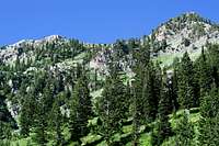
Cherry Creek Canyon is one of three major routes that one can take to ascend Cherry Peak, the fourth highest peak in the Bear River Range of Northern Utah. This route would neither be considered the shortest nor the easiest route. The attraction to this route is that it may see the least amount of visitors. No one should underrate the beautiful scenery of this route, either. It holds is own when it comes to natural wonder. Also, for those who like to give mountains their due, this route dictates the most elevation gain of all three routes. Cherry Creek Canyon stands ready to challenge the most spirited hikers. Adventure and rewards await you in this pristine canyon of the Mt. Naomi Wilderness Area.Trail Length: 4.58 miles
Trailhead Elevation: 5,800 feet
Cherry Peak Elevation: 9,765 feet
 Mt. Naomi Wilderness
Essentials
1) No toilets or running water are at the trailhead
2) Cherry Creek has plenty of running water
3) Map and compass
4) Sturdy hiking shoes
Getting There

As already mentioned on the main page, the access to this trailhead is reached from the town of Richmond, UT, which reached from US Highway 91. Once at the town of Richmond, turn east on to Main Street. Follow this road for a few blocks until you reach Third Street East. Turn left onto Third East so you will be heading north. Eventually, you will find Fifth Street North. This is also Cherry Creek Canyon Road. From here you will follow the road all the way to the trailhead. The road can get pretty narrow, as it will seem like you are driving through a tunnel of brush and trees at times. Most cars with decent clearance can probably navigate this road without trouble. The dirt road only plunges into the canyon a couple of miles before you reach the end of the road.
 Cherry Creek Canyon Road
The parking is not very good. There will be a point where the road will cross through Cherry Creek. Before it does this, there will be a small cutout in the brush on the side of the road. It would be best to park in this cutout. There is probably only room for one vehicle. Although the road does continue beyond the Cherry Creek crossing, it doesn’t go much further and just abruptly ends, without a good place to turn around. A large pickup might have trouble here. There is not a parking lot at all where the road ends. If the cutout I already suggested is taken, you will just have to find the next available cutout down the road. Or you could cross the creek and drive to the end of the road, and hope that nobody else comes and traps you in. But, without any other attractions besides the trailhead in the canyon, there shouldn’t be much of an issue with parking competition.
Route
This is the approximate route:View Cherry Creek Canyon in a larger map
The route basically begins where the roads ends. The trail is a fairly good trail, but can get clogged with vegetation throughout the canyon. All of the vegetation I encountered was human-friendly. The trail is very gradual for the first few miles. It basically follows Cherry Creek up the canyon. There will be seven stream crossings within these first few miles, but you shouldn’t have to get your feet wet. Cherry Peak will only appear a couple of times, and will be mostly obstructed from view because of the trees and the mountain shoulders in the way.
 Cherry Creek Falls
As you approach the base of Cherry Peak, the canyon will bend around to the Southeast. The trail is easy to follow and guides you along your change of direction. Cherry Creek is still flowing strong along this course. You will navigate a few ravines that descend from the west slopes of Cherry Peak. Eventually, you will notice the sounds of cascading water and will shortly identify a beautiful waterfall along Cherry Creek. The trail never gets too close to the falls, so take advantage of the one spur trail that takes you to a nice overlook of the falls, still a few hundred feet away. If you want a closer look, you’ll have to do some trailblazing.
 End of the Canyon
After you pass the falls, the creek shortly becomes silent and the creek bed will be dry. You will notice that the canyon levels out in the middle and creates a beautiful meadow area. I suppose campsites could be found in this area. Not much longer after this, the canyon comes to its head. At the top of the canyon and toward the end of the meadow, the trail will begin to scale the west slopes of Cherry Peak. You will find a few switchbacks along the way and then the trail will turn northward as it ascends the southern ridge of Cherry Peak. Once the trail reaches the ridge, it crosses to the east side of the mountain just before Peak 9490 would be reached. From the top of the ridge Cherry Peak is clearly visible. Any route-finding from this point could be accomplished without any difficulty. This author continued along the same trail, which heads toward a rocky ridgeline, which extends to the southeast from the peak. The trail will lose some elevation and then regain it as you make your way to the ridgeline.
 Peak 9490 and Trail
Once you reach this rocky ridge, the final ascent is right in front of you. You can leave any extra weight behind on these rocks, as the incline can be intimidating. You can make out a few faint trails that creep up the summit, but nothing really substantial is apparent. The ascent is steep, but no scrambling should be necessary. Just don’t loose your balance, or it will be a long fall.
The summit is easy to find. There is no register, except for the graffiti left behind by less conservative hikers. From the summit, you will be able to see most of the major peaks of the Mt. Naomi Wilderness Area, including Naomi Peak, as well as all major peaks of the Wellsville Range, as well as the high peaks of the Malad Range. You will be able to see a few major drainages that surround the peak, including Cherry Creek Canyon, South Fork High Creek Canyon, and Smithfield Canyon. High Creek Lake is also seen from the top. A large section of the Cache Valley is also visible.
 High Creek Lake
The return route is just the opposite. Remember that if you follow the same route, you will loose some elevation, and then ascend again to regain the ridge before you drop back down into Cherry Creek Canyon… and you thought the climbing was over. Hehehe.
Peaks, Data and Maps
Besides Cherry Peak, two other peaks without their own SP pages can be accessed from this canyon. These are Prater Mountain and Cougar Mountain. Prater Mountain
Prater Mountain can be accessed from a side canyon (north) of Cherry Creek Canyon. The author did notice the trail that departed from the main trail up the canyon that could take you to Prater Mountain. The author did not travel this trail and so cannot give any more information about it, other than it is marked on the USGS map.
 Cougar Mountain
Cougar Mountain or City Creek Peak could be climbed after ascending the same southern ridge of Cherry Peak at the top of Cherry Creek Canyon. After ascending the ridge, traverse toward the Cougar Mountain ridgeline and begin ascending the mountain. The author did not notice any trails that went off in this direction, but route-finding shouldn’t be difficult. The ridge that follows up Cougar Mountain looks like a very steep incline, but could be done with diligent effort.
Cherry Peak:
Elevation: 9,765 feet
Prominence: 705 feet
Isolation: 1.35 miles
Utah Rank: 481
County Rank: 4
County Prominence Rank: 19
Range Rank: 4
Range Prominence Rank: 12
Prater Mountain: 9,384 feet
Cougar Mountain: 9,343 feet
USGS Maps:
Naomi Peak, UT-ID – 1:24,000
Logan, UT – 1:100,000
Flora
Here's a few wildflower samples. Enjoy! Coville's Columbine
 Wild Geranium
 Indian Paintbrush
 Woodland Saxifrage?