
|
|
Mountain/Rock |
|---|---|
|
|
41.92318°N / 111.69669°W |
|
|
Cache |
|
|
Hiking, Mountaineering, Trad Climbing, Mixed |
|
|
Spring, Summer, Fall, Winter |
|
|
9765 ft / 2976 m |
|
|
Overview
Cherry Peak (also known as Cherry Creek Peak) is probably one of the more dramatic peaks in the Bear River Range because of the 700+ ft. vertical drop on it's North Face and it receives its name from all the wild choke cherry trees that grow near Cherry Creek. From the West it appears to be a near perfect pyramid and from the North a giant wall of rock. It is the third highest officially named peak in the Bear River Range and the fourth actual highest. (Bullen Hole Peak is higher at 9,828 ft. but the name is unofficial.) It is one of the few major peaks in the range that lie completely within the Mt. Naomi Wilderness Area and it lies about a mile Northwest of Naomi Peak itself. High Creek Lake is at the base of the mountain on the east.Cherry Peak is most visible from Richmond, Utah as the town is situated directly in the mouth of Cherry Creek Canyon. It is difficult to see from other areas in Cache Valley because Prater Mountain blocks the view to the North and City Creek Peak blocks it on the South. It is not visible from the Bear Lake Valley to the East as it is situated on the Western side of the range.
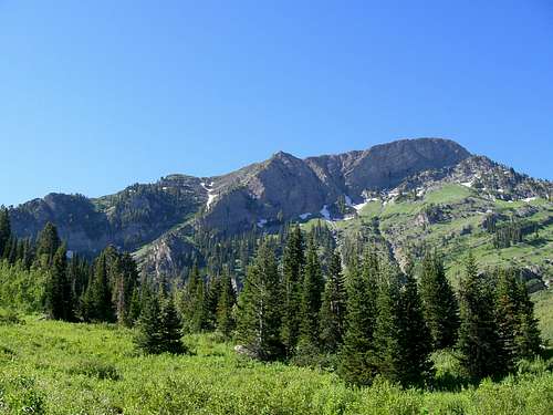 The North face of Cherry Peak
Any approach to the mountain will be challenging and fun. Some routes are more difficult with regard to time, length, and technicality. The North face could offer some fun class 4-5 climbing and would be one of the few peaks in the range to offer a climb of that difficulty. The other approaches would be in the class 2-3 range.
Getting There
There are 3 different approaches possible to this peak.Tony Grove Trailhead
From Logan, Utah take 400 North which turns into US 89 and goes through Logan Canyon. Turn off the highway when you get to the Tony Grove Lake road and drive to the parking lot/trailhead at the end of the road. Follow the Naomi Peak Trail up over Naomi Peak and continue to follow the trail past it. Cherry Peak will be visible to you directly ahead of you from this point. You will lose about 800 ft. of elevation going down into the pass between Naomi and Cherry Peak. The pass is just above High Creek Lake as well and will start to climb up the South side of Cherry Peak to the West of the lake. The trail will lead to a ridge about 300 ft. below the summit (pt. 9400). Leave the trail and follow the ridge to the top from here.
Total Distance: 4.42 miles
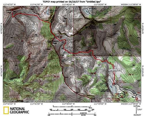 The Tony Grove Route
High Creek Trailhead
Drive North on US 91 to Cove, Utah and turn off the highway at the High Creek sign. Drive to the end of High Creek road to the parking lot there. Then follow the High Creek Lake Trail (also called the South Fork High Creek Tral) to the lake. The trail continues on past the lake and joins the trail coming over from Tony Grove. From there use the same route as the Tony Grove trail.
Total Distance: 5.86 miles
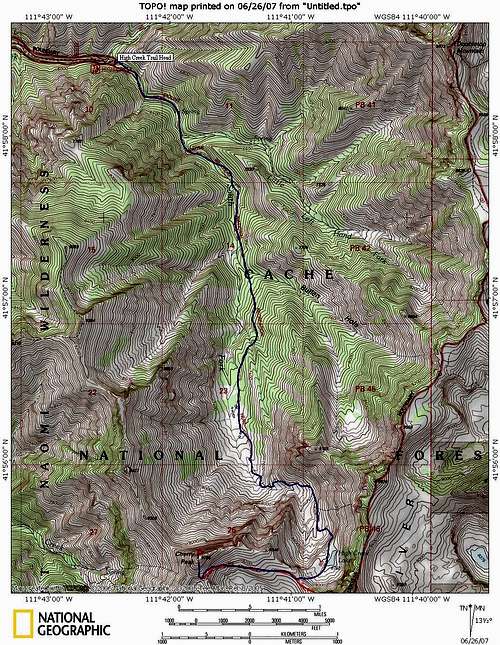 The Route from High Creek
Cherry Creek Route
This is probably the most wearying of the three approaches as it starts at about 5,800 ft. and climbs to the top at 9,765 ft., an elevation gain of nearly 4,000 ft in less than 5 miles!
Drive from Logan North on US 89 to Richmond, Utah. Turn onto the main street of Richmond and get on 500 North. This turns into Cherry Creek Road and follow it til it ends at the trail head. Follow the trail all the way to the back of the canyon where it will start climbing to the ridge South of the peak. (9,400 ft.) Leave the trail on the ridge and scramble your way to the top.
Total Distance: 4.58 miles
 The route fro Cherry Creek.
Red Tape
 Prater Mountain, Cherry Peak, and City Creek Peak
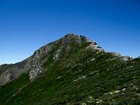 Cherry Peak from just below
You will want to bring plenty of water and a water filter as well because there is water available at some point on each of the routes. Sometimes the water dries up in exceptionally dry years. High Creek Lake is always full though. (And COLD!)
Camping
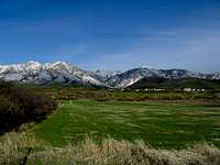
 Cherry Peak from Naomi Peak