
-
 5495 Hits
-
 78.27% Score
-
 9 Votes
|
|
Route |
|---|---|
|
|
43.91404°N / 109.30303°W |
|
|
Hiking, Mountaineering, Scrambling |
|
|
Summer |
|
|
Most of a day |
|
|
Class 3 |
|
|
Easy to moderate scrambling and snow |
|
|
Overview
This is a moderate day outing that allows you to visit four summits: Chief Mountain, Point 11,930 (the highpoint of Galena Ridge), Point 12,104, and Brown Mountain. Most of it is Class 1 and 2 hiking, but there are sections of Class 3 on the north face of Chief Mountain and the east ridge of Point 11,930, and there is the potential for snow travel in some places as well. Not counting the road hike between the two trailheads, more than half the road is above treeline, most of that a journey along alpine ridges and meadows. This means the scenery is amazing but also that it is a bad place to be if the weather goes bad. Start very early, and if sky conditions look threatening, turn back; you’re just too exposed, and for too long, on this route.Getting There
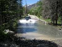 Yours truly plowing through the Wood River-- photo by musicman82.
High clearance is necessary, and 4wd is a plus. It is advisable to get out and check stream crossings before plowing through them.
Remember that odometers can very slightly. In two different vehicles, I have gotten two different measures here, but both were within a mile of each other.
From Meeteetse, 32 miles south of Cody, turn west onto the signed road for Wyoming 290. In 6.4 miles, turn left onto Wood River Road. At 11.6 miles, the pavement ends. The national forest boundary is at 21.7 miles. Pass Wood River Campground at 22.4 miles and Brown Mountain Campground at 24.8 miles. The road now gets a little rougher, but it is not real 4WD stuff. At 26.8 miles is the first of three stream crossings, at Jojo Creek. This one is short and usually shallow. The second river crossing (Wood River) is at 27 miles. This one is wider and deeper. The third crossing (Wood River), which is actually two crossings in quick succession, is at 29.3 miles. These are broad but shallow. The trailhead for Meadow Creek is at 30 miles, on the right (north) side of the road. As of July 2010, there was a rusty metal sign marking the trailhead.
You can continue past this point for four miles to the trailhead and old townsite of Kirwin. There is one more stream crossing, of a stream draining Brown Basin, just before the trailhead, but it is a tributary stream and may even be dry. It takes me about 75 minutes to make the drive to Kirwin.
Conditions can change. In 2010, there were water crossings that were not there during my visits in 2001 and 2007. In one spot, the stream and the road were the same for about a quarter-mile. Be prepared for a driving adventure.
It's a long drive in. It would be wise to check with the local ranger district about any access restrictions before heading in. Call 307-868-2379 (Meeteetse Ranger District).
Route Description


I did not GPS the route, but it is about 11-12 miles, not counting the four road miles between Kirwin and Meadow Creek Trailhead. The lower trailhead is at 8300’ (upper is 9200’), and the highpoint of the route is 12,161’, but overall elevation gain is really approximately 4600’.
If you are shuttling, it makes sense to start from Kirwin. That will save 900’ of elevation gain, and it will also get you above treeline faster (1.5-2 mi as opposed to 3).
If you only have one vehicle, you will probably prefer to start from Meadow Creek Trailhead. That will allow an easy downhill finish as you walk down the road from Kirwin back to Meadow Creek Trailhead. My climbing partner and I did the route that way, and that is the way I describe it here.
From the trailhead, hike three moderately steep miles (8300-9900’) until Meadow Creek Basin opens before you. This basin is simply beautiful, and even jaded climbers bored by trail scenery after what they have seen from the mountaintops will admire this place.
As you enter the basin, the trail turns right to cross the stream in order to avoid a massive boulder pile. Although you can cross the stream and climb Chief Mountain from higher in the basin, the fastest and most direct route is via that boulder field. Clamber up it, study the slopes above, and choose what way best suits you. You can keep it at steep, often-loose Class 2, but there are also many sections that offer sustained, enjoyable Class 3 and 4 scrambling. As I have said many times, I prefer a climb to a slog, so I did as much scrambling as I could.
Above the good scrambling sections, a summit appears just to the left and a couple hundred feet up, but that is not the actual summit, so do not head for it. Instead, attain the ridge crest to its right and then make an easy finish right (southwest) to the real summit, where there is no register.
 Route up Chief Mountain Route up Chief Mountain |
 Summit of Chief Mountain Summit of Chief Mountain |
 Route from Chief Mountain Route from Chief Mountain |
From the summit, hike down to the saddle between the peaks and then head up to Galena Ridge’s crest. There is some brief but enjoyable Class 3 terrain just below the crest.
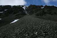
 Galena Ridge highpoint
Now, hike down to the saddle to the west and then hike up to the summit of Point 12,104. The slopes are steep, but there is nothing difficult to negotiate. If snow is present, an ice axe will be useful, especially if it is still early enough in the day for the snow to be hard.
If you don’t feel like going up Point 12,104, it is easy to angle southwest from the saddle and gain the ridge south of the summit. That is what we did, and we used our axes to help us cross the large snowfield that was present on the eastern side of the ridge.
From Chief Mountain to Point 12,104, the distance is 1.5-2 mi.
 Route to Brown Route to Brown |
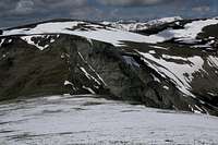
 Point 12,104 Point 12,104 |
 Me going up the snow-- photo by SP member musicman82. Me going up the snow-- photo by SP member musicman82. |
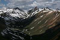
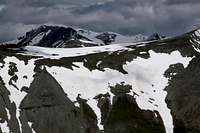
From here to Brown Mountain, it is just a walk along the tundra. In my opinion, this stretch has the best views of the route. You can see north to Francs Peak, the range highpoint; massive Mount Crosby dominates the scene to the southwest; and to the west, a sea of rugged peaks, most of them nameless, unfolds. This is Absaroka high country at its best.
The distance from Point 12,104 to Brown Mountain is 1.5-2 mi.
 Views en route... Views en route... |
 |
 |
From the summit of Brown Mountain, travel the ridge southwest to pinnacle-studded Greybull Pass, one of the best trail destinations in the Absarokas. It’s a Class 2 descent, but you may get into a little 2+/3 in one spot.
It is three steep trail miles from Greybull Pass to Kirwin, more than half of it still above timberline, and four miles from Kirwin down to Meadow Creek Trailhead.
 Absaroka splendor