
-
 4172 Hits
-
 76.66% Score
-
 7 Votes
|
|
Route |
|---|---|
|
|
45.99349°N / 11.47157°E |
|
|
Hiking |
|
|
Summer, Fall |
|
|
A long day |
|
|
Quite demanding bike up, easy hike up |
|
|
Overview
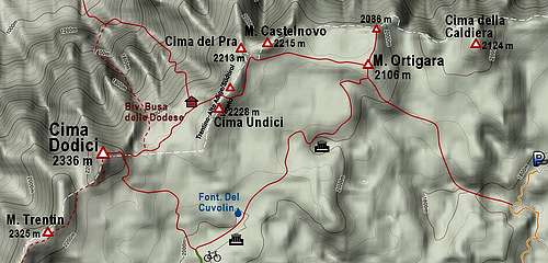
Among the southern ascents on Cima Dodici, this is one of the longest ones. But due to ex military roads which cross the slopes of Cima Portule and the high plateau below Cima Dodici I can recommend it as one of the most interesting ones. The recommendation would of course be - do it as a bike & hike tour. With a mountain bike you can do one way some 14 kilometers, in the return you can use the same route or an even 7 kilometers longer southern variant. If you extend the hike up on Cima Dodici also with the visit of Monte Ortigara, you get a long one day tour where the sum of all altitude gains will approximate to as much as 1800 meters. The tour is very interesting also because of many remains from the World War I - so reserve quite some time to explore them as well.Basic Data
| The tour by sections. Malga Larici di Sotto - Bocchetta Portule - Bivio Monumenti - pass 2055 m - Bivio Italia - crossroads 1900 m - Cima Dodici - bivouac Busa delle Dodese - Monte Ortigara - Bivio Italia - Malga di Galmarara - Bivio Monumenti - Bocchetta Portule - Malga Larici di Sotto. Getting there. See the main page of Cima Dodici how to reach Malga Larici di Sotto. We can park (or even sleep in car or tent) above the meadow. Start. Malga Larici di Sotto, 1625 m. Highest point. Cima Dodici, 2336 m. Total time (using mountain bikes): 10 h 30 min. By bike: 34 km. Hike: 4 h. Difficulty of biking: In some places high, roads are rugged, decayed, steep in some places. Difficulty of hiking: Easy - by the Swiss Hiking Scale it would be T2. Best Season. Summer and autumn, approxiatelx from June till October. When days are becoming short, consider shortening also the tour. Other interesting items. Remains of World War 1. Shortened tour 1. The same as described, but we only ascend Cima Dodici and return to bikes. Then by the ascent road back. 6 h 30 min to 7 h. Shortened tour 2. The same as described, we do the whole hiking round tour (also on M. Ortigara), but we bike back by the same road. Some 9 h. Extention. If we have two cars, we can leave the second one in Asiago and return by the SE approach - via Campomulo and Gallio, more or less only riding down. | View Cima Dodici 2 in a larger map |
Route Description
View Cima Dodici in a larger map |
From the place where above Malga Larici di Sotto, 1625 m, the road is closed for public traffic, you continue by the road first towards the NE, then SE. The ex military road is very panoramic, but on some places stony, rugged and decayed. Beyond Val Renzola it descends on one place for some 30 meters, the last part to the picturesque Bocchetta Portule, 1937 m, is steep and very strenuous. 1 h 30 min.
 Above Malga Larici |  reaching Bocchetta Portule |  Reaching Bocchetta Portule |  On Bocchetta Portule |
 Leaving Bocchetta Portule |  Bivio Monumenti |
 Monument above Campo Gallina |  Campo Gallina from above |  Guarding |  Above Campo Gallina |
 On Campo Casara |  On Pass 2055 m |
 Biking down from Pass 2055 m |  Cima Dodici from Bivio Italia |
 From Cima Dodici towards the E |
 Cima Dodici E slopes |  At the bivouac |
 Ravine |  Towards Monte Ortigara |
The first 1 km of bike return goes up some 50 meters, until we reach again Bivio Italia. The shortest return would be by the arrival road, but we can explore some more places. So we descend from the saddle first towards the SE, on the next crossroads keep right and keep riding down towards the south. Even if the road is not very steep, it is still rugged on many places, so ride carefully. After Tre Fontane house the road does two big turns, losing a lot of altitude. Then we continue towards the S, after some more steep turns we are soon down on the important crossroads of Malga di Galmarara, 1611 m. 45 min.
On the big crossroads we choose the rightmost road, starting to ascend again above the huts of Malga. The road is again quite steep, we are already probably also quite tired. Gaining some 100 m of altitude the road reaches Busa del Molton (pasture, hut) and continues ascending towards the SW, around the ridge of Monte Zovielo. We reach the highest point on good 1820 m, where the road in the NW direction turns down. Unfortunately with a few steep turns we again lose almost 100 m, then only the road descends nicely. One more flat up, flat down and tle last flat up to Bivio Monumenti, 1787 m. 1 h 30 min.
From Bivio Monumenti we have to Bocchetta Portule 250 m of a quite steep road. 45 min.
From Bocchetta Portule to Malga Larici the road goes almost entirely down, there's only one ascent of 30 m in the middle. 45 min.
Cima Dodici and its marked paths