
-
 2976 Hits
-
 84.27% Score
-
 18 Votes
|
|
Route |
|---|---|
|
|
46.49190°N / 10.62921°E |
|
|
Mountaineering |
|
|
Summer |
|
|
Most of a day |
|
|
Alpine PD- |
|
|
Overview
Cima Madriccio North Ridge - SW ridge traverse
Cima Madriccio/Madritsch-Spitze 3265 m is located on the long Costiera del Madriccio crossing and belongs to the Ortles-Cevedale Group. It's a minor summit, but despite this it's a worthwhile summit to be uphill, especially from the amazing Val Martello side. In fact this valley offers the possibility of a beautiful and interesting crossing of mild difficulties: the North Ridge - SW ridge traverse.
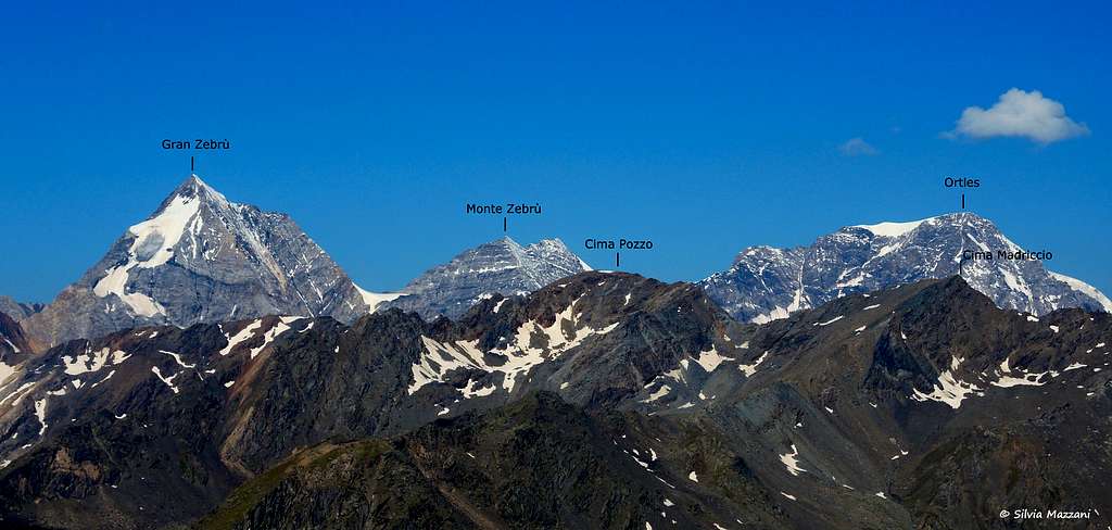
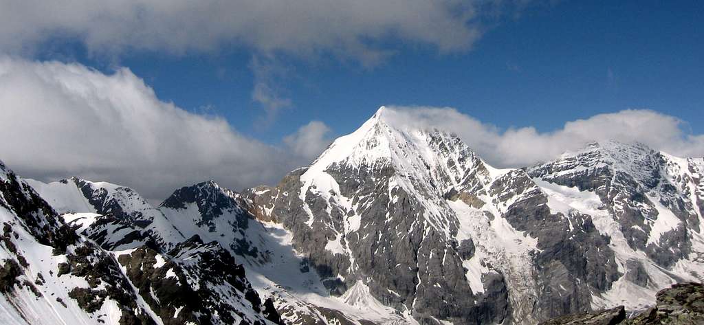
Another great reason to climb this mountain is the breathtaking view over the main peaks of Ortles-Cevedale group, especially Gran Zebrù/Königspitze and Ortles.
Getting There
Road access
The starting point to climb is Rifugio Nino Corsi- Zufall Hutte 2265 m
Coming from A22 Brennero Motorway exit Bolzano and follow the road 38 towards Merano and Val Venosta as far as Coldrano m. 672; here leave the main road turning left and following the road entering Val Martello (Martell Tal) and leading to Paradiso del Cevedale m. 2050, where the road ends (Km. 81 from Bolzano).


Approach to Rifugio Nino Corsi
From the parking lot at the end of the road of Val Martello take a comfortable trail rising gently to the Rifugio Nino Corsi 2265 m, shelter already visible from the parking lot and located on a rocky outcrop (half a hour from the car).
Route Description
Cima Madriccio North Ridge - SW ridge traverse
Difficulty: F+/PD- (Alpine)
Difference in level: 1000 m from Rifugio Corsi 2265 m to the summit at 3265 m


Worthy interesting crossing which involves an easy climb (some moves grading II UIAA) up the North ridge, with stretches of snow, while the descent along the SW ridge is quite easy. From the refuge a good trail on the right enters the Val Madriccio, then it cross the stream and goes up along the left orographic side of the valley, reaching the summit debris basin.


From here we cross the stream again and along steeper slopes we reach Passo Madriccio 3123 m, located between Cima Madriccio on the left and Punta Beltovo di Dentro (Hintere Schöntaufspitze) on the right. A shorter way to get the North ridge may be to follow directly some snowfields on the left of Passo Madriccio without reach the col. From the pass we take a fine and jagged ridge, mostly rocky, with some easy climbing moves alternated with short snowy stretches. In its middle section the ridge has a longer snowy stretch leading to the base of the steeper final step, which we overcome with easy climbing, reaching the large summit cross.


The view is breathtaking!
Descent: from the summit it begins the descent along the obvious SW ridge in the direction of Cima Pozzo, getting easily Passo del Pozzo 3162 m, a col Between Cima Madriccio and Cima Pozzo.

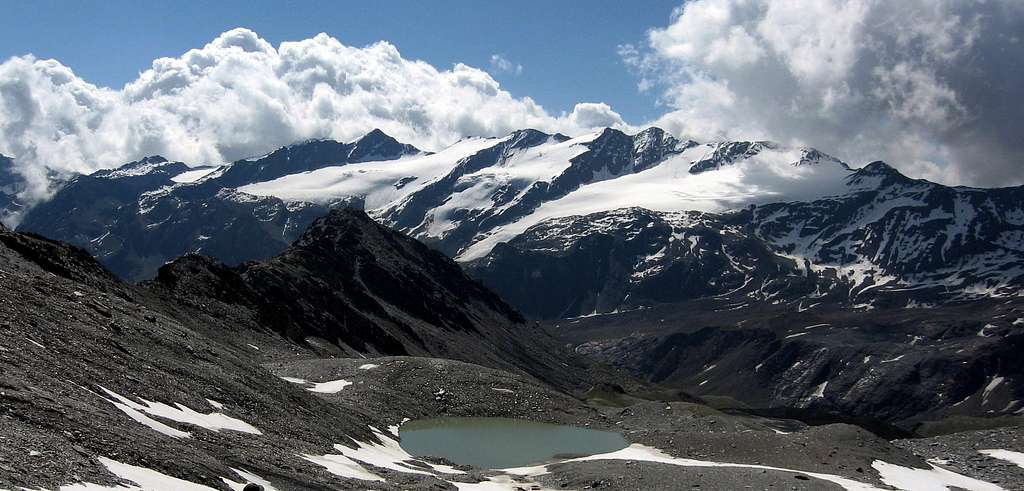
From the col turn to left, following some steep snowfield to enter Valle del Pozzo/Butzental - situated between Cima Madriccio and Cima Pozzo - and follow it, getting an amazing glacial lake with fine views towards the Venezia subgroup (Punta Martello/Cima Venezia ridge just in front).


A last descent leads on Valle del Rio Plima, where you must turn to left along the valley on a well worn trail, leading to the junction with the trail to Refuge Martello and then to Refuge Corsi.
Essential Gear
Rope, crampons and ice-axe
Red Tape

 - Valle del Pozzo")
No fees or permits needed to climb or hike. Cima Madriccio is situated within Parco Nazionale dello Stelvio, one of most important National Parks in Italy.
Hut

- Rifugio Nino Corsi-Zufall Hutte 2265 m
Guardian: Müller Ulrich 39020 Val Martello Alto Adige
Hut Phone: +39 0473 744 785
Mobile: +39 335 630 660 3
info@zufallhuette.com
When to climb
Best season goes from middle June to middle September.
Meteo

Guidebooks and maps


“Ortles-Cevedale – Parco Nazionale dello Stelvio” by Gino Buscaini – Collana CAI-TCI Guide dei Monti d’Italia
Map
Ortles - Cevedale Tabacco, foglio 08, 1:25.000