
|
|
Mountain/Rock |
|---|---|
|
|
46.38779°N / 11.59991°E |
|
|
Scrambling, Via Ferrata |
|
|
Summer |
|
|
8140 ft / 2481 m |
|
|
Overview
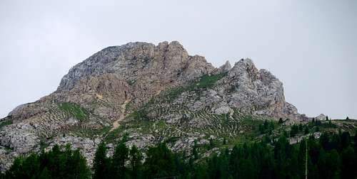
Cima Popa 2481 m
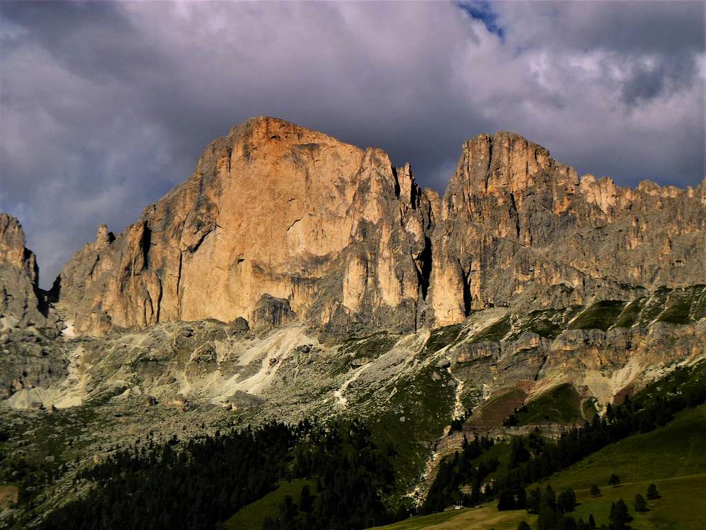
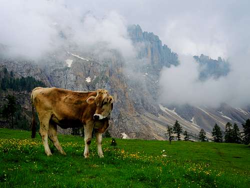
Cima Popa 2481 belongs to the Latemar group and is a minor summit, nevertheless it is a peak that deserves to be climbed also in reason of the view over the Catinaccio group with the famous red wall of the Roda di Vaèl, just in front. The Latemar is a Dolomite mountain group extending between the provinces of Trento and Bolzano, in fact the ridges of the Latemar peaks just form the border between the two provinces.
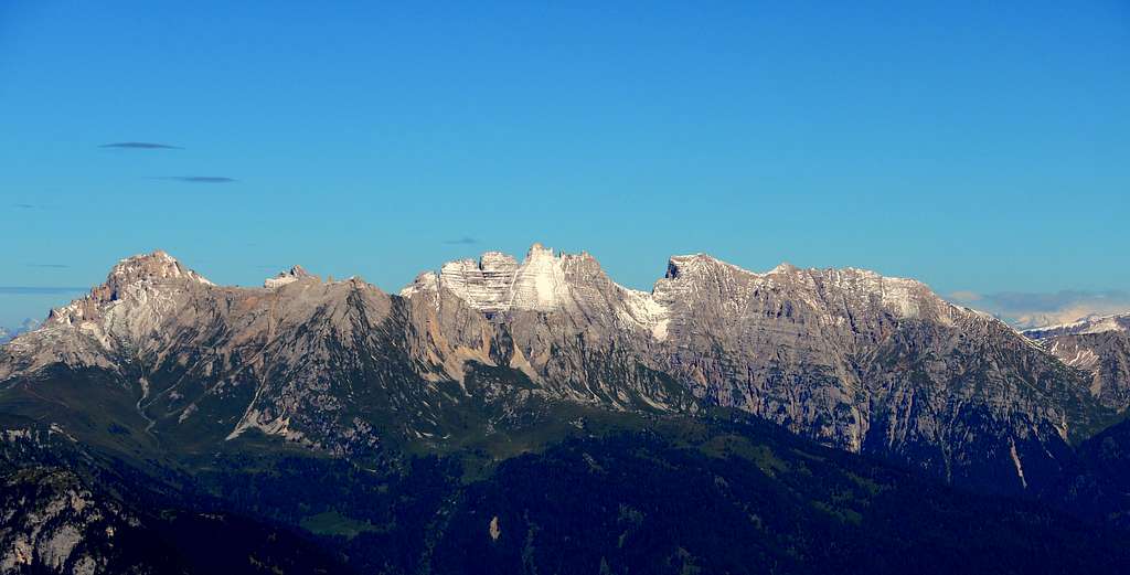
Cima Popa is the culminating peak of the steep rocky ridge called "Le Pope" which closes the Latemar group to the N towards the Costalunga Pass. The starting point to climb this little-visited peak is the Passo Costalunga, a pass connecting the Val di Fassa with the Val d'Ega, known in reason of the cool Lago Carezza, situated in the vicinity.
Getting There
From Egna-Ora (exit of the Brenner A22) take the road to Val di Fassa and go up to cross the Passo di San Lugano, from where you enter Val di Fiemme. Going up the valley to Predazzo, continue along the Val di Fassa reaching Vigo di Fassa, from where you turn left to reach the Costalunga Pass (1743 m, 62 km from Egna-Ora);
Normal Route
Cima Popa from Passo Costalunga
Summit quote: 2481 m
Difficulty: F
Difference in level: 730 m
Starting point: Passo di Costalunga 1743 m
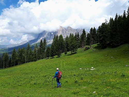
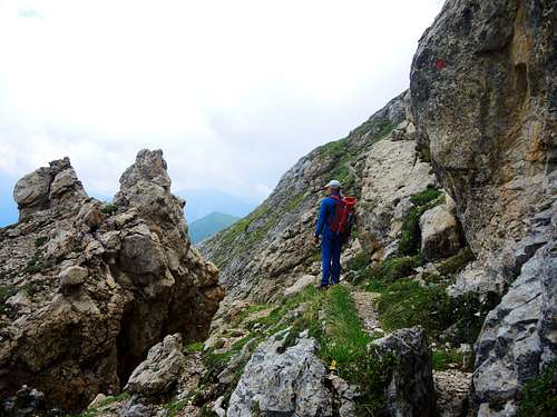
From Passo di Costalunga, separating the Catinaccio and Latemar groups, take an obvious dirt road (closed to traffic) that starts behind the Hotel Antermònt, going through the meadows descending from the Latemar massif (trail n. 17, signpost "Il Pulpito"). Reached a fence, follow the right path which flattens among the meadows, passes next to a ski lift and enters the dense forest. When you reach the edge of the wood, pass a small gate and enter the clearing of the Prati del Latemar 1840 m. This is a pasture plateau located on a ridge descending from the Cresta delle Pope, which are clearly visible beyond the wood. On the opposite side, beyond the Costalunga Pass, the peaks of the Vaèl Subgroup, part of the Catinaccio Group, emerge with the beautiful Red Wall of the Roda di Vaèl.
At a crossroads ignore the path n. 18 to continue on n. 17 which, after having climbed the edge of the wooded ridge for a short distance, bends left again, passing high again on the Latemar meadows. Returning to the slope overlooking the Costalunga Pass, cross a large ski slope and, with a hairpin bend, reach the arrival station of the ski lift already noticed at the start. Beyond the ski lift, the wood becomes thinner, and the path climbs up with steep hairpins. Once on open ground, the path continues with its hairpin bends, touching a grassy shoulder on which it stands a large antenna.
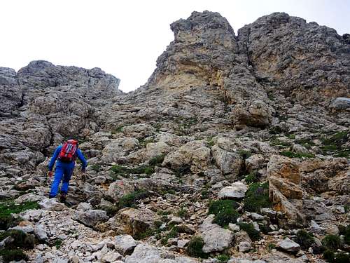
The terrain begins to become rocky and a final stretch of ascent leads to the hairpin bends that lead to an airy collar, immediately to the right of a rocky spike called Pulpit of Cima Popa 2321 m. Easy rocks equipped with a metal rope lead to the top of this beautiful panoramic point protected by a railing. Returning to the col, resume the access path but, from the first bend under the col, you will notice a faint track that crosses to the right (going down) the entire north side of Cima Popa.
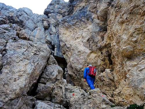
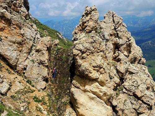
Follow this track which, although it presents no difficulties, is somewhat exposed in some points, up to a rocky gully with a dark earth bottom that drops a few meters. With a short descent reach a safer ground, where the track continues. This leads to a nice terrace overlooking the Moèna valley. From here you have to climb steep grassy grounds up to the base of the band of rocks that supports the summit, and go around it to the right up to a large niche in the rocky wall. This is the key point, a rocky ramp inclined from right to left of about ten meters, which must be climbed carefully (I degree) but, thanks also to the poor exposure of the passage, usually there are no major problems.
On the top of the ramp, a short scree slope leads to large cairns on Cima Popa summit. You can go down to a slender saddle and climb up briefly to the immediately adjacent peak (it is still Cima Popa) from which you can fully admire the bizarre succession of strange towers forming the Cresta delle Pope.
Descent: reversing the same route
Red Tape
No fees no permits required
Hiking and scrambling grades of difficulty
T - Turistico (Tourist): Itineraries on wide, clear and well worn paths, sometimes on mule tracks or gravel roads. The routes are never exposed, don't give any orientation problems and don't exceed 2500 meters of altitude. Suitable also for children.
E - Escursionisti (Hikers): Itineraries on marked trails, even narrow and with possible steep and impervious sections. They are never exposed and don't give any orientation problems. They can tread different kinds of ground, such as forests, gravel, meadows, pastures, easy rocks, etc.). They form the majority of the trails that wind up in the mountains and require a certain habit to walk; you need equipment suitable for the altitude and resistant footwear with soles suitable for rough terrain.
EE - Escursionisti Esperti (Experienced Hikers): Itineraries for hikers with experience and good knowledge of the mountain. Some of these paths may have exposed sections, however brief, which require firm foot and no dizziness. They require the ability to adapt to particular terrain, such as steep grassy slopes or stretches of rocks with difficulties that can reach the 1st degree of the UIAA scale. They can also reach high altitudes (3000 m or more). Sometimes they may include unmarked sections, requiring a good sense of orientation. Snow slopes are possible, however which can be overcome without specific mountaineering gear (rope, harness, crampons, ice-axe).
EEA - Escursionisti Esperti con Attrezzatura (Experienced Hikers with equipment - The same as EE, in addition these routes require the use of via ferrata equipment (lanyards, harness, carabiners, heat sink, helmet). This kind of itineraries range from the trails with short easy and not much exposed sections, previously equipped with fixed ropes and iron pegs, to the true and more difficult Via Ferratas climbing on rocky walls or on aerial ridges and ledges, previously equipped with long stretches of iron ropes, iron steps, ladders without which proceeding would constitute a real climbing. It is necessary to know how to use the technical equipment and have a certain habit of exposure and mountaineering terrains.
When to Climb
Best season goes from middle June to the end of September
Where to stay
Different possibilities in Val di Fassa and Passo Costalunga
Bibliography
"Latemar - Val d'Ega " Kompass map sheet 630 1:25000
Meteo forecast