-
 9883 Hits
-
 74.92% Score
-
 5 Votes
|
|
Route |
|---|---|
|
|
45.72682°N / 10.84312°E |
|
|
Hiking |
|
|
Spring, Summer, Fall |
|
|
Most of a day |
|
|
Easy walk up |
|
|
Overview
When ascending on Monte Baldo massif, it is certainly the best to plan a long crossing. While walking comfortably, you will be able to enjoy the widest possible panoramas or the abundance of flora in this "Garden of Italy". The plan, and I believe a very good suggestion, would be:Drive by a mountain road till the highest parking place above Prada, cca 1300m. Perhaps sleep there. Leave bikes on the parking place and drive early in the morning down to Garda lake and to Malcesine cable way. The cable way brings you up on the main ridge, 1745m. Then go southwards all the way by the ridge. Ascend as many elevations you wish, and certainly the highest one, Cima Valdritta. After descending to the parking place you only bike down to Malcesine. If a clear weather, you will remember that day!
As we couldn't do the proposed tour, here is only the description of the route over the southern part. The northern part is described here.
The tour is mostly an easy hike up. On the upper part there are a few rocky passages, but the path is wide enough and requires just the usual hiking concentration. Gear: Good shoes and poles.
Getting There
Prada village lies good 900 meters high, above the eastern shore of Garda lake. From the lake shore you can drive there from a few places, the most common road is the one from Torri del Benaco. The village can be reached also from the southern or eastern side, from the valley of Adige. In that case you will drive through Caprino Veronese.South before Prada, a mountain road deters towards the east. It is narrow, but well maintained and asphalted. The road is closed for public traffic on some 1300m, where there's a big parking place. Roads, which go further on towards the ridge are more and more narrow and rugged, but can be done by a mountain bike (as high as you wish - till almost 2000m) and also authorised locals drive there with 4WD.
Route Description
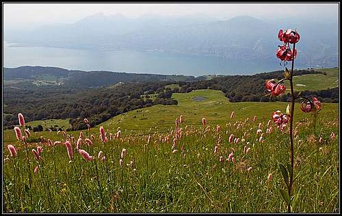
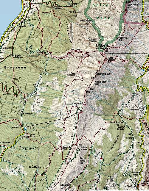
From the parking place we continue by the road northwards, following the path marks No. 51. On the first crossing we deter right and follow the path No. 655 till below the main ridge, where we hit the moutain road again. We are out of the woods, on the place where the beautiful grassy Costabella ridge starts. In early summer it is full of blossoming flowers, a true "Garden iof Italy". The road goes just below the ridge, but we can also ascend the ridge and follow the path there. Nearby is ex Forte Naole (fortress). By Costabella ridge we comfortably reach Rifugio Chierego, 1911m. Till this point you can also take a chair-lift, the bottom station is down in Prada. So, it's understandable that in a nice day this part of Monte Baldo ridge is very crowdy. But enjoy the scenery, flora and the view town to Garda lake.Just above Rifugio Chierego there's the grassy summit, called Coal Santo, 2072m. If you can't wait ascending the first higher summit of Monte Baldo, you can cross it, otherwise two marked paths go around it (by the east and west), so you'll probably continue by the western cart road around it and reach on the other side Bocchetta di Coal Santo. A broad path continues from there towards the north. Next is Passo del Camino, 2128m, after which the broad path switches on the eastern slopes of the main ridge. Through an attractive scenery of rock towers we continue below the summit of Vetta delle Buse, 2154m, and reach the saddle below Punta Sascaga, 2136m. This summit can again be detoured by the eastern or western side (or can be scrambled over the top), the western path brings us directly to the big Rifugio Telegrafo, 2147m. Just above it is another big summit of Monte Baldo massif, Monte Maggiore, 2200m.
From below Monte Maggiore (south of the summit) the main marked path (No. 651) descends a bit on the eastern side and then continues towards the NE, towards Cima Valdritta. The path crosses the slopes below Punta Pettorina, 2192m, then turn more towards the N direction and reaches Forcella Valdritta. There the path No. 66 comes up from the east (the shortest ascent on Cima Valdritta). On the notch just south of Cima Valdritta, there's another important crossing. One path goes across the ridge and descends on the western side (No. 5), one path continues crossing the slopes towards the north (No. 651), while we follow the third (middle) path, ascending directly up on Cima Valdritta. It's less than 10 minutes to the top, the path is well carved, but a bit more steep.
Depending on your logistic, there are several options for a descent.


