


Elizabeth Riggin - Nov 2, 2008 9:26 am - Hasn't voted
A 45 degree slope...I liked your report and found it interesting...the photos are nice as well.
Take care,
Liz

vancouver islander - Nov 2, 2008 10:19 am - Hasn't voted
Re: A 45 degree slope...thanks for reading my report Liz. Glad you enjoyed it. Cheers. Martin

oconnellr - Nov 3, 2008 12:59 am - Hasn't voted
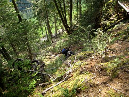
great TRGreat trip report - that initial steep slash section looks hideous. I need to get out and do some routes to get the real Island bush experience I think. Interesting history too. Thanks for sharing.
Cheers,
Rory
vancouver islander - Nov 3, 2008 1:11 pm - Hasn't voted
Re: great TRThanks Rory. We missed you on yesterday's hike.
Yes, the Island bush experience is something you need to get into. Good for the soul! (Bad for the body).
Cheers, Martin

rpc - Nov 3, 2008 11:24 am - Voted 10/10
great read!"history + seldom visited summit = must-do"
I second that!
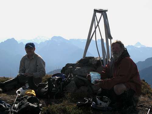
So when were those 7 summit log entries from?
Great write-up Martin!
vancouver islander - Nov 3, 2008 1:19 pm - Hasn't voted
Re: great read!Thanks Radek.
The 2004 group reported the 7 (they were the 8th). The 7 entries were spread over 18 years. I think one year there were 2 and many years none at all.
In the last 4 years there have been 8 ascents including ours, so business is improving. But it's still not a lot. I think that only one person had made the trip a second time.
Interestingly, there was one entry - for 2006 I think - from a solo climber who claimed a time to summit of 4.5 hours from the end of SF900. I have no reason to doubt this. There is a cadre of "speed climbers" on the Island who set out to set these kinds of records. For instance the Golden Hinde record is now under 21 hours car to summit to car. It took this old fart the best part of 5 days. I bet I saw more along the way though.
Cheers,
Martin

imzadi - Nov 4, 2008 2:13 pm - Voted 10/10
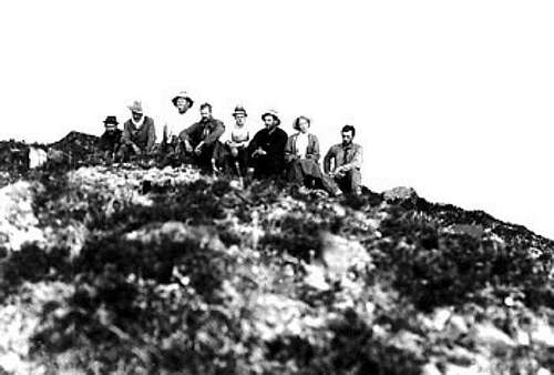
historyLoved the bit of history included...I always wonder about the "history" of some of these climbs.
I second...that steep sections looks horrid...and not very interesting. Downright...ugly actually. But...sometimes you have to go through the ugly to get to the beauty and glory. Awesome views from the top!
vancouver islander - Nov 4, 2008 6:10 pm - Hasn't voted
Re: historyMany thanks for the kind words.
The full history of the mountain is written up in the parent mountain page. I should, perhaps, have referred to this in the TR. If you're interested in learning more visit http://www.summitpost.org/mountain/rock/450835/crown-mountain.html
I have to say that I wouldn't describe the horrid bit as "uninteresting". Survival was very much on my mind during this phase - something I'm definitely interested in :)

camerona91 - Nov 4, 2008 3:23 pm - Voted 10/10
Great!I got to thinking about Crown when I was on King's Peak at the start of September. You don't hear much about it, but it definitely looks like a good destination. 4WD for the approach logging road? Got to love island bush over slash...
vancouver islander - Nov 4, 2008 6:16 pm - Hasn't voted
Re: Great!Good view of Crown from Kings? I really must make the effort to go up there again in something other that the zero vis that has accompanied my 2 visits to date.
You might just get up SF900 with 2WD. There are no cross ditches. The problem is the undergrowth choking the road. Sitting up in a high clearance vehicle is a must in order to be able to see where the road actually goes. Having said that, if you have access to a 4WD, take it.
Glad you enjoyed the report.
Cheers,
Martin
camerona91 - Nov 4, 2008 8:22 pm - Voted 10/10
Re: Great!Coulnd't see the mountain, just the general approach. I saw how high and far the logging roads go and looked at the map a bit, it is definitely on the docket for next year now! Looks like a great fall objective.
vancouver islander - Nov 4, 2008 8:29 pm - Hasn't voted
Re: Great!The approach roads actually go in from the north, so you wouldn't be able to see them from Kings. They also don't go too high.
You probably did see Crown from Kings because we could certainly see the reverse. It's probably that you didn't recognise the south aspect, since all the "classic" views are from the north.
When you head that way, give me a shout and I'll send you a GPS tracklog. That'll save you some route finding chores at least.

mvs - Nov 5, 2008 1:24 am - Voted 10/10
You live in a rugged placeAnd are out there experiencing it to the fullest. Right on, and thanks for sharing it!
vancouver islander - Nov 5, 2008 11:16 am - Hasn't voted
Re: You live in a rugged placeC'mon - you're a N Cascades man - you know what it's like here :)
Don't get too spoiled over there by all those gondolas and huts with comfy beds and meals laid on etc.
Many thanks for reading my report and your always welcome comments. And keep those great reports of your own coming.
Martin
mvs - Nov 6, 2008 5:29 am - Voted 10/10
Re: You live in a rugged placeYeah, I just think it's neat how for Vancouver Island you often need multiple days to get in to the interesting stuff. With the exception of the Picket Range and maybe the Olympics, the Cascades are a bit easier. And okay, I'll try not to get soft, just let me finish this wonderful slab of Strüdel mit Sahne und Vanillasoße. :D

suddendescent - Nov 9, 2008 6:31 pm - Hasn't voted
Fabulous !I found the adventure thrilling ! Furthermore I discovered a little mor eof Canada ! Imagine, I didn't even know there were such mountains on Vancouver island !
As for some unknown mountain scenery closer to where I live, one guy from Vancouver told me aboutthe Groulx hills.. Unfotunately I can't find any pictures of them. I did post a satellite image of them on my profile page...
vancouver islander - Nov 9, 2008 8:10 pm - Hasn't voted
Re: Fabulous !Many thanks - so glad you enjoyed the story.
Yes - there are indeed many such mountains on the Island. The Alpine backbone stretches almost 500 km from the Cowichan Valley in the south almost to Port Alice in the north. You'll find TR's and mountain descriptions of many of them under my profile. Just click on "vancouver islander" and browse away.
Cheers,
Martin

WoundedKnee - Nov 26, 2008 11:09 am - Voted 10/10
Man, I wish you would stop writing trip reports...It makes it impossible for me to leave Vancouver Island off of my already too-crowded "climbing destination" list.
Cheers
Shannon
vancouver islander - Nov 27, 2008 4:52 pm - Hasn't voted
Re: Man, I wish you would stop writing trip reports...:) lol
Thanks Shannon. Sorry but I'll have to keep the pressure on. TR on the obscure Conuma Peak coming soon. A little different this time in that failed by just 30 metres to reach the top - but that, in itself, makes a good story. Should have it up by next week sometime and hope that it tempts you futher to visit our alpine paradise.
Cheers,
Martin
Comments
Post a Comment