

|
|
Mountain/Rock |
|---|---|
|
|
37.76780°N / 119.4883°W |
|
|
9926 ft / 3025 m |
|
|
Overview
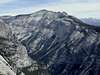
Clouds Rest, a massive granite formation just northeast of Half Dome in Yosemite Valley, is one of the defining hikes in Yosemite National Park (YNP). For casual visitors, it ranks with Half Dome and North Dome as one of the most recommended hikes in the valley and for viewing the valley. Geographically, Clouds Rest lies in the center of nearly every interesting feature in Yosemite. Great views are to be had of Half Dome, the Clark Range in the south, nearly all of Cathedral Range, and even out to Matterhorn Peak and the Sawtooth Range.From Clouds Rest's airy and cozy summit, the most undeniable natural feature is the Northwest Face, a stunning 5000-foot drop into Tenaya Canyon. This is Yosemite glacial geology at its finest. Imagine virgin Sierra Nevada granite, uplifted from its deep burial place by compressional tectonic forces, canyons eroded rapidly by generous spring runoff, and finally, the odd glacier to smooth the slope. Behold: an endless mid-angle slab climb of truly epic proportions! The views of this face from Olmstead Point and North Dome are simply stunning.
There are three primary ways of ascending to the summit listed in order of difficulty:
| |||||||||||||||||||||||||
Special thanks to Morgan who originally submitted this Mountain and provided much valuable information and excellent maps!
 |  |  |  |  |
Getting There
SUNRISE LAKES (TIOGA ROAD) TRAILHEAD (8,160'): This trailhead is on CA SR-120, aka Tioga Road, on the southwest side of Tenaya Lake, 7 miles west of Tuolumne Meadows. There is ample parking here on the side of the road, however, on summer weekends it can get crowded.HAPPY ISLES (YOSEMITE VALLEY) TRAILHEAD (4,105'): This is the main route from the Valley up to Half Dome and can be used to ascend both peaks in one trip. Take the John Muir Trail (JMT) up from the Happy Isles Trailhead in Yosemite Valley. You can reach Yosemite Valley via CA SR-120, CA SR-140, and CA SR-41 which enter the park at the Big Oak Flat, Arch Rock (aka El Portal), and Wawona (aka South) Entrances to the park.
 |  |  |
Red Tape
See the LOGISTICAL CENTER - Tuolumne Meadows page for information on general Yosemite red tape and specific camping red tape.When To Climb
Clouds Rest is typically done in the summer (from Tenaya Lake).The peak can also be done in the winter, however. Take note, though: the winter route is a good deal more arduous- approximate stat's are 22 miles round trip with 6,000' vertical gain. As Tioga Pass is inaccessible for a good part of the year, unless you plan on getting to Tenaya Lake under human power (if you do, I'd love to hear about it!), the most feasible way is as follows:
1. Start in Yosemite Valley from Happy Isles- park at the lot past Curry Village (if planning to do this overnight- & this would be a LONG day'hike'- make sure to get a wilderness permit from the visitor centre in Yosemite Village)
2. Head up towards Little Yosemite Valley (a good site to camp, as there are some good flat camping spots & accessible water), using the standard Half Dome cables approach. The Mist Trail is closed (signs should be posted), so follow the John Muir Trail (JMT). Be on your toes & move quickly- during warm spells, there can be significant rock- & icefall from above en route. From Clark Point there is a demoralizing 300 ft. descent before continuing upwards, skirting Nevada Fall on the L.
3. Continue on towards Half Dome. At the 7,000' level, instead of taking a L to get to the Cables route, hang a right on the JMT.
4. After .5 mile, take another L. Many switchbacks will take you to the base of the Pinnacles (false summit as seen from below). Skirt the base of the prominent dome. This is the steepest part of the route.
5. Once gaining the saddle to the R of the prominent dome, follow the slope to the summit.
It should be emphasized that this is no small undertaking! Variable conditions make this The Full Monty- it is quite likely that lower elevations make snow cover inadequate for snowshoes/skis, while higher elevations will necessitate them. Winter travel/camping experience necessary. After Little Yosemite Valley, few fellow travelers will be encountered- expect solitude & be self-sufficient. Finding the route (largely through the forest where distinguishable landmarks are often obscured) after fresh snowfall can be challenging if others' prior tracks are not discernable (bring a map & compass & know how to use them). Be prepared to evaluate snow stability & make your decisions accordingly at upper elevations. That being said, the area is quite amazing in the winter, the peak will quite likely be yours alone, & views of Yosemite's high country under a blanket of snow is a memory to be cherished!
In the spring, residual ice and snow may make the Sunrise Lakes trail a bit icy, and might play havoc on the well-trodden boulders of Clouds Rest's NW ridge.
Skiing Clouds Rest's northwest face into Tenaya Canyon? Impossible you say? Of course, a guy snowboarded the 40-degree north slopes of Half Dome, so anything is possible- the NW face of Clouds Rest was first officially skied by Jonathan Blair and Jason Torlano on January 16, 2013. Check out this photo of the NW Face on December 18, 2001 from Bob Burd. It looks more than reasonable from the photo ... doesn't it? ;-)
 |
Camping
Wilderness permits are required for backcountry camping. Score your permit at the Tuolumne Meadows permit station. Be forewarned, permits are usually snapped up quite quickly for this area, since the Tuolumne-Clouds Rest-Half Dome-Valley trek is popular. Morgan's wife camped directly on Clouds Rest a few years ago. Truly an unforgettable experience. Try it out if you get the chance!
Mountain Conditions
Check the Official YNP Conditions Update webpage or call 209-372-0200 for the current weather and road closure status. The web page also has a link to the National Weather Service 3-day and extended weather forecast which are published twice daily (4am and 4pm PDT).Also check out the following web cams of nearby Half Dome:
External Links
- Morgan & Kimberly Brown's trip report
July 15, 2000
- John's Clouds Rest Trip Report and Photo Gallery
September 19, 1999
- 3-D shaded relief map
- Half Dome/Clouds Rest dayhike
- Clouds Rest/Half Dome from Sunrise Trailhead
- My Favorite Things IV 5.10a
New route completed in fall 2003.
- My Favorite Things - Rick Booth and Jim Curl - Sept 12, 2004
Finarphin - Aug 16, 2007 10:55 pm - Hasn't voted
Bob KampsNorthwest face route, FA, attributed to Bob Kampas, is actually Bob Kamps.
Diggler - Apr 22, 2009 11:46 am - Hasn't voted
Re: Bob KampsGood catch & completely true- fixed. Need to give the late Mr. Kamps his props, at least getting the name right. Thanks.
steeleman - Jan 17, 2013 6:24 pm - Hasn't voted
skiedthe page hints at the possibility that the NW face of Clouds Rest might one day be skied. Apparently that day was yesterday. http://unofficialnetworks.com/ski-decent-clouds-rest-yosemite-115672/
Diggler - Jan 17, 2013 6:50 pm - Hasn't voted
Re: skiedThanks for the update- updated. WOW!
jartelt - Feb 15, 2018 11:16 pm - Hasn't voted
Additional external linkHere is my trip report describing my hike up to Clouds Rest in 2015. It may be useful to have an update trip report in the external links section of the page. Here you go: https://backpackersreview.wordpress.com/trip-reports/yosemite-hiking-clouds-rest/
Diggler - Feb 21, 2018 8:42 pm - Hasn't voted
Re: Additional external linkHi jartelt, thank you for submitting- I would suggest posting this in the Trip Reports section!