The following is two summaries of two different trips I made inside Arkansas & Oklahoma. The most significant contrast between these vacations lies with me. In the first, centered in Arkansas, I was a novice who was more comfortable in a hotel than a tent. I entered the trip habitually confined to the indoors and left it wanting even more of the wilderness. Three years later, on travels centered in Oklahoma, the outdoors were much more within my element. I was comfortable doing anything and I was not intimidated even by a brutal summer heat wave. However, I left this wilderness in bad shape. In the following weeks, my only desire was the indoors and a cool place to rest.
This was my first real venture somewhere other than the Smokies. I commenced this trip with a long drive to Crater of Diamonds State Park, which lies on relatively flat land just southeast of the Ouachita Mountains. The prospect of digging and searching for gemstones seemed to me a fun one, and I rented some tools from the visitor center before settling in. I eventually meandered about the diamond field, whimsically collecting mounds of tacky mud from random areas that I deemed fit. Getting a little dirty is fine, but working in strikingly cold water at the wash tables was cumulatively too difficult for me to bear. After a few hours, my findings only yielded tiny pieces of ordinary mica without a priceless diamond. Still, I was satisfied with my short foray into amateur prospecting.
After checking out of a Texarkana motel the next morning, my travels took me across the Red River from Texas into Oklahoma. A short distance north of the river, I joined the Talimena Scenic Byway through the Ouachita National Forest. It was an enjoyable drive, particularly at one high overlook where I could see the byway’s track through the forest for miles ahead. The elevation ranged from roughly 1000 to 2500 feet, and the mountains were blanketed by mostly green forests with a few pockets beginning their transition to reds and oranges. After completing the scenic byway, I returned to Arkansas to visit Magazine Mountain, the highest point in the state. Unlike the Ouachita area, the Ozark National Forest terrain surrounding the high point was predominantly low and flat. Magazine Mountain was a massive ridge that climbed to the sky in stark contrast. The potential for far-reaching vistas seemed great and this mountain did not disappoint.
Cove Lake.
Blue Mountain Lake.
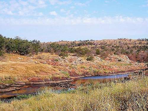
Arkansas panoramas.
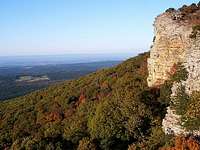
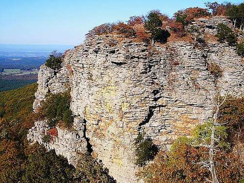
Before enjoying the extended views, I hiked to the actual high point of the mountain on the Signal Hill Trail. There was a neat rock map of Arkansas constructed within the ground there. I collected my own souvenir rock lower on this trail to add to my personal assortment, but I never thought to make a rock map with them. This high point marker gave me a good idea to copy. The crest of Signal Hill was enclosed by forest, so I promptly moved to the edges on the north and south for some more photographs. On top of the cliffs, it felt like the entire state was in reach.
The widespread hospitality and friendliness of the south was in full bloom here. I struck up a conversation with a married couple that was also photographing the seasonal colors. They were actually in the process of creating a time-lapse look at the foliage from summer through fall. I thought it was kind of neat. We continued to chat, and soon I found myself riding in their truck to see a particularly enjoyable view looking southwest from a different point of the mountain. Only in the south will you make friends so quickly. It was a lot of fun. Later, they had to be on their way for the evening, so we exchanged friendly goodbyes and I found a quiet ledge on which to rest and enjoy the gorgeous pink sunset. The spot was a nice resting place guarded by undisturbed brush, away from the easily accessible overlooks. I like to think of it as my personal seat on Magazine Mountain. When the sun disappeared, I turned to my car again for a place to sleep, and I found it at an interstate rest area a few miles northeast.
Magazine Mountain, highest point of Arkansas.
Boston Mountains, Arkansas.
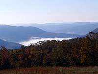
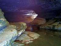
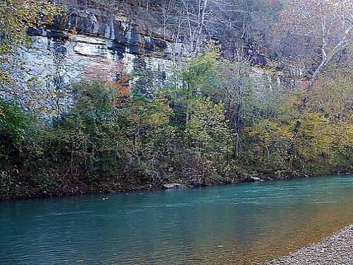
The last day of my trip fell on a Monday, so I was sort of curious to see if my next destination would be totally empty of fellow visitors. I started north on the Ozark Highlands Scenic Byway during the early morning. This was a drive worthy of such a status, particularly at one juncture within the Boston Mountains, where I was treated to the sight of a neat fog inversion inside a low valley. The skies above it were clear and blue. My route took me to the Buffalo National River, a protected area encompassing the river and much of the surrounding land. Logically, I thought I may see the most rugged terrain near the highest reaches of the river, so I navigated a few obscure roads to access an area called Lost Valley. I did not know what was at Lost Valley until I arrived. The trailhead sign also promised a cave farther upstream on Clark Creek, a tributary of the Buffalo River. It sounded sufficient to me, so I loaded my backpack and headed into the forest.
Rock formations within Lost Valley of the Buffalo National River.
The creek was dry and the slope was very slight and ordinary at first. Within a half-hour though, I was suddenly treated to beautiful pools and caves within striking rock formations, as well as a strong uphill grade paralleling a massive rock face. I tried to capture everything with my camera here, but the scale of the rock face hanging overhead was best appreciated in person. After the steep but fairly short uphill section of the hike, I reached Eden Falls Cave, from which emanated a clear rushing waterfall. Without a flashlight, I could only explore the cave so far, so I never ventured far from the entrance. But the view from that entrance, with the fall foliage partially obscuring blue skies and a waterfall cascading to pools down below, was a great backdrop for a break and a snack.
During the hike, I encountered many more people than I expected, although they all seemed to be forest workers doing trail maintenance. Perhaps that explained the fleet of cars in the parking lot, or maybe it was just because this was a special place. Just as I was returning to my car after a couple of hours on the trail, I overheard a local man wondering aloud about how there was an out-of-state tourist here. Since I was arriving at my car with impeccable timing, he went ahead and asked me how I heard about the place, saying that it was one of the state’s best-kept secrets. I showed him my map and just told him I was blindly exploring the upper elevations of the Buffalo National River area. He said I was exploring one of the best places to see, and at the conclusion of my hike, I fully agreed with him.
A beautiful cave and pool in Lost Valley.
Buffalo River tributary inside the forest.
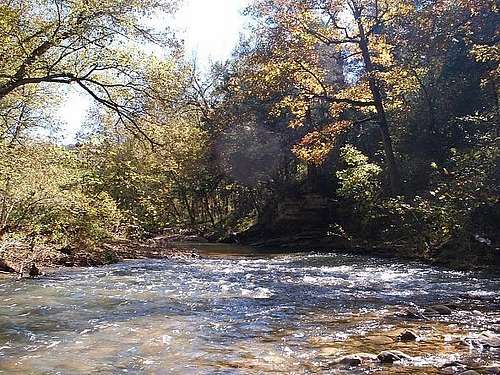
At midday, I needed to begin my trek back home, but I delayed a little longer to visit another section of the Buffalo River at Pruitt Landing. I hiked the Mill Creek Trail out for almost an hour without any map. Once I realized it was not scaling the cliffs beside Pruitt Landing, I hiked back. After some time getting wet in the river under these giant rock faces, I was back on the road for good. This was a very rewarding trip to the Natural State; each natural area seemed to leave even more of an impression upon me than the area I visited before it. Even more so than ever, it left me with the hunger to travel, explore, and find these awesome places hiding in plain sight.
Pruitt Landing on the Buffalo National River, Arkansas.
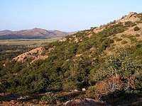
Wichita Mountains, Oklahoma
070112 - 070412
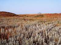
Tallgrass Prairie, Kansas.
Tallgrass Prairie, Kansas.
Black Kettle, Oklahoma.
I was unable to start the first segment of this journey until about 7:30 in the evening. I finished it with about ninety minutes of sleep available until my self-imposed wake-up call for Tallgrass Prairie National Preserve. Later that morning, I reached the preserve a little after 7:00. Tallgrass Prairie National Preserve immediately felt like it was a work in progress. The visitor center was under construction, and as I arrived as the first visitor, a ranger was busy painting the entrance sign. The painting ranger pointed me toward the prairie entrance and I took my backpack and walking sticks that way.
Immediately upon beginning my inquisitive hike, I strengthened my growing impression that I was an uncustomary tourist for the area. The hiking “trails” outlined on my map were undeniably roads for the preserve’s touring buses. The rolling prairie hills were dotted with grazing cattle and little else. I left the roads instantly to wander freely across the prairie heading west. Much to my surprise, I discovered how thoroughly the tall grasses are littered with limestone rocks. There are no outcrops or overt formations, just small bits of limestone that occupy the ground like white chocolate chips on a cookie. The only trees visible here are far on the horizon, more than a day’s hike away. It is not perfectly flat, although the small hills are very subtle. At this time of summer, most of the endless grass reaches to my knees or waist, and it is not as vividly green as it can be in the spring. I get a wide open feeling of freedom here, even without a true wilderness experience among cattle herds and a random pass of a tour bus. I continued to avoid the trails (roads) as I moved on a wandering line around a snake and a pond toward the highest hill within the preserve.
Near the high point, I had to cross in front of a cattle herd that, at first, caused me no alarm. However, as I walked north along one of the numerous small crests in the hills, a half-dozen longhorns suddenly appeared from the swell on my right. They were apparently spooked by our sudden close proximity, because they began to run straight ahead, and I was directly in their path. As a habit with animal encounters, I tried to maintain the fine balance between getting away from them and also behaving casually without panic. It was honestly a tense few seconds. Only the few steps I had taken in those seconds separated me from the herd. I was much more attentive to the cattle from that point onward, and I kept greater spaces behind me and the animals. Consequently, my walk back to the parking lot featured many detours, and I may have covered ten miles by the time I returned to my car in the afternoon heat. Within two weeks of the summer solstice, daylight was in great supply, so in the early afternoon I started west across most of Kansas. It was a drive through hot weather, featureless plains, and sparsely populated areas. I eventually turned south into western Oklahoma’s Black Kettle National Grassland. The lengthy hike of the morning and the preceding lack of sleep both urged me to sleep early. And so, with daylight still holding on, I closed my eyes in my tent next to Dead Indian Lake.
I tried some photographs the next morning beside the lake and at nearby Washita Battlefield National Historic Site, which was not open. It seemed like too much effort for my limited time, so I went ahead and drove south and east toward the keystone of the trip, the Wichita Mountains Wildlife Refuge. Like yesterday, the intense dry heat typical of this particular summer began to materialize shortly after morning. In spite of the hot weather, I maintained the mindset that I was going to do everything I would do in more hospitable conditions. So I chose to keep moving and stay hydrated. My first item on the agenda was a hike within the Charon’s Garden Wilderness. I could not secure a backcountry camping permit within the wilderness - I had therefore set up my tent at Doris Campground on the way - but I was able to embark on a day hike there. When I arrived at the south parking area, the heat was totally brutal. I was still deciding where I would go within the wilderness, but the conditions soon dictated that I would seek some of the limited shade available. To the northwest lied two prominent local peaks, Granite Mountain and Twin Rocks Mountain. In between, there was a low gully that harbored plenty of trees and shade, so I headed that way.
The wild terrain inside Charon's Garden Wilderness of the Wichita Mountains.
The gully offered shade and simple hiking through a dry wash, but the hike ahead would become anything but routine. My gully led to a larger perpendicular canyon separating the two mountains in my sights. I determined my best option was to go west toward the saddle between Granite and Twin Rocks. I did see sporadic rock cairns, but there were no visible trails here. The brush was thick and cumbersome, and the rocks were sharp. Climbing out of the gully, I suffered my first slip, creating a painful bruise and abrasion on my shin. Moving toward the saddle, I later tried to negotiate a small gap in the rocks beneath me. I thought my footing was stable, but it gave way. When I instinctively tried to arrest my fall with my right hand, I suffered a significant cut on my right wrist. In seconds, blood was running down my arm. The breadth of the cut was not as significant as its depth, and that was the problem. I needed to sit down and stop the bleeding, so I applied pressure to it for a few minutes and attached a band-aid. That should have been the end of it, but the stifling heat really worked against me here. I was covered in sweat, and the four band-aids in my possession quickly dampened and fell off my wrist. At the time I applied my last band-aid, after trying my absolute best to dry the moisture from my arm, I reached the saddle.
After beating myself up in the brush, Twin Rocks Mountain awaited me.
Similar to my hike on Katahdin the year before, I was now blinded with desire to summit the taller Twin Rocks and conquer the adversity. Its south-facing slope was steep but it was blessed with great grip. The primary obstacles were giant round boulders resting all over the mountain. It was quite a problem-solving exercise to find routes under and around them. I did eventually reach the summit and I let out an emphatic yell of triumph. My last band-aid had long since fallen off my wrist and started a cycle. The dried blood would mask the wound, and then my physical activity and sweat would open a trickle, and the cycle would begin again. The bleeding never reached a severe rate, so I carried on, though a constant open wound obviously merited my close attention. The descent off Twin Rocks Mountain was a tough puzzle around the gigantic boulders. I could not simply jump from them because the general slope seemed too steep to catch myself. After much deliberation, I found a different route down to the saddle and eventually back to my car. The ordeal felt like a week of effort in the span of a few hours.
The sun-baked Wichita Mountains from the summit of Twin Rocks Mountain.
Those summer days can be long. There were still hours of daylight remaining when I finished cleaning my wounds and eating back at camp. My trip was limited to three days, so despite the heat and the bandaged wrist cut and the painful shin, I took on the challenge of more climbing. My next peak would be Elk Mountain, lying a few miles west of my campsite. I started slowly because of trail navigation issues, but soon I was making steady progress. One constant throughout my day, aside from the heat, was my water intake. I made a conscious effort to drink heavily and often. As long as I was thirsty and urinating infrequently, I figured I could not drink enough. While on this Elk Mountain hike, I first began to harbor second thoughts about that mentality. Stiff headaches really started to play a part now. I had been outside all day doing strenuous activity, and my body was beginning to protest. I listened to it a little bit and really slowed, since the headache only intensified when my heart rate increased. Strangely, I started to sense strong fullness from my stomach, like I was carrying something heavy inside me. Soon I made the connection between my water intake and my water excretion, and I realized that my body was retaining the water. As I would learn later, this was a survival adaptation to the prevalent conditions, but at the time I was uninformed. I thought I had to keep hydrating, so that is what I did, especially during a long rest at the summit.
Approaching Elk Mountain.
Midway through the trail.
Summit view from Elk Mountain.
The actual hike of Elk Mountain was easier and shorter than that of Twin Rocks Mountain. It offered a wonderful high view of this bizarre, fractured rock landscape that is unique to anything I have previously seen. Some of the monoliths resemble an old cutting board of sorts, in that they are criss-crossed with numerous straight channels and cracks. The rock textures are all very abrasive but there is nothing really jagged about their overall shapes, as every pink boulder is very rounded. There are formations appropriately called Crab Eyes and Apple & Pear, because that is just what they look like. It is all just odd, an odd sort of natural beauty. I cannot describe it any other way. And so, while I was very conscious of the issues within my body at sunset, I did not really regret my physical aggressiveness at the time.
During the night, I seemed to get more uncomfortable as time passed. After a day at 105, the temperatures never dropped much below 80, and I could just feel my body trying to radiate its heat and cool down. I was weighed down with water internally, and I had throbbing headaches that would come and go. It was very hard to sleep, and the night passed by slowly. At sunrise, while I was not feeling the best, I determined I could overcome it for my last day of the trip. So after packing my tent and greeting a bison atypically inside the forest, I went to the Dog Run Hollow area in the central part of the refuge.
Pasture by Dog Run Hollow.
The West Cache Creek.
Sheer walls lining the creek.
The area was easily reachable via the Kite Trail. A group of bison lazily cut me off along the way to the trailhead; this was commonplace around the refuge roads. Once I arrived, I hiked the meandering gravel trail along a mostly level mile to my first high view of West Cache Creek. In places, this waterway has carved a significantly deep gorge into the rock. The canyon is not as sizable here as in The Narrows, an area farther south within the refuge, but it is still impressive. It is all part of this oasis of local relief in the Wichita Mountains area, which is surrounded by plains for hundred of miles in every direction. Inside the canyon, some healthy green vegetation alongside reflective blue water really created a colorful scene. I skirted the edges beside the trail’s highest sheer cliffs before descending to a natural crossing point of the trickling creek. After taking a quick look at the open grasslands on the west side, I retraced my route back over the creek, grabbed a souvenir rock, and returned to the trailhead.
West Cache Creek showing off its color.
The canyon beside the Kite Trail.
Returning through the Ozarks in northwest Arkansas.
Rock ledge inside the Ozark National Forest.
Once I reached my car, I had a lot of ground to cover and about eighteen hours to do it, so I hit the eastbound road. After a few hours, I was approaching the Ozark National Forest in Arkansas with daylight available. Since I happened to be there, I spontaneously took the Pig Trail Scenic Byway north into the forest, and stopped for a short hour’s hike at the Ozark Highlands Trail crossing. At this point, perhaps the tough conditions had affected my mental capacity, because here I took the wrong trail right from the start. Rather than the Ozark Highlands Trail, I followed an unknown path east through the forest to an amazing fifty-foot rock overhang. It was like a giant diving platform to the creek, except this pool was dry. After a short time admiring the interesting geology, biting mosquitoes eventually forced a quick retreat to my car.
I eventually made it home the next morning, but the lingering physical effects stretched far longer than the trip itself. It took me about three weeks to rid myself of constant symptoms like headaches, chills, body aches and dizziness. The headaches in particular were simply debilitating. In some way that I will never exactly know, that heat and excess water sure took its toll. In hindsight, this may be the first trip of mine where such undesirable consequences outweighed the joyful benefits. But the Wichita Mountains were still amazing.
Man this is one of the best TRs I've ever read! Very interesting, informative, inspiring...I loved reading the whole thing and it encouraged me to add spontaneity to my journeys. I'm glad you made the most of your trip!
I'm driving through AR, MO and TN the next few days and this will be on my mind as I pass THs and parks. Thanks.
Parents refers to a larger category under which an object falls. For example, theAconcagua mountain page has the 'Aconcagua Group' and the 'Seven Summits' asparents and is a parent itself to many routes, photos, and Trip Reports.


Comments
Post a Comment