
Comments
No comments posted yet.
|
|
Trip Report |
|---|---|
|
|
44.71084°N / 116.27004°W |
|
|
Aug 8, 2020 |
|
|
Hiking |
|
|
Summer |
This link has directions to the trailhead that I used.

Lower Half
I got hiking at about 7:45AM when there was plenty of shade and still very cool. The first 1-2 miles is on an easy single-track, though it’s on what looks like an old road of some kind.
First junction - Trail 198 goes straight and down to a small stream in about 50M. After this stream crossing (it was fairly low in early August when I hiked this trail) there is one short steep section soon after. This will be the steepest part until the final push to the summit.
This lower half section is in the trees and fairly well shaded. The earlier you start in the day, the more shade you will have. If I remember right there were only two switchbacks and the trail really is fairly moderate most of the time.
Top Half
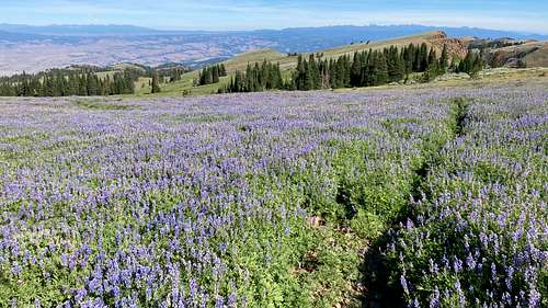
The trail comes out of the trees and into some beautiful upper mountain meadows right after this picture: 
Immediately after coming out of the trees the trail goes through a short area with other trails crisscrossing it - these are not on the map and did cause my to pause and make sure I got on the right trail. This isn’t a big deal, just be aware of it and pay attention. After passing this area you are steadily but easily climbing up the mountain with amazing views to the south, west and north.
Second Junction:
I came to a junction with a downed sign. I went to the right, but I think going left might bring you close to the peak as well based on what I can infer from the map.


In some areas after this junction the trail is less obvious than a usual hiking trail. There are not any cairns but it was easy to find my way. When I hiked, the lupin was in full bloom, which may have been the reason for some of the trail obstruction.
After a bit more climbing the first hint you see of a peak is up ahead with what I am guessing is an old utility pole at the top of it. This is not the summit or the old Council Mountain lookout which is one peak to north of Council Mountain. The trail brought me up on the west side of this and on to the Council Mountain Lookout.
After a short break at the old lookout (almost nothing is left but some concrete, scrap metal and broken glass) I continued on to the peak. The trail brought me down off the Council Lookout to the saddle between this and the peak.
There is still no complete trail to the peak from this direction (north). If you keep your eyes open you will be able to see some trail starts, but these do not continue to the peak. I missed these small turn offs and followed the main trail that would take me to the west of the peak. When I realized that if I kept going I would be going south of the peak, I turned east and hoofed it up the steep hillside for the last 300-400 feet to the summit.
**Please note that my trail up is shown in blue. My route down off the summit is shown in green. This route would be easier to hike up than what I did. 
