
-
 21673 Hits
-
 89.01% Score
-
 28 Votes
|
|
Mountain/Rock |
|---|---|
|
|
44.71060°N / 116.2963°W |
|
|
Adams |
|
|
Hiking, Scrambling |
|
|
Summer, Fall |
|
|
8126 ft / 2477 m |
|
|
 The Hike
Overview
Council Mountain is an attractive peak that anchors the northern end of the West Mountains in the Payette National Forest of central Idaho. It is the third highest peak in the range, but its taller neighbors are almost 20 miles to the south. As a result, Council Mountain offers up some expansive summit views, thanks to 2286 feet of prominence, which good for a #69 ranking on the Idaho prominence list. Surrounding mountain ranges visible from the summit include the Wallowas, Seven Devils, Lick Creek Range, and Owyhees.But the great views aren’t the only factor that makes Council Mountain one of the more desirable summit destinations in the area. Several of the peaks along the main crest of the range have roads leading to the top, but not this one. Council Mountain is actually nestled in the heart of a 16,000 acre inventoried roadless area that surrounds the peak. This allows for some scenic hiking and solitude on the approach to the peak.
 The Views The Views |
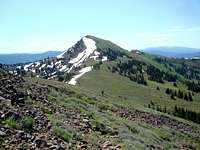
 The Summit The Summit |
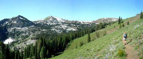 Great views from the trail. Great views from the trail. |
The area around Council Mountain is home to a variety of wildlife and offers up some pretty diverse terrain. To the north of the peak lies the aptly named Granite Basin, a cirque containing several beautiful subalpine meadows flanked by occasional granite outcroppings and slabs. The west side of the mountain offers up stands of big mountain sagebrush growing on slopes dotted with occasional fingers of basalt talus. The area provides a sampling of many different types of vegetation and rock, but an abundance of wildflowers is probably the main highlight. Very few spots in Idaho provide such a big variety of wildflowers condensed into such a small area.
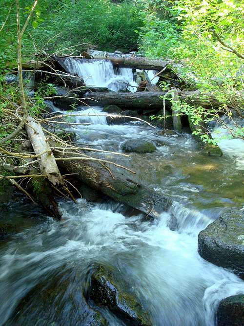 Granite Creek
Getting There
 Granite Basin
There are a number of primitive trails crisscrossing the area surrounding Council Mountain, and therefore many approach options for reaching the top. Based on the entries in the summit register, the peak is sometimes climbed from the west side out of the Council valley, but most of the hiking traffic seems to come from McCall-Donnelly in the east. The directions below will focus on the Granite Creek approach, which seems to be the most popular route.
The Drive – From Donnelly Idaho (on Highway 55, about 87 miles north of Boise, or 12 miles south of McCall), go left of Roseberry Road towards Tamarack Resort. In a little under 2 miles, turn right on West Mountain Road just after crossing the reservoir. Follow this for about 1.2 miles, then head left uphill into to forest on the road leading to No Business Saddle. Once at the saddle, continue on the road most traveled (FS-186) for about 2.5 miles, and then turn right onto FS-245. From there, drive uphill for a mile or so, watching for the short road to the trailhead on the left. The trailhead is near the spot where Granite Creek meets the Middle Fork of the Weiser River. (Google directions to trailhead.)
The Hike – The hike starts on an old logging road that is gated and not open to motorized traffic. After a mile or so, watch for a “trail” marker just after the road makes a switchback. The trail (FST-210) is pretty well constructed, and makes its way through the shady forest, crossing overgrown roads form time to time on its way to the high country. After about 3 miles, the trail gains the ridge above Granite Basin, and the views begin to open up. At just over 4 miles, the trail forks. One branch drops into Granite Basin, and the other stays on the ridge. Either option will get you to the summit, but the easier of the two is to stay with the ridge. Follow the trail up and over Pt 7923’, then to the summit via the northwest ridge of Council Mountain. The trail gets you to within a few hundred feet of the summit, with just a little bit of open cross-country travel to get you to the top. To make a nice loop, descend the north east ridge of Council Mountain, and then follow the trail through Granite Basin back to the previously mentioned trail junction. The hike totals about 12.5 miles round trip with 2800 feet of elevation gain.
Camping
[img:699931:alignright:medium:Granite Basin]There are many unimproved campsite possibilities on the approach roads to Council Mountain. Trailhead camping probably isn’t advisable due to space constraints. There are also a number of campsite options at various points along the trails leading to Council Mountains. Granite Basin would make an excellent camping destination, with great scenery and abundant water nearby.
Mountain Conditions
- Payette National Forest - NF Home.
- NOAA Pinpoint Forecast – Weather.
- Idaho Outdoors Forum – Message board monitored by many local climbers.
When To Climb
The prime hiking season for Council Mountain runs when the snow melts off the access roads in mid June, until the snow flies in late October or early November. Access is likely possible earlier in the year form the west side. Early summer is the best for wildflower viewing, with hunters likely being most of visitors in the fall.Red Tap
No permits, parking passes, or any other kind or red tape to worry about. Just tread lightly and respect the fragile nature of the local ecosystem.External Links
- Splattski Trip Report
- IdahoAlpineZone Trip Report
- Council Mountain on Lists of John
- Council Mountain on ACME Mapper
  |