
|
|
Mountain/Rock |
|---|---|
|
|
37.95490°N / 105.5751°W |
|
|
Saguache |
|
|
13270 ft / 4045 m |
|
|
Crestolita Overview
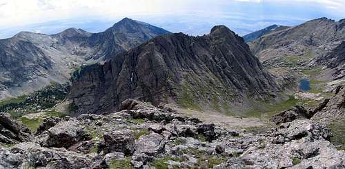
Crestolita
Surrounded by giants, beautiful Crestolita (UN 13,270) is an oft-ignored summit south of the famed Crestone Peaks. Many folks pass by the 423rd highest peak in Colorado on their way to 14er glory, but few will stop to notice it and even fewer will return to climb it. If you seek dazzling views from an obscure and alluring summit, add Crestolita to your list!
Despite being more than 1000' lower than nearby Crestone Peak, Crestolita is still quite dramatic, with steep faces and cliffs guarding it on all sides. Crestolita has two summits: the western is the taller summit, with the eastern only a handful of feet lower. A north-facing couloir between the two provides one of the few ways to climb the peak via a non-technical route. A fourth-class route ascends the peak's northeast ridge. With its dual summits and Crestone Conglomerate composition, its appearance as seen from Broken Hand Peak is that of a miniature set of Crestones. Gerry Roach coined the name Crestolita, which appropriately attaches a Spanish diminutive to the name Crestone.
Crestolita can be climbed as a day hike, but it is a long one, unless you can drive to the 4WD South Colony Lakes Trailhead. If arriving from the San Luis Valley, you may prefer a high camp in Cottonwood Creek or at Cottonwood Lake. Expect solitude during your climb of Crestolita, but because of the peak's proximity to the Crestone Peaks, you can count on others being in the surrounding areas.
Red Tape
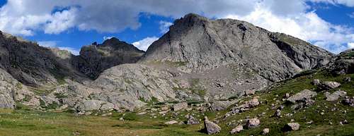
Broken Hand Peak & Crestolita
If using the Cottonwood Creek approach to Crestolita, please respect the landowners' wishes and abide by the following request which is taken from the Crestone Peak page:
From SP member Clyde Lovett: The land we cross to hike along Cottonwood Creek on the way up to Crestone Peak and Crestone Needle belongs to the Manitou Foundation (spirit@manitou.org). I have spoken face to face with these folks about we hikers crossing their land. They request that all hikers check in with them and sign a release form before crossing their land. I have indicated their email address above. Their postal address is PO Box 118; Crestone, CO 81131.
Crestolita is located within the Sangre de Cristo Wilderness. Typical wilderness restrictions apply. Contacting the managing agencies (see 'Mountain Conditions') is the surest way to get up-to-date information.
Leave No Trace suggests you observe these principles when traveling and camping in all public lands, especially wilderness:
1. Plan Ahead and Prepare
2. Travel and Camp on Durable Surfaces
3. Dispose of Waste Properly
4. Leave What You Find
5. Minimize Campfire Impacts
6. Respect Wildlife
7. Be Considerate of Other Visitors
When To Climb
The easiest time to climb Crestolita is July-October, but this varies year-to-year with the snowpack. In spring or winter conditions, this route would require an ice axe and crampons to negotiate what would be a snow-filled, north-facing couloir.Mountain Conditions
The US Forest Service is your best bet for determining current snow conditions and gathering other such information. The Saguache Ranger District (719-655-2547) of Rio Grande National Forest is responsible for the Sangres west of the range crest. The San Carlos Ranger District (719-269-8500) of San Isabel National Forest is responsible for the Sangres east of the range crest. Another good contact number for the east side is the Westcliffe Ranger Station (719-783-2079).For weather information, the National Weather Service is a good place to start:
Crestolita experimental point forecast
seano - Sep 24, 2016 5:02 pm - Hasn't voted
Access OKAs of 2016, it seems like they're allowing people to use the Cottonwood Creek trail: there is a Forest Service kiosk, and space for a half-dozen cars to park next to the road.