
-
 4721 Hits
-
 86.37% Score
-
 22 Votes
|
|
Route |
|---|---|
|
|
46.56546°N / 10.62727°E |
|
|
Mountaineering |
|
|
Summer |
|
|
Half a day |
|
|
Alpine F |
|
|
Overview
Croda di Cengles Normal route
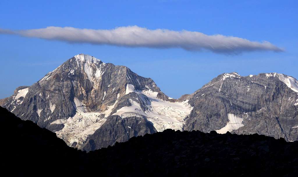
Croda di Cengles - Tschenglser Hochwand m. 3375 is a massive peak belonging to Ortler Alps Group. It's the northernmost last important summit located in Vertana-Angelo subgroup and occupies a particular position, being the point of convergence of three valleys: Cengles Valley to the North, Zai Valley to the South and Razoi Valley to the West. In reason of its situation the summit offers wide views over the major peaks of the group, as Ortles and Grand Zebrù just in front towards North and over Angelo and Vertana.
Croda di Cengles is frequently climbed; in addition of the two "vie ferrate", on the South side, the summit is also often climbed along the Normal route rising from Rifugio Serristor, an easy scramble following at first a steep gully, then the fine and panoramic South West ridge.
.


Getting There
The road approach is from Bolzano. The starting village to climb is Solda.
- from the Autobrennero exit Bolzano South and follow the road to Merano and Valle Venosta. Follow the Val Venosta road as far as the fork to Stelvio Pass. Here leave the main Val Venosta road and turn to left, taking the road to Stelvio Pass and then to Solda.
Walking approach
")
From Solda m. 1861 follow the path n. 5 rising along the Valle di Zai, reaching Prati di Zai (Zaywies) and Piano dei Laghetti (Seeboden), then the Serristori hut (2,30 hours from Solda). A faster approach is possible from Pulpito-Kanzel Rest m. 2350, the upper station of Pulpito-Kanzel chairlift starting from Solda, along the path n. 12a, joining the upper section of the path n. 5 (1 hour and half).
Route Description
Route report
Difficulty: the route is essentialy a walk in its first section, then an easy scramble when climbed in summer condition. May be graded Alpine F in last spring or early summer, when it becomes a bit more difficult, requiring the use of crampons and axe
Difference in level: 654 m. from Rifugio Serristori m. 2721
Exposure: South-West
Time required: 2,30 hours for the ascent, about 2 hours for the descent

From Serristori - Dusseldorfer Hutte m. 2721 take the path n. 5 to Passo di Zai, crossing the wonderful basin dominated by the majestic Cima Vertana, Angelo Grande, Croda del Forno and Angelo Piccolo and reaching a fork near a small lake m. 2886. Leave the main path to Passo di Zai and turn to left (yellow marks), rising on a steep scree and reaching the base of the rocks (signpost).


Follow the signpost "Normalweg" (red marks), heading to the left and entering a steep gully of debris (snow in early season). Climb the gully, getting to a saddle at the bottom of the SW ridge.

 Normal route")
Turn to right, climbing the easy and large ridge - some steps are equipped by iron chains - getting to the summit cross. Summit book. The view is wonderful!
Descent: reversing the route


Essential Gear
High mountain gear. In presence of snow and ice, possible in early season, crampons and an axe are reccomended.
Red Tape

No fees no permits required. Croda di Cengles is situated inside Parco Nazionale dello Stelvio, one of the hystorical national parks in Italy, belonging to the provinces of Trento, Bolzano and Sondrio. Free camping is not allowed and fires are forbidden. The whole fauna and flora are protected.

Hut

- Rifugio Serristori 2721 m.
Situation: foot of Angelo Grande and Cima Vertana, near largest one amongst the Zay Lakes
Owner: Autonomous Province of Bolzano - Alto Adige
Guardian: the refuge is managed by more than 4 generations by the family Reinstadler
Phone:+39 333 2859740 Mob
E-Mail: info@duesseldorferhuette.com
The hut was built in 1892 by the Düsseldorf section of the DAV. After the First World War the refuge passed to the CAI and until recently was owned by the Mailand section. It has been administered since 2010 by the Autonomous Province of Bolzano - Alto Adige. The refuge is managed by more than 4 generations by the family Reinstadler.

Approach to Rifugio Serristori - From Solda m. 1861 follow the path n. 5 rising along the Valle di Zai, reaching Prati di Zai (Zaywies) and Piano dei Laghetti (Seeboden), then the hut (2,30 hours from Solda). A faster approach is possible from Kanzel Rest m. 2350, the upper station of Pulpito-Kanzel chairlift starting from Solda, along the path n. 12a, joining the upper section of the path n. 5 (1 hour and half).
Season
Best months are June, July, August and September.
Guidebooks and maps


"Ortles-Cevedale" by Gino Buscaini - CAI TCI
“Prestigiosi Tremila del Sud Tirolo” by Hanspaul Menara – Athesia ed
“Alto Adige Occidentale” Guida alpinistica escursionistica by Achille Gadler – Panorama ed.
Meteo
METEO PROVINCIA BOLZANO ALTO-ADIGE