
|
|
Mountain/Rock |
|---|---|
|
|
40.43220°N / 105.4244°W |
|
|
Larimer |
|
|
Hiking |
|
|
Spring, Summer, Fall, Winter |
|
|
9250 ft / 2819 m |
|
|
Overview
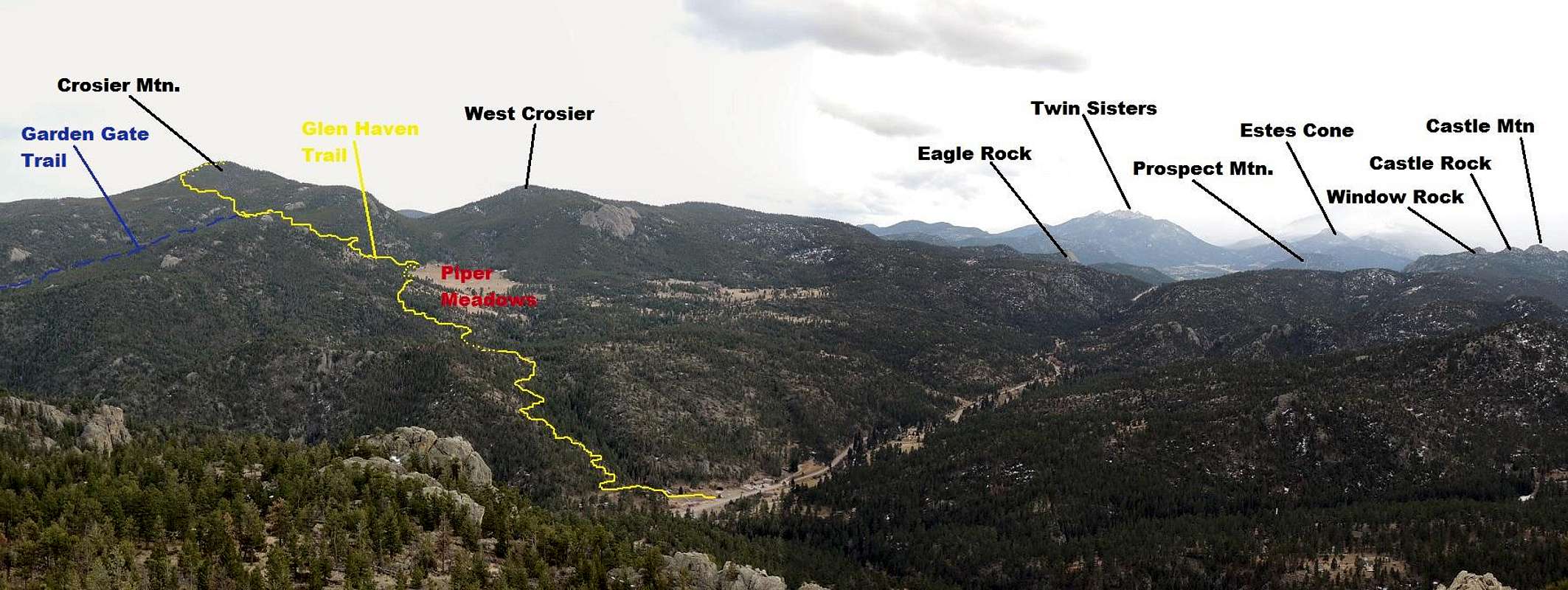
 Crosier Mountain is a somewhat hidden highpoint in a multitude of other Front Range peaks as the foothills transition into the mountains proper, specifically Rocky Mountain National Park and the Mummy Range. This mountain has year round access via three separate trails: Garden Gate, Rainbow Trail/Gravel Pit and Glen Haven. All are conveniently located within 8 miles of one another along CR43 between the towns of Drake and Glen Haven. Crosier is located in the Glen Haven quadrangle.
The Northern Colorado Mountains and the Roosevelt National Forest are very different from other Colorado wilderness areas. Most notable is the dryness/lack of water and flora. Crosier Mountain is a dry mountain with little to no water sources. So remember to bring plenty of fluids. And even then, I'd be leary of what you do find (even filtering) due to the overwhelming large presence of wildlife in the area. It can get intolerably hot in the middle of summer.
Despite the dryness and heat, all three trails are surprisingly delightful to hike, mountain bike or ride pack animals on (dogs are also allowed!). All three trails are of a moderate difficulty with Garden Gate being a borderline strenous but this more due to its length. On the trail, you'll encounter elk, whitetail, rabbit and the occasional porcupine or skunk. The usual barrage of squirrels and chipmunks as it winds through a landscape of Pine, Juniper, Bitterbrush, Yucca (Spanish bayonet) and Prickly Pear cactus can also be expected.
This is prime mountain lion habitat and black bear is frequently seen in the environs come spring into early summer as they forage and again in fall as they begin to put on weight. I have personally seen bear on two separate occasions in the hills just across the valley. Making loud noises will definitely 'announce' your presence to minimize any 'surprises'. Also, keeping dogs leashed in cat and bear country...I think goes without say. I've heard of Newfoundlands being attacked and killed by mountain lion, despite their size. So be aware while hiking or train-running.
Over the previous 10 years, there have been small prescribed burns and the Bobcat fire in 2000 (human caused) which burned thousands of acres of National Forest. The forest, however, has made an amazing comeback since.
The summit of Crosier Mountain will reward you with panoramics of Twin Sisters Peaks and Longs Peak to the south, Estes Park and Rocky Mountain National park to the southwest and west, Signal Mountain to the northwest and the Front Range to the east.
For additional information, please contact the following address or e-mail:
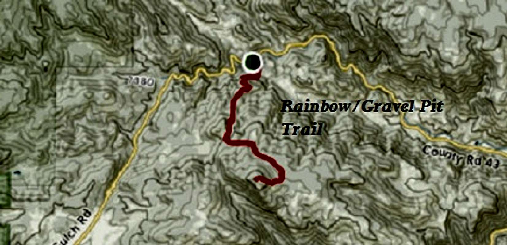
Correction: The blue line is actually the 'GRAVEL PIT' trail.
U.S. Forest Service Center
2150 Center Avenue Bldg. E
Fort Collins, Co. 80526
#970.295.6600
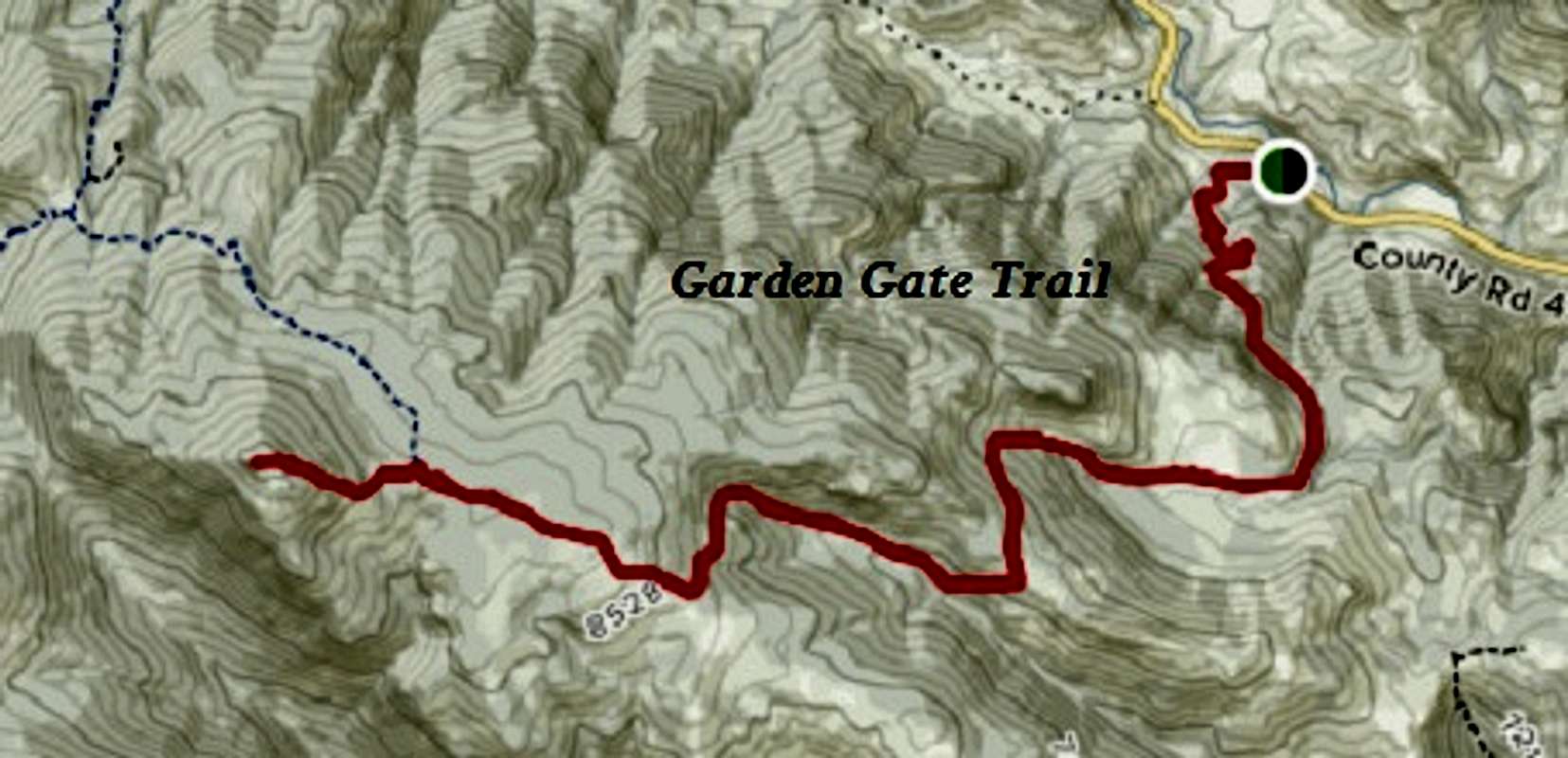
Garden Gate Trailhead #931
This trailhead is roughly 2.2 miles from the turnoff in Drake leaving Hwy.34 (Big Thompson Canyon). There is a small parking area on the south side (left) of the road. You'll need to open and close the gate to access the trail. From here, it is about 10.2 miles (RT) with a starting elevation of 6419ft. and ending at 8,742ft. The average grade of the trail is 11% with a max grade of about 41%.
Utilizing this trailhead, one can make for a fairly decent loop run by connecting one of the other two trails (trailheads) thereby, taking the road back to the Garde Gate Trailhead. The summit spur (trail #931.1) is only about .5 miles for a small addition.
The intersection with the Rainbow/Gravel Pit Trail comes after 5.8 miles and descending all the way to Glen Haven using the Glen Haven Trail comes in at about 7.8 miles. Then of course, the road-run back down to the Garden gate Trail-head.
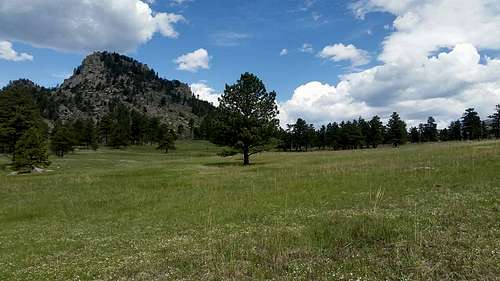
This particular trail enjoys quite a bit of solitude and quiet as it doesn't see much foot traffic. Yet oddly, the trail remains in pretty good shape. Roughly 3.2 miles up the trail, the terrain opens up into a nice grassy meadow with a seasonal but small stream that runs through the center. There are plenty of opportunities here to pitch a tent and camp and the odds of seeing deer or fox is high.
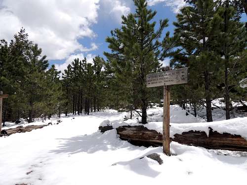
The trail starts gently enough and switchbacks quickly to attain the south ridge which is in plain sight for most of the way. Once over, the trail will drop and rise sporadically and deposit you into said meadow with easy hiking and some awesome camping spots. Once past the meadow, the trail climbs again up a shallow ravine until it levels off in a dense Pine forest and meets up the Rainbow/Gravel Pit Trail. It is then only another .5 mile on the summit spur trail (#931.1) to the top.
Rainbow Trail/Gravel Pit Trailhead #981
This trailhead is also located on the south side of the road (left) and is about 5.5 miles from Drake. It is very distinct with a large parking area that will accomodate many vehicles. There is some private property located near the trailhead for the first 3/4 mile, so please adhere to the trail.
It is roughly 8.5 miles (RT) with a starting elevation of 6,600ft.
From the trailhead to the main Crosier Trail junction, it is about 1.9 miles and reaches the trail at an elevation of 8,252'. The average grade on this trail is 13% with a maximum of 23%. Camping is scarce and hard to find along this trail due to the ravine and thick Lodgepole Pine forest.
The trail starts off by heading straight up a ravine/gully and gains altitude quickly. It levels out sporadically as it switchbacks up the ridge. The private homes located on the other side of CR43 are in view for most of the time until you breach the ridge.
The trail continues to meander through forest and follows a creek for a good portion of the way until it meets up with the Glen Haven Trail.
From here, it is still about a half mile east (left) to the intersection with the Garden Gate Trail.
There is a small old cabin at this junction located just a hairs-width off the trail. This particular trail segment is good to run.
Glen Haven Trailhead #931-2 (CLOSED)
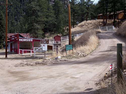
This trailhead is located in the town of Glen Haven and is now CLOSED. However, I'm leaving it here for informational purposes.
Parking here is tight and constricted at best. Use the small post office located just up the road. However, there is also a small dirt clearing just opposite the access road one can park. There is only enough room to park say, three vehicles. There is a dirt road/driveway leading southeast just past the red horse stable. There is also a brown sign reading, "Crosier Mountain TH". The trail starts about 150-200ft up this dirt road and is marked.
From here, it is about 8 miles (RT) with a starting elevation of 7,320. There are places to camp along this particular trail as well but are harder to find.
There is also the option to purchase food and drink at the General Store in town in case you've forgotten yours.
Estes Park is only a few more miles up Devils Gulch where it turns into MacGregor Avenue .
The trail attains altitude at a modest pace. Probably the easiest trail of the three. It partly follows a creek, meanders through the forest, hits 'bald' spots and navigates around Piper meadows (which I believe is privately owned by the H-Bar-G ranch). At the top of Piper Meadows, the trail forks to the left, which continues to Crosier or right which access the ranch. From this vantage point, it is only about 15 minutes to the trail junction with Rainbow Trail.
Getting There
As said, all three trailheads are located directly on CR43 between Drake and Glen Haven. Travel 7-8 miles past the 'Dam Store' on U.S. Highway 34 up Big Thompson Canyon west of Loveland to the small town of Drake. Turn right onto County Road 43 (Glen Haven Road). Without making directions too complicated since there are three access points:
| Garden Gate Trailhead | Rainbow/Gravel Pit Trailhead | Glen Haven Trailhead |
| 11.0 miles from Estes Park | 7.4 miles from Estes Park | 6.3 miles from Estes Park |
| 15.2 miles from Loveland | 18.2 miles from Loveland | 19.8 miles from Loveland |
Camping
 The best spots for camping on Crosier Mountain are to be found in the meadows located on the Garden Gate trail segment. Finding flat, grassy ground here is almost guaranteed. But remember, this is a dry trail; there are no water sources here. Plan on packing in all your water needs.
Camping is discouraged at the trailhead (car camping though noisy, should be fine) and the usual National Forest guidelines of staying at least 100 feet away from water sources while camping are expected and encouraged. There are some places to camp on the now closed Glen Haven Trail. Also, at the top of the Rainbow/Gravel Pit trail near Point 8,434 where it connects to the main trail, there is some flat ground to throw a tent. This area is also sparsely forested, so there is a modicum of protection from the elements. And remember, Leave No Trace! Campfires are permitted. Just be cognizant of restrictions and dangers.
If the parking area(s) are full, there is also camping at the Dunraven Trailhead just a smidgen up the road. From the Gravel Pit trailhead, continue up the road towards Estes Park for .2 miles to county road #51B. This will be on the right side. Cross over the bridge and drive the dirt road for 2.2 miles to the trailhead. This is LARGE trailhead with AMPLE room to park and camp. There is private property on the way there on both sides of the road.
Maps
|
|