Welcome to SP!  -   
 
 New features are here! - Read More... 
Areas & Ranges·Mountains & Rocks·Routes·Images·Articles·Trip Reports·Gear·Other·People·Plans & Partners·What's New·Forum

Crowfeet Mountain

 
[ Sizes: Orig | Large | Med | Small | Thumb ]
Crowfeet Mountain
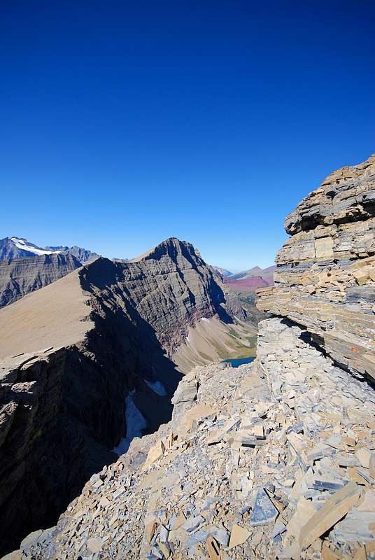
The ridge connecting Crowfeet Mountain (center) and Mount Henkel (right foreground) is clearly visible. According to J. Gordon Edwards, it's about a mile between the two peaks, with approximately 1,000 feet of elevation loss and gain. The ridge affords wonderful views of the Ptarmigan Lake / Iceberg Lake valley to the west; to the east, a 2,000 foot vertical cliff drops down to Kennedy Lake.

Had the pleasure of watching three different groups of mountain goats traverse Crowfeet's steep north face. It was truly incredible!

15 September 2008


Comments

No comments posted yet.


Sign in to post!

Don't have an account? Register now.


Rate This Image
Current Score: 88.81

Log In To Vote
 Crowfeet-Henkel-Apikuni Traverse (Route)


You are at
the First
Image

Viewing
#1 of 24
GALLERY
bull moose near Ptarmigan Lake
NEXT »

 distressbark's Image Gallery

Skyline Experience
« PREV

Viewing
#13 of 377
GALLERY
Wynn Mountain (8,404 ft.)
NEXT »


 Glacier National Park, MT (Area/Range)


 Crowfeet Mountain (Mountain/Rock)


 Mount Henkel (Mountain/Rock)


 to dance beneath the diamond sky (Album)


 Extraneous Photo Dump—GNP (Album)


Image Data

distressbarkSubmitted by distressbark
on Dec 17, 2008 12:48 pm

Image ID: 472795
Hits: 1685 

Lat/Lon: 48.82020°N / 113.68621°W

Image Type(s): Hiking, Scenery


"And what do the birds say? All there is to say about a massacre, things like, "Poo-tee-weet?""   --Kurt Vonnegut   

© 2006-2012 SummitPost.org. All Rights Reserved.