
-
 15817 Hits
-
 90.81% Score
-
 33 Votes
|
|
Route |
|---|---|
|
|
48.79963°N / 113.67903°W |
|
|
Hiking, Scrambling |
|
|
Summer, Fall |
|
|
Most of a day |
|
|
Strenuous Hike, Primarily Glacier NP Class II and III climbing |
|
|
Overview
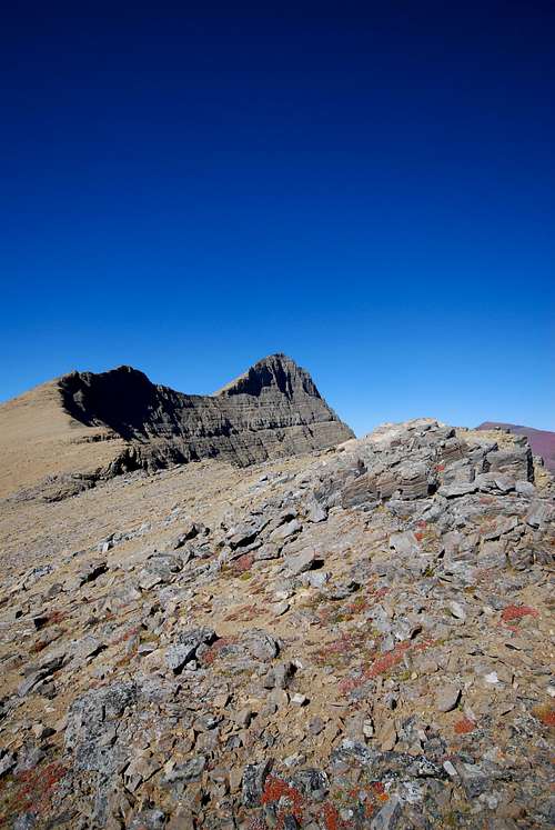
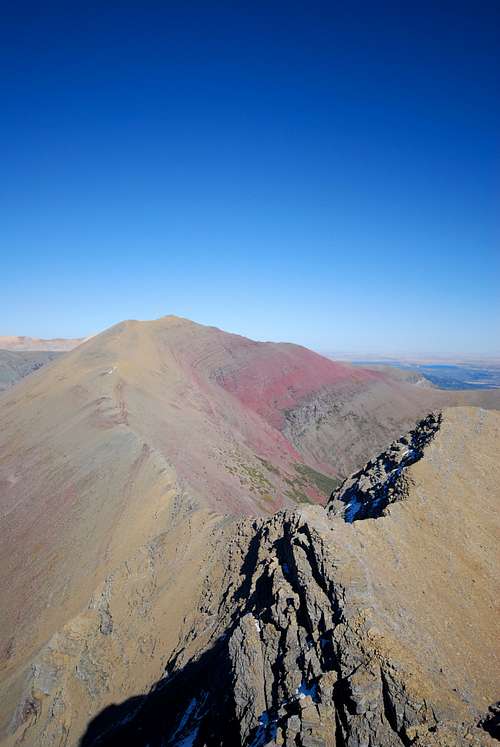
The ridge connecting Crowfeet Mountain (center) loses about 1,000 feet in elevation and spans approximately one mile before reaching the summit of Mount Henkel
For many, spending the bulk of the day scrambling to the top of one of Glacier National Park's lofty summits is a worthwhile endeavor. Glacier's sedimentary rock presents some unique challenges to mountaineers. The lower slopes of many mountains are blanketed by seemingly never ending fields of loose rock, which can make for long, tiring approaches. As one clumsily stumbles over clunky blocks of talus and sinks ankle deep in scree that resembles quicksand more than rock, frustration and exhaustion may soon set in. Sure, the scree slog is often deemed worthwhile once the summit is attained; it's a time to take photographs, to turn over obscure rocks, to enjoy lunch with friends... and soon the struggles of the ascent are forgotten as you gaze out upon the bounding anomalies that stretch out as far as the eye (or weather) permits.
But herein lies one of the many beauties of Glacier National Park. There are numerous options for multi-summit days, where those willing to endure a tiring climb up the loose lower slopes of one mountain are rewarded with long, scenic ridge walks atop that often lead to the top of several different mountains. The ridges tend to be solid, incredibly easy to navigate, and quite enjoyable to simply to stroll atop. And did I mention the views?!
This page details a long, incredibly scenic route located in the Many Glacier region of Glacier National Park. It includes the summits of three peaks; Crowfeet Mountain (8,914 ft.), Mount Henkel (8,770 ft.), and Apikuni Mountain (9,068 ft.), and along with some enjoyable climbing affords spectacular vistas from the extended ridge connecting the three mountains. The route can be completed in one long day; I estimate that a loop starting and ending at the Many Glacier Hotel is somewhere in the vicinity of 14.5 miles, of which over half is by road or maintained trail.
Getting There
Glacier National Park is located in northwest Montana, sharing its northern border with Waterton Lakes National Park in Alberta, Canada. The park features an impressive, ragged stretch of the Rocky Mountains, with varying slopes that will challenge hikers, scramblers, and experienced technical climbers alike. One thing that has so enthralled me about Glacier and its crumbly peaks is that many of them, with the right amount of fortitude and correct route information, can be ascended without any technical rock climbing. Rock walls that look impossible to climb from afar require a second, closer look; I've had the pleasure of venturing up/down a few of these slopes, and a lot of them are much more welcoming than they first appear.The Many Glacier region of Glacier affords some of the best hiking and climbing you'll find anywhere. The rugged Lewis Range slashes through the area, with evidence of long-gone seas of glaciers left behind in the form of sweeping U-shaped valleys and craggy mountain peaks. Many Glacier is on the east side of the Continental Divide, about 12 miles west of US-89 and the small, unincorporated town of Babb, MT. If coming from the west, one can enter the park at West Glacier, MT and drive the famed Going-to-the-Sun Road across the Divide, descending to US-89 at St. Mary on the east side of the park. From here, it's another 20 miles to Many Glacier. For information on entrance fees and camping, everything is on the National Park Service website: http://www.nps.gov/glac/
I rely very heavily on J. Gordon Edwards' essential A Climber's Guide to Glacier National Park whenever climbing in the park. It's a fantastic, enjoyable guide, and I highly recommend investing in one during your next foray into Glacier's wilderness. It helps put some of these seemingly impassable mountains in perspective, and has provided me with ideas for countless future Glacier endeavors to come!
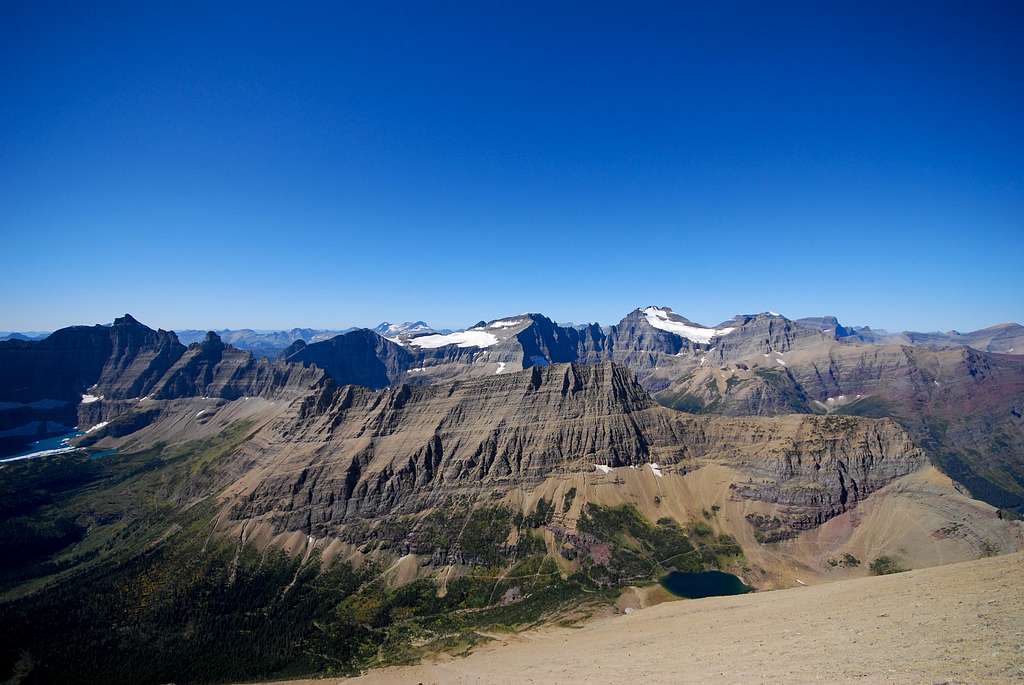
the Many Glacier Valley from Altyn Peak
Route Description
As an employee at the Many Glacier Hotel, I started the hike from the dorms east of Swiftcurrent Lake and hiked 1 mile west to the Swiftcurrent parking lot. However, if you're in the valley and have access to an automobile, you might as well drive to Swiftcurrent parking lot and start from there. It saves a mile of walking along a combination of a busy nature trail and the shoulder of a busy road. However, when ending at the parking area near Apikuni Falls, you'll be two miles east of your starting destination. Bust out the thumb!Crowfeet Mountain
So, starting from the Swiftcurrent campground, find one of two trailheads leading to Iceberg Lake/Ptarmigan Tunnel. Both are in close proximity to the Swiftcurrent Camp Store, and there's good signage pointing you to either starting point. The first 2.7 miles of this popular trail takes the hiker along the south side of Mount Henkel, steadily gaining 1,000 feet through a mixture of grassy, wildflower-laden slopes and dense forest before coming to Ptarmigan Falls. It's a particularly nice spot, and a very popular destination for visitors who are looking to go on a short hike while in the park. Cross Ptarmigan Creek, and the trail will soon come to a junction. Take the trail to right, towards Ptarmigan Lake/Ptarmigan Tunnel. From here, the trail climbs rather steeply over 2 miles through tall stands of pine to Ptarmigan Lake. As the trail approaches the foot of Ptarmigan Lake, many well-worn paths lead downhill to the right towards Ptarmigan Creek. Take whichever one your heart desires, and cross Ptarmigan Creek. Head up to the south shore of Ptarmigan Lake for a break; it is a fantastic spot! To the north are three long switchbacks leading up to Ptarmigan Tunnel, the the west is the steep, jagged east face of the Pinnacle Wall, and to the south are the large masses of Mount Grinnell and Mount Wilbur. In my several visits to this serene tarn, I've spotted mountain goats, bighorn sheep, two wolverines, a marmot fight, and a solitary bull moose. It truly is a magical little place!
Looking to the east, observe the scree-ridden western slope of Crowfeet Mountain. I found a large drainage leading up the first part of the slope, and started my ascent there. Coming out of the drainage, you'll encounter a bunch of class III cliffs that can be easily and safely navigated. Soon after, brace yourself for a true trudge of scree climb! The scree here is like quicksand, and it really takes a lot of effort to make any kind of quick progress across the rocks. As you ascend the scree, aim east for the large, rectangular prominence that eventually is visible ahead; this is the summit block of Crowfeet Mountain. As you approach it, look for a large crack in the middle of the summit prominence, and squeeze your way inside. From there, an easy way to climb up will become noticeable. Once on top, the summit cairn is just a few feet to the north. The sheer, loose east face of Crowfeet drops some 2,000 feet down to picturesque Kennedy Lake, with Kennedy Creek winding far off to the east into Poia Lake. The stark west face of Chief Mountain pokes out behind the gorgeous red slopes of Seward Mountain. To the west, behind the Pinnacle Wall, is the massive complex of ice and rock that includes Ahern Glacier, Ipasha Peak, Old Sun Glacier on the northeast face of Mount Merritt, and Natoas Peak. Iceberg Lake and Ptarmigan Lake are but two beautiful small drops of water in the valley below.

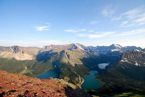
View west from Crowfeet Mountain. Kennedy Creek meanders several miles through dense foliage to Poia Lake.

No trails lead to rarely visited Kennedy Lake. It's ungulate paradise down there!
Head towards the south from the summit, taking care to find an easy way down the loose cliffs. After a couple of short class III descents, you'll come upon the long ridge connecting Crowfeet to Mount Henkel to the southeast. It's about one mile to the summit of Henkel, with the ridge dipping approximately 1,000 feet along the way. Take time to admire the steep east face of Crowfeet. I had the pleasure of watching three separate small groups of mountain goats traverse this slope via their impossibly perched trails, and marveled at how they survive unscathed as they kicked loose rock on a violent tumble down the side of the mountain. As you approach Henkel, a few well-worn scree trails lead the way towards the summit. After a tiring little scramble, the summit cairn is finally reached. The view of Crowfeet's east face gives you a new appreciation for the mountain. Chief Mountain and Gable Mountain perch mightily to the north. The impressive east face of Mount Wilbur is visible to the southwest, with marvelous Heaven's Peak looming behind the Continental Divide. Views to the southeast are also particularly stunning; the Lewis Range reaches far off to the distance, with Allen Mountain and Mount Siyeh towering far behind the Many Glacier Hotel. Divide Mountain is visible over the broad, flat summit rigde of East Flattop Mountain, and the snowy mass of Blackfoot Mountain stands impressively to the south. To the northeast is the long ridge leading up to the red rounded summit of Apikuni Mountain.
The ridge between Crowfeet and Henkel (left).
Mount Henkel to Apikuni Mountain
From Mount Henkel, it is easy to traverse all the way to the rounded tan summit of Apikuni Mountain. Follow the ridge from Apikuni Mountain to the point where it intersects Mount Henkel's summit ridge in the foreground (the small point that is directly beneath the green patch of foliage in the background); from here, you can safely descend on the right side of the ridge, climbing down through mostly class III cliffs until the broad, flat ridge to Apikuni is reached. From here it's an easy stroll to Apikuni's summit.
From the summit of Henkel, head towards the east; you'll eventually encounter some nasty cliffs. Make your way off the summit ridge to the south, climbing downward until one of several wide ledges can traversed back to the east. You'll soon regain the summit ridge at the low point between the true summit of Mount Henkel and a false eastern summit that borders the great screen basin to the south. At this point, the great ridge that heads toward Apikuni Mountain will be clearly visible; make your way down along the right side of the ridge and onto a wide scree shelf. Huge cliffs will block futher progress, but you'll find a class IV couloir that can be easily descended. There are great handholds in the couloir, and after downclimbing 20 feet or so, it's smooth sailing the rest of the way. You can follow scattered scattered trails on either side of the ridge, and before long the terrain will flatten out significantly and you'll be walking on a solid, broad portion of the ridge that connects to Apikuni. Just like the Crowfeet to Henkel traverse, the traverse to Apikuni loses about 1,000 feet and covers a mile. To the southeast is Natahki Lake, a beautiful tarn situated amongst a forest beneath the slopes of Altyn Peak. The views from the summit of Apikuni are not much different than those from Mount Henkel; the real treat is to look back to the west, where the full route comes into splendid view. On a clear day, you can see far past Duck Lake to the east, and the rounded humps of the Sweetgrass Hills may even be visible.
Descent from Apikuni Mountain
From Apikuni, J. Gordon Edwards recommends to head east down the summit ridge in an attempt to avoid the scree and cliff-filled southern slopes of the mountain. There are a bunch of hiking/game trails along the way, and they all appeared to swing well out to the east to where the descent to the valley below will be much gentler. I, however, decided to head south/southeast, and ran down some scree fields while stopping to climb down the occasional steep, rocky chute. I never encountered anything worse than class III, and I felt like the stretches where I found extended batches of scree helped me descend rather quickly. After leaving the scree slopes, I bushwhacked through some shrubs while angling to the southeast; in hindsight, I would recommend following any one of the drainages down to the valley. In September, they were all dried up and looked to provide a clear path down to some flat ground. Eventually you'll end up at the bottom, and from there a trail bisects the quaint little valley that sits beneath the summit Altyn Peak. Follow the trail down past Apikuni Falls; from the falls its but a mile back to the road. From the road hitch a ride or walk one mile along the side of the road back to the Many Glacier Hotel (2 miles to Swiftcurrent).
NOTE: This traverse could most certainly be enjoyed in the opposite direction, starting from Apikuni and ending with a descent down the western scree slopes of Crowfeet Mountain. However, J. Gordon Edwards probably sums it up best: although the climb to the summit of Crowfeet ain't the greatest, the ascent up the loose rock on Apikuni's south/southeastern slope is worse. Starting from the Iceberg Lake/Ptarmigan Tunnel Trailhead, over 2,000 feet of elevation is gained over 5+ miles on a well-maintained trail before any off-trail hiking is required. Ascending Apikuni first requires a steep, 700 foot climb on trail to Apikuni Falls; from there, a climber's trail leads through the meadows above the falls, gradually gaining a short amount of elevation. Then it's a scree slosh up the slopes of Apikuni. So, if you're a glutton for punishment, be my guest.

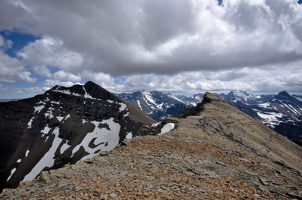
Looking west back down the ridge connecting Mount Henkel (left) to Apikuni Mountain (foreground). The sheer wall in the middle right portion of the photograph is the 2,000 foot east face of Crowfeet Mountain, the first summit of the day. The wondrous silhouette of mountains in the background contains the peaks that this inspiring route has allowed you to admire all day long.
Essential Gear
One more plug for J. Gordon Edwards' A Climber's Guide to Glacier National Park. Great route descriptions of peaks all throughout the park. A topographic map wouldn't hurt, nor would a compass. It would be very difficult to get lost on this route, but the map and compass come in handy for identifying peaks and lakes from the top of these three wonderful summits!The Many Glacier Valley is home to many dangerous animals, including mountain lions, black bears, and grizzly bears. Bring bear spray, a buddy to hike with, a loud voice, and you should be fine.
Bring water, or plan to treat water along the way. After Ptarmigan Lake, you'll likely be without water for quite some time. Seeing as how this is the most strenuous section of the route, I'd recommend filling up a bottle or two at Ptarmigan Lake. After descending Apikuni, you can fill up again at Apikuni Creek to help quench your thirst over the last few easy miles.
When to Climb
The southern slopes of Crowfeet, Henkel, and Apikuni can be free of snow as soon as July. July - September seems like the ideal time to attempt this hike. However, I think you could summit Henkel from Swiftcurrent Motor Inn and traverse to Crowfeet without too much trouble from a little bit of snow. Hence, there are likely some interesting late spring/early summer hiking/climbing opportunities along these three mountains.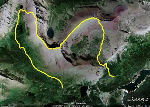
Crowfeet-Henkel-Apikuni Traverse Route
Where to Stay
Camping is available at the Many Glacier Campground. The entire campground can fill well before noon in the short, busy summer season (June through Labor Day), and there are no reservations; plan on getting there early. Other options include a stay at the historic Many Glacier Hotel or the more modest Swiftcurrent Motor Inn. Refer to the National Park Service's Glacier Webpage for additional information.Other Circuit Routes
Gordon Edwards details several routes that involve high ridge traverses to multiple peaks. It truly is special to spend a significant portion of the day above the tree line, walking atop open ridges with spectacular views in every direction. I recommend giving any of these a try; you will not be disappointed.- start out early on the trail to Cracker Lake. Leave the trail after 3.5 miles and scramble to the top of Wynn Mountain. A glorious, 5.5 mile long ridge leads all the way up and over Peak 9190 and Cracker Peak before culminating atop massive Mount Siyeh. Refer to my route page for details.
- from Rising Sun Motor Inn, take the trail towards Otokomi Lake, eventually venturing off-trail to the summit of Otokomi Mountain. A wide ridge leads to the summit of East Flattop Mountain; from the summit, a short detour to the east leads to Singleshot Mountain. By returning to East Flattop, one can then head north and enjoy the three mile long ridge walk on East Flattop toward Napi Point.
- check out jimegan's trip report for Red Eagle/Mahtotopah/Little Chief, which involves a glorious ridge walk high above the deep blue waters of St. Mary Lake.
- Mad Wolf Circuit: starting from Cut Bank Campground, it's possible to bushwhack/climb to the summit of Mad Wolf Mountain, where a ridge connects to Eagle Plume Mountain and eventually to Bad Marriage Mountain.
- from the Lunch Creek pullout a few miles east of Logan Pass, the hardy mountaineer can easily summit Piegan Mountain, Pollock Mountain, and Bishop's Cap. You can return to your car near Lunch Creek, head downhill to the Highline Trail from Bishop's Cap, or retrace your steps to the saddle between Pollock and Piegan for a descent to Piegan Pass into Many Glacier. Great route photos and information in Blake Passmore's Climb Glacier National Park; for more info, visit his website: http://www.climbglacier.com/.
- from Two Medicine Lake, hike steeply uphill over three miles on the Scenic Point Trail. From the top, one can enjoy a prolonged ridge walk to the south that includes summits of Medicine Peak and Mount Henry. From Henry, many hikers head towards Appistoki Peak, but options abound, as another long, spectacular ridge leads to Mount Ellsworth and Never Laughs Mountain. Refer to the Climber's Guide or two Blake Passmore's Climb Glacier National Park Vol. 2 (http://www.climbglacier.com/)for detailed information regarding the numerous routes among these peaks.
FlatheadNative - Mar 24, 2010 11:00 am - Voted 10/10
More LoopsYou could also add Never Laughs and The Scenic Point Traverse to your section on loops on the bottom of this page. Both of these are great routes.
distressbark - Apr 7, 2010 1:13 pm - Hasn't voted
Re: More Loopsupdated on this page as well as my Skyline Experience page. am looking forward to attempting the ridge walk from Scenic Point to Appistoki Peak (weather permitting) come early June!
FlatheadNative - Apr 7, 2010 5:09 pm - Voted 10/10
Re: More LoopsYou will really enjoy it. Let me know when u are going to do it and I may join you.
distressbark - Apr 8, 2010 8:40 am - Hasn't voted
Re: More Loopswill do. unfortunately, after May 28th, my internet access will be spotty at best. not certain what days off will look like for the summer, etc. but, we're hoping for sometime in the first week of June.
FlatheadNative - Apr 8, 2010 10:30 am - Voted 10/10
Re: More Loopscool...should be a good time of year for that ridgewalk. Not a lot of snow here this year. I will PM you my cell number as well as my days off that first few days of June.
FlatheadNative - Aug 13, 2012 9:05 pm - Voted 10/10
Heyif you want you can throw a link to my webpage for Climb Glacier National Park for Bishops Cap, Piegan, Pollock traverse as well as the Scenic Point Traverse which is found in Volume 2
distressbark - Aug 15, 2012 10:18 am - Hasn't voted
Will do!Thanks.