
-
 4944 Hits
-
 71.06% Score
-
 1 Votes
|
|
Route |
|---|---|
|
|
37.07819°N / 3.48157°W |
|
|
Hiking, Scrambling |
|
|
Spring, Summer, Fall |
|
|
Half a day |
|
|
Hike and Scramble |
|
|
Overview
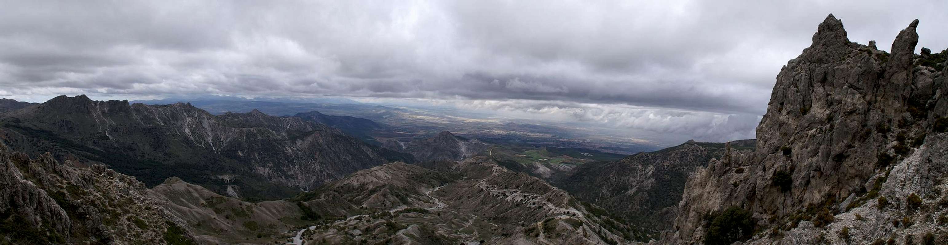
 Summit view across Cuerda del Trevenque Summit view across Cuerda del Trevenque |
There are several routes to Cerro del Trevenque, most of which make use of long hikes along dirt roads to get towards the saddles from which the final ascent of the mountain begins. The Cuerda del Trevenque route is no exception though it's highly recommended to leave the route for a traverse of the sand dunes as soon as the highly eroded western slopes of the Cuerda are left behind. Switching back to the road is possible in several locations in case it turns out that the ridge is to difficult to hike.
The Cuerda del Trevenque is a sand dune like moraine, very fragile though the sand is baked together. A multitude of Gendarmes rise out of these dunes, often bizarre to look at and always easy to negotiate around. Rock quality is horrible, which also applies to Trevenque itself. The final assault of the mountain along its north-western ridge is steep and - thanks to the sand - rather difficult and dangerous. The real danger, however awaits you when descending the mountain. The sand will easily give way and there is no way to protect yourself.
Getting There
 Cerro Gordo (1891m), Cerro del Cocon (1868m) as seen from the route
The climb starts at the small parking lot at Mirador de los Alayos, which can be reached via a mountain road from La Zubia. See the main page for the access information.
Route Description
  |
- Start altitude: 1370m
- Summit altitude: 2087m
- Prevailing exposure: W
- Type: Hike and steep sand scramble
- Protection: None
Leave the parking lot at the mirador towards the east and immediately turn onto a barely visible path (sign prohibiting mountain bikes). The path soon joins a sandy mountain road, which you can follow right to Collado de MArtin for the southern ascent of Trevenque. After a couple of hundred metres another road turns off to the left, leading directly to the west ridge of Trevenque. Follow the road in its windings through the sand dunes. You'll see that every gully is numbered, sign for the erosion studies which take place in this location. Stay on the road until in a long bend it turns northward,, heading directly for the ridgeline of the Cuerda del Trevenque.
You might follow the road to the Trevenque west ridge, but it is far more interesting to follow the ridgeline. The road runs to the south of the ridge, always staying close and joining the ridge in one of the saddles between the dunes. The dunes themselves can be hiked rather easily though in some points they get real steep. The whole ridge is studded with bizarre looking gendarmes among which the path winds towards the mountain.
 Gendarmes Gendarmes |  Rocky section Rocky section |  Cerro del Trevenque Cerro del Trevenque |
The closer you get the more steep and difficult the climbing gets until you finally reach a point beneath the Trevenque north-west ridge. Scramble to its top, following the now well trodden path. After several hundred metres the west ridge joins (together with the route from the end of the dirt road and together they head for two massive gendarmes on the ridge. These are passed to their south, the path climbs to the saddle above them before beginning a traverse to the south. Here you will find the crux of the climb, a steep sand-covered path winding through the many rock towers which make up the summit of Trevenque.
In a pronounced saddle the southern route from Collado del Martin joins and together the routes turn north for the final ascent. This is path-less and several possible routes lead to the top. All involve serious scrambling on sand covered exposed rocks. On the summit you will find a small plateau with the possibility of exceptional views towards the main ridge of the Sierra Nevada nearby.
Essential Gear
 |
Hiking gear is sufficient, anything else won't be of much help anyway.