
|
|
Mountain/Rock |
|---|---|
|
|
50.23403°N / 16.82762°E |
|
|
Hiking, Skiing |
|
|
Spring, Summer, Fall, Winter |
|
|
3953 ft / 1205 m |
|
|
Overview
 Trail
Trail Trail
Trail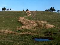 Trail
Trail Summit
Czarna Góra is very famous mountain given its importance, for the simple reason it is one of the most popular ski resorts of the Sudetes on the Polish side.
The name means "black mountain", just like the former german one (Schwarzer Berg). Despite being close to Czech Republic and that its name would be easily translated as "Černá Hora", the Czechs usualy do not so and keep the polish spelling, probably not to mix it in an already confusing crowd of homonyms. The polish name has also two, located respectively in Karkonosze and the Iser mountains, not to count a country name as well (what we call Montenegro).
Czarna Góra lies entierely in Poland and makes the northern extension of the massif of Śnieżnik (then, if we consider that Sněžník belongs to the Jeseníky, Czarna Góra does so). Its conic shape is recognized from far, especially when coming from the north and the Kłodzko road.
Apart from the ski resort, several things make Czarna Góra famous. There is a beautiful wooden outlook tower on top, which makes a fine hiking goal. A radio transmiter is also standing a bit below, and served by an asphanlted road, makes Czarna Góra a popular cycling goal. The traverse from Czarna Góra to Śnieżnik is also a rewarding hike made by many.
 Czarna Góra from Konradów
Getting There
 Śnieżnik from Czarna Góra
 Outlook tower view
 Keprnik from Czarna Góra
 Outlook tower view
Sienna, Kletno and Międzygórze are the usual starting points.
From Poland, all three are reached via Kłodzko if we come from Wrocław.
From Czech Republic, it is best reached from Oloumouc. While the Międzylesie border suits Międzygórze, passing through Kladské sedlo (Przełęcz Płoszczyna) is more adviseable.
View Larger Map
 Trail to Czarna Góra from Konradów
Routes
 Outlook tower
 Sienna Chapel
 Summit road
 South trail
 Outlook tower
* The most direct route is from Sienna, more exactly at the pass Przełęcz Puchaczówka where starts the red-marked trail going steeply south to the top.
* From Kletno, it is possible to catch the other end of this red trail starting with the yellow one.
* From Międzygórze, we can choose either to get to Przełęcz Puchaczówka via the blue trail, or the Kletno junction via the green one, in the half of which an unmarked track allows shortening the hike by reaching Żmijowa Polana directly. Both options involve a long hike.

 Vilage in the surrounding
Accomodations
 Konradów
 Konradów
 Sherperd hut
 Konradów
* Bicouacking, wild-camping: Czarna Góra is out of the Śnieżnik protected zone so in theory it is possible. Do do preferably on the south side, for example Żmijowa Polana
* Mountain huts: None, apart from the quite distant Schronisko na Śnieżniku
* There is a crowd of accomodations in Sienna, Kletno and Międzygórze :
http://www.czarnagora.pl
http://www.kletno.info.pl
http://www.miedzygorze.com.pl
 Panorama