


Comments
No comments posted yet.
Ever since I saw this picture of a tarn on Mt. Forgotten, I wanted to climb it. I did in 2003, but the thing was, when I got to the summit and looked northwesterly, I saw this one! I later figured out it was White Chuck and that was on my list too. Evidently, other things got in the way and conspired to keep me from even attempting it until 2011. I put it on my “birthday weekend” list to finally get done in 2011 but seeing that it was only 4 miles roundtrip with maybe 2100 feet of elevation gain, I decided I needed another one to do that day, especially if I was going to drive 5 hours from Portland to do it. After looking over the “Nearby Peaks” button on the White Chuck page, I saw Pilchuck. This is not one I would go out of my way to do, a walkup with only 2200 feet of gain and 5 hours from Portland, but combined it would be a good solid day and I could count two “Chucks” down. So, it was settled.
After sending out some emails to some of my “usual suspects” I found there were a few friends who wanted to join me. Ron (thundercloud) and I have done a half dozen or so peaks, Ian and I have done a few as well, and a friend through work Nina and her husband, Grant, were also interested. We decided to meet up at the trailhead and sleep there the night before to allow enough time to be able to do White Chuck in the morning and Pilchuck in the afternoon giving me enough time to get back to Portland before it got too late. I started driving about 7 pm on a Saturday night and was going to pick Ian up in Seattle and head out. Only Ian got sick with a fever so it was down to 4 of us. I ended up getting onto Road 2435, the final forest road to the trailhead sometime after midnight, following the directions from the White Chuck page (couldn’t find anything different on the net and Smoot’s book is vague-imagine that!) but those state you take 2435 to the end forking left at the last intersection. I started getting suspicious when the trees closed in and the young branches started scraping the sides of my truck. Then larger branches making scratching sounds down the side of my truck until I really was wondering what was going on. Then, I came to a large fir tree downed across the road and could go no further.
No one else around, had seen one car parked on the side of the road back farther but this was someone having car problems, not any in my party. (Triple A came and helped him the next day.) I decided to park the truck in an opening on this road and try to get some sleep. I’d wake up early and backtrack and see what I could find.
I got up, got ready and was moving before 6 am. I backtracked down the road but nothing. I then decided to come back and take the last road to the right to check it out and see if that was what Smoot refers to as the road to the trailhead. It did indeed turn out to be the correct one and shortly after 6 am, I met up with the others. Nina had seen me drive up the night before and figured I’d figure it out too. Ron apparently had the same issues but found it anyway.
We bypassed a few remaining snowfields and regrouped at a large boulder. After discussing it, it seemed the route continued up the somewhat exposed looking ledge system that wound its way up towards the summit. We knew at some point we climb to the actual ridge before the summit but not seeing any obvious way ahead of us, we assumed the summit was not able to be seen and would be around the corner on the ledges. Here we made two mistakes: the actual route climbs up towards the ridge exactly where we stopped via a grassy gully.
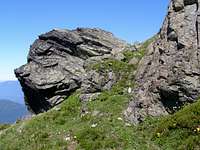
There are even some pink taped rocks here but they cannot be seen from below and this seemed way too early to climb up. Also, we actually were looking at the summit and the ledge system does not really wrap around the block ahead. But we did not know this so on we climbed….
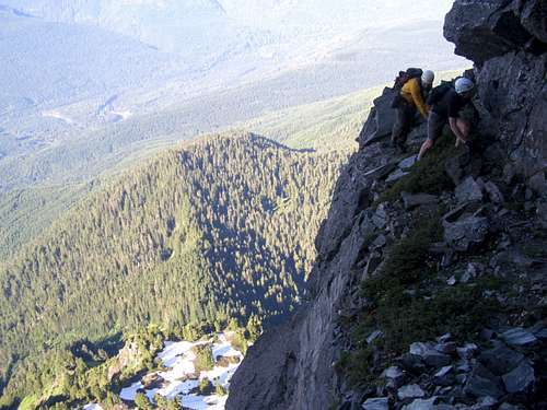
We made our way up these grassy ledges as they got narrower and narrower. As they did wrap around small outcroppings, we would have an occasional bit of exposure where, if you slipped and didn’t stop yourself it was several hundred feet of rock below to fall on. We managed to move through this fairly easily though until we came to a snow patch tucked into a notch in the rock. We were able to one-by-one scramble up the loose rock on the left of the snow and then hop over behind the snow into a moat that was now protected. The moat hid a shallow blocky cave. As we walked around the moat, we exited the cave and were back on even more narrow ledges. In some places, they were only a few feet wide before it dropped off hundreds of feet. Each step had to be sure here.
More of the same ledges followed until we made our way to another corner. Here the ledge system pretty much disappeared and we all had to agree, this was definitely not the right route.
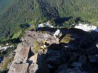
We pondered our situation and could see three options: climb ahead (but this now looked technical and we had no technical gear), go back and try to find the right route (but no one really wanted to do this unless we had to, we didn’t relish making those two moves we had just made in reverse), or try to find a way up from here. There was a shallow groove going up that looked Class 3-ish. Good blocky holds for hands and feet. Grant decided to scramble up and scout it. It was easy scrambling (slightly steep Class 3) and once he got up a bit, he said it looked like more of the same heading up. We decided to follow. We all scrambled up about 20 feet or so and the angle lessened. It appeared there was possibly a cairn above us. We continued scrambling up another 20 or so feet until it got to be hikeable again. Shortly after, we all were at this cairn and the summit of White Chuck.
One thing I did not mention much was how buggy it was. We sprayed and resprayed bug spray at least 5-10 times each this day. Skeeters in the trees and ledges. Large horseflies that looked like bees and sounded like hummingbirds wanted their blood too. Once we were back off the talus field and in the trees, we just kept moving as they were bad. We made our way back to the car at some point between 1 and 2 pm. All the wrong routes, slow scrambling on the ledges, retrieving of poles made this one go a couple hours longer than I had bargained for. So, by 2 pm when we were back at the cars and changing clothes, I decided I would not be going on to Mt. Pilchuck as that would just make it so late in the night getting home. My wife would be pissed, I’d be tired, etc. Of course, I did the next most logical thing, I opted for the remaining Chuck option – Ground Chuck! We went to Darrington and had burgers and shakes before the long ride back………………….
Note-I posted the correction on the road in to the trailhead on the main page and the new page owner, recently taking it over, has noted the correct directions and mileage.