
-
 31446 Hits
-
 72.07% Score
-
 2 Votes
|
|
Route |
|---|---|
|
|
40.59390°N / 111.7203°W |
|
|
scramble |
|
|
Most of a day |
|
|
Cl. 2 (south variation), and Cl. 3 (north variation) |
|
|
Approach
From Wasatch Boulevard, turn onto Golden Hills Drive and continue driving until about 8700 south. At the crest of the hill there is a small private road that joins Golden Hills Drive. Park here and start hiking up this road. At the end of the road is the trailhead.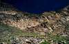 |
 |
 |
 |
 |
Stats
Distance: 4.29 mi (1-way, N Fork), 4.35 mi (1-way, S Fork)Elevation Gain: 6,105'
TH Elevation: TBA
Route Description
A reasonably well-defined trail criss-crosses the river, and eventually travels mostly along the north side of the north fork then crosses to the souoth before fading out 2 miles from the mouth at about 8800 feet. From here you can continue scrambling up either branch to reach the summit of the Twin Peaks. I took the south branch up and used the north branch for descent.The south branch is littered with burnt trees and ash covered ground left over from a fire that broke out here in the summer of 2002. Although it was difficult at te time to keep the kicked up ash out of my mouth, it should be pretty well packed down by now. A plus is that the burned forest makes for much easier bushwacking.
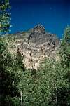
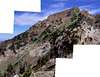
Eventually you'll come across a large talus slope. Looking at the north side of the branch, you can see a narrow talus slope that cuts through the cliff bands above. At the top of the cliff bands is a large boulder-strewn bowl with a cluster of pine trees in the middle. From here it gets more difficult to tell where to go. I scrambled up the middle of the east wall of the bowl to a narrow part in the cliff bands. Here is is a bit of a scramble for about 20 feet.
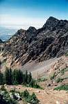
Since I didn't initially come up at the summit, I don't know exactly where to go from there, but what did work for me was to start hiking towards what appeared to be the highest part of the peak. If you miss the summit, you might have to drop a little ways back down the slope to circumvent some larger blocks that surround it. Searching below these blocks, a faint route can be seen. It is a modest scramble up the rock to the top.
At the top you can see the slightly higher summit to the east. It is about a 20 minute scramble along the connecting ridgeline to gain the main summit.
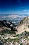
I descended via the north branch, which starts at the saddle between the two summits. A problem with going down this way is that there are about 5-4 rock bands you have to navigate from above, which makes them very hard to see. If you initially stay to the right side of the branch you can often find some chutes that cut through the cliff bands. You must srcamble straight down the last cliff band, though. The best place to do this is in the middle of the band, where it happens to be narrower. It is about a class 4 downclimb from here and then you're home free. Just descend the talus slope via a route of least resistance, making sure to stay close to the stream that forms, and you can soon regain the main trail.
 |
 |
 |
 |
 |
Essential Gear
Nothing apart from the 10 essentials is needed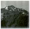 |
 |
 |
 |
 |
Dan Flynn - Jul 24, 2014 2:44 am - Hasn't voted
Deaf Smith to TwinsI just took the recommended route (south branch of north fork of Deafsmith) yesterday to the Twins and just wanted to add something to what was written by PellucidWombat: "I scrambled up the middle of the east wall of the bowl to a narrow part in the cliff bands. Here is is a bit of a scramble for about 20 feet. Since I didn't initially come up at the summit, I don't know exactly where to go from there, but what did work for me was to start hiking towards what appeared to be the highest part of the peak. If you miss the summit, you might have to drop a little ways back down the slope to circumvent some larger blocks that surround it. Searching below these blocks, a faint route can be seen. It is a modest scramble up the rock to the top." After that narrow part in the cliff bands of the east side of the bowl, keep more to the left than to the right. I went for the highest part of the peak, as stated, but at some point ended up going more to the right, which took me to a saddle between the west Twin and a smaller summit to its south. It was pretty, but I had to back down a ways and then aim more for the left. Except for the bushwhacking lower down the canyon, I highly recommend this route. Smooth sailing.