
-
 10606 Hits
-
 79.04% Score
-
 10 Votes
|
|
Route |
|---|---|
|
|
40.37920°N / 105.58439°W |
|
|
Hiking |
|
|
Spring, Summer, Fall, Winter |
|
|
Half a day |
|
|
Class 1 on-trail walk-up |
|
|
Overview
Roundtrip mileage: 6 milesCumulative elevation gain: 1,260 ft.
The Deer Mountain Trail from the parking on Hwy 36 a pleasant on-trail stroll to the summit of Deer Mountain which provides head-swiveling views of the high country of Rocky Mountain National Park.
 Mule Deer Yearling, RMNP
1 Mar 09
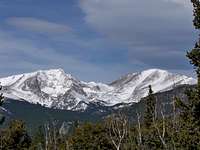 Northwest from Deer Mountain Summit
 1 Mar 09
This route to the summit is enjoyable in any season, suitable for all ages of solid hikers and is a great route for visitors to acclimate to the altitude before tackling higher elevation objectives. The trail is easy to follow and well-signed and does not require particularly cautious navigation. Be prepared after the initial end of the switchbacking climb, however, to persist across the rolling summit plateau prior to reaching the spur to the true summit.
Getting There
From the Beaver Meadows entrance of Rocky Mountain National Park, drive about 3.25 miles west-northwest on Route 36 (Foothills Hwy) to a wide area in the road with parallel parking on both the north and south sides.Note: Parking is very limited and this is a very popular spot, especially during the summer vacation season! To obtain a parking spot, either arrive early in the morning before everyone else, attempt to time your visit for the lunch hour or plan on an afternoon hike. (In the summer months, ensure your afternoon hike is timed after the afternoon thunderstorm.)
Route Description
- Leave your vehicle and find the obvious trailhead for the Deer Mountain Trail.
- Shortly after beginning your hike, you will encounter a trail junction. Stay to the right to remain on the Deer Mountain Trail.
- Follow the trail due-east for about 1/2 mile to the first switchback.
- The gently-graded switchbacks persist for about 1 mile and bring the hiker to the relatively flat summit plateau of Deer Mountain.
- Traverse for about another 3/4 mile across this gently rolling plateau.
- You will encounter a spur trail heading south toward the summit. Follow this spur trail for less than 1/2 mile to the rocky summit of Deer Mountain and enjoy the views!
 Click on map to enlarge
Essential Gear
- Trail map (either the Rocky Mountain National Park map obtained with entry or Trails Illustrated Map #200 covering the park
- Compass
- Colorado Atlas and Gazetteer (or similar atlas for finding the trailhead)
- Trekking pole(s)
- Sturdy hiking boots with grippy soles and stiff ankle support
- Water and snacks
- A camera to save memories of the high country views
- First aid kit
- Other standard backcountry essentials