Putrid Pete's Peak
Brian and Dane (two friends from NWHikers.net) decided to make for the hills since we all happened to have the Tuesday off work. Originally we had planned to do
Mount Washington but we quickly agreed to tackle something with "more meat on it's bones". We passed the map around in the car and settled for a lesser know peak call P3 (
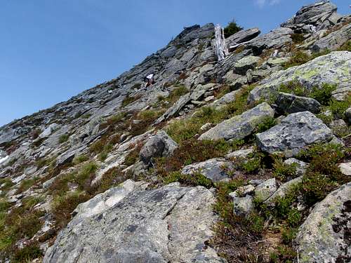
Putrid Pete's Peak). The trail head although hidden was not hard to find. The first mile we followed a well made trail through dense forest. Then we broke out of the trees and views of the upper Snowqualmie Valley filled out sight. The trail morphed into a boot path] and we scrambled up loose dirt and rocks trying not to dislodge anything large onto one another. The last 20 feet to the summit (5220 feet) involved a mild class 3 scramble.
At the summit the exposure to the north was a sheer drop off. We signed Pete's log and then Brian dropped the pen into a deep crack in the rocks. It's a good thing there was a spare pen. We discussed our options and decided that although we could descend via the same route we came up, steep loose terrain increased the chances of a minor injury. And besides, that ridge top leading over to Defiance looked pretty sweet. I had been on the summit Defiance a few times before. I told Brian and Dane about an old trail I knew of leading from Mason Lake straight back towards the car. We then agreed to attempt the traverse.
The Traverse
The beginning of the traverse was very steep with down sloping rocks and we had to move slowly. As loose rocks demonstrated, a fall here would be difficult to stop. Half way along, the ridge top widened and was snow covered toward the north in sections. We found the snow pleasant to walk on but had to watch for cornices and moat holes. Nearing Defiance, the tree cover thickened and we ascended the steep snow-covered west ridge 200 vertical feet to the summit (5584 feet). A nice view of larger peaks to the northeast and three frozen lakes down below restored our energy.
Mount Defiance
We descended from the summit along the steep south face until we reached the Mount Defiance trail. Having only planned to do the easier Mount Washington, I found that there were a few places I wished I had my ice axe along with me. The trail was still obscured by snow most of the way down to Mason Lake. When in doubt about direction, we followed the top of the east ridge that leads down to the lake plateau. A few short standing glissades added fun to this part of the trip.
Using my GPS I lead to the drainage of Mason Lake which turns into Mason Creek. I was looking for an
almost forgotten boot path that was shown to me several years prior by an old mountaineer. In the patchy snow we were not able to find it but we followed the left bank of the creek down. At times we got entangled in mixtures of slide alder, blown-down trees, and devil's club. Just as I began to fear that my two friends were cursing me under their breath I spotted the path. It was in bad condition and hard to see in spots but we were able to follow it all the way down to Ira Spring trail. This was the end of our loop. We covered a lot of ground without seeing the same things twice.
Comments
No comments posted yet.