Since at least 2009 the seeds of one day climbing Mount McKinley (as it was still officially named back then) had been growing in my mind. By 2010 having climbed both Mt. Hood and Mt.Rainer the itch had gotten pretty serious. Nevertheless it wasn’t until 2014 when I finally got the chance to do so. Over those four years I practiced sled hauling, did a lot of winter camping, and climbed a lot of mountains including 18,490 foot Pico de Orizaba in Mexico. I also improved my rock and ice climbing skills as well as my glacier travel skills, so as to be ready for Denali when the opportunity arrived and in March 2014 the opportunity arrived. March 16, 2014 I contacted thirteen people on Summitpost.org in regards to climbing Denali, and I ended up getting a positive reply from Art D of Texas. Art informed me that a team of three he was on for the end of May was in need of a fourth. I responded immediately that I was interested and Art passed the word along to his team lead, Calvin H of Colorado. By March 19 Calvin invited me to join his “Kicking Buttress” team and I accepted. In addition to Art and Calvin the other team member was Donald T also of Colorado. None of the four of us knew each other, so that was a slight concern, but we all had good climbing resumes and so it was worth the gamble.May 24 was the day the team was flying to Anchorage, with May 27 being the proposed date of flying from Talkeetna to the Kahiltna Glacier where the Denali West Buttress route begins. Thus from the time I joined the Kicking Buttress team I had only 65 days to arrange things on my end. First thing I need to do was to purchase my climbing permit as that needed to be done no less than 60 days prior to the climb start date (thus keeping the alternate team member slot open). March 22 I paid the $360 permit fee, and March 25 I booked a flight to Anchorage – as such I was one hundred percent committed. Over the next few days I finalized my needed gear list and anxiously began to buy gear. In the end I spent just under $2500 on gear, some I was able to find used, and the rest I found at discounted prices – not one item did I pay full retail price for.Calvin, Art, and Donald were planning to get together in Colorado at the end of April for a camping/mountaineer activity and to meet each other. I really didn’t see the need as I wouldn’t back out even if the team dynamics seemed wrong, so I told them I didn’t think I’d be able to make it. Instead I proposed chatting via FaceTime which we did end up doing when the three were all together in Colorado.
As soon as I committed to the trip I began walking around my neighborhood and up to the Y in Provo Utah with a loaded pack. I’d carry anywhere between 30 and 45 pounds of water. On the Y hikes I’d pour out the water at the top in order to save the strain on my knees on the downward slope. Other than that I didn’t do any special training for the trip.April 5th I did a ski tour up Mount Superior, across from Alta ski resort, and returned home in need of a nap. During my nap I woke up to discover the neighbor’s side of our duplex was on fire! I warned my wife, and then immediately set out to save my climbing gear, thousands of dollars of which I needed to return as I had decided on other gear. Happily, I saved most of the gear before the police escorted me out of the house. Initially I feared with a burnt down house, and all it was going to involved to restore it, that I’d have to cancel the Denali trip, still I was determined to go forward with it. Over the next few weeks we got settled in a temporary apartment and I worked with insurance adjusters as I continued to prepare for my Alaska trip.
Quickly May 24 arrived and I made the trip to Anchorage arriving at close to midnight to a well lite night sky. From the airport I made my way to the Hampton Inn where Art was booked into a room. I knocked on his room door waking him up and we meet for the first time. Within an hour Calvin and Donald arrived together as they had been on the same flight from Denver. The four of us shared the room, and the next morning we made our way to REI, AMH (Alaska Mountaineering and Hiking), and Wal-Mart to pick up our remaining food and gear items. In the late afternoon we had a meal at TGI Fridays and then returned to the motel room to pack and arrange the recently purchased items. It was quite exciting to think about what we four strangers were about to take on together.
Do the thing you have always wanted to.
Daily Journal
Moose at K2
Kicking Buttress Team on the Kahiltna Glacier
Trekking up the Kahiltna Glacier en route to Camp I
May 26 (Monday), Day 1: Talkeetna Taxi shuttle service picked us up at 6:30 a.m. from the Anchorage Hampton Inn and then we drove to another motel in Anchorage and picked up three Russian climbers and headed to Talkeetna. By 9:15 a.m. we arrived in Talkeetna 114 miles north of Anchorage. Our team had a 9:45 a.m. orientation meeting at the Walter Harper Ranger Station so we had plenty of time to drop off the Russians at Talkeetna Air Taxi and to drop off our gear at K2 Aviation. From K2, Elliot the driver and owner of Talkeetna Taxi, dropped us off at the Ranger Station which is located about a half mile from the K2 hangar. When we arrived Art realized he had left his phone at K2 so he returned for it and the remaining three of us checked in with the Ranger and each paid a ten dollar park entrance fee. Art made it back before 9:45 a.m. with his phone and after he checked in our team received the climbing orientation.Arriving at the ranger station about the same time as us was a British military climbing guide, named John, who informed us that he had just been in Peru climbing. He was hurried through a watered down orientation, a head of us, as he had climbed the mountain the year before. We learned that he was in a hurry to join the rest of a large British Military group that would be climbing the mountain.
Following the orientation we walked down Talkeetna main street carrying our CMCs (clean mountain cans) and made our way back to K2 to find a moose was feeding on their lawn. As my teammates went into the office to work out our glacier flight details, I entered the hangar to change into my climbing clothes and to repack my gear. They soon joined me in the hangar and it was set to fly out after lunch at about 1 p.m. We, along with our gear, were weighed coming in at about 300 pounds per person, although we were never told the exact weight, and by 1:10 p.m. we were in the air.
It takes around 30 minutes to fly the approximately 55 miles to the Kahiltna Glacier landing strip at 7200 feet elevation, and so we arrive about 1:40 p.m. By 2:00 p.m. our gear was unloaded and we had checked in with Lisa the Base Camp manager. It was a sunny and warm afternoon. A check of the temperature for that day shows Base Camp hit a high of 33 F (1 C). It is interesting to note that when the planes would land, while we were in Base Camp organizing our gear, they would bring down cold air with them and we would get a fleeting chill.We still had a lot of gear and food sorting to do, so we sat on the glacier and did that as well as digging a Base Camp food and fuel cache. In the meantime the British Military group arrived. Most of the Brits didn’t need to sort any gear, so they were on their way toward the 7800 foot camp before us. However John (the military mountain guide we had briefly met at the Walter Harper Ranger Station earlier) and his two rope team members, who turned out to be a female British doctor and a male army reservist, left just 10 minutes before us at about 5:20 p.m. as they lagged behind the rest of the Brits.
Our rope order was Calvin in the front, followed by me, then Art, and then Donald. Being in the back is the toughest position as leaving Base Camp entails descending 400 feet down Heart Break Hill. Pulling a sled downhill without rigid polls, when there is no one behind you to control it, is an inconvenience. Also if the last person falls into a crevasse he risks being hit by his sled as again there is no one behind him to stop it from following him into the crack. From Base Camp to Camp I at 7800 feet covers approximately five and a half miles, and we ended up following or being followed by John’s rope team the whole way. We encountered only a few open crevasses on the way but may have passed over many on just thin snow bridges. It took us 4 hours to cover the distance. The camp was in the shade of the surrounding mountains when we arrived and so we immediately bundled up to avoid catching a chill.At camp we set up our two tents, a two man tent to be used by one person, and a four man tent to be used by the other three. The idea with the tents was that we could all take turns in the small one thus providing us with some alone time. By the time we set up camp, and melted water, and prepared dinner it was 11:00 p.m. The next day’s forecast was for snow and since we didn’t rest at Base Camp we all agreed that the following day would be a rest day. I took the single tent that night.
May 27 (Tuesday), Day 2: We woke to fairly heavy snow falling. Also it was cold enough and windy enough that the tent poles were covered in rime ice. The rime ice indicated that the wind was from the south. In the morning no one was coming or going and as the first one up in our group I took the opportunity to meet Captain Josh A of the 1 Rifles British Military team known as the Alaska Bulge. I also noticed from a distance someone who looked a lot like a fellow I had climbed in Mexico with named Mike but I wasn’t sure. I mentioned Mike to my team members and told them about how he and I had tried to work out a Denali trip for this same year and how it hadn’t worked out. Later seeing the person again, still from a distance, I decided that it likely wasn’t Mike.
In time a group of Black Diamond employees arrived and talking with them I learned they were continuing up to the 9700 foot camp and that they were there to climb the Kahiltna Dome as part of testing out some new “top-secret” gear. After they continued up the snow seemed too lighted up, and soon others started to leave the camp, and we decided to also head up to Camp II at 9700 feet. In the morning Art had revealed he was having second thoughts about proceeding and was considering going back to Base Camp to fly out. Fortunately, he later decided he’d continue up with us to the next camp.
From Camp I to Camp II involves going up Ski Hill to just below Kahiltna Pass and it is often done as a double carry, but we decided to do it as another single carry. We left camp at 3:25 p.m. with wet snow falling, and visibility low, and covered the 2.5 miles to Camp II in 4.5 hours. It’s astonishing how much time it takes to go such a short distance when loaded down with heavy packs and sleds.
At 9700 feet it was cold enough that I put on my big Feather Friends parka as we shoveled snow and erected walls for our campsite which took an hour and a half to complete. It was midnight before we ate and after one a.m. when we got to bed. This time Art took the single tent.
For me the haul to Camp II was a much tougher day then the haul to Camp I and again we followed, or where followed by, John and his group on most of the trek. There were also some Russians on the trek at the same time as us who had trouble following the wands when they were in the lead.
Along with us camped at Camp II were the 1 Rifles Alaskan Bulge team (Brits), the Black Diamond group, a group of Columbians who we had met at REI in Anchorage, and a couple of Russian groups (one of which was from Australia).May 28 (Wednesday), Day 3: At 10:15 a.m. I hadn’t looked outside the tent yet but had the sense that it was a sunny day and so I applied sunscreen to my face and got out of the tent only to find it snowing rather steadily. With the snow falling all day we were able to get in a now much needed rest day; I will admit that my hips were sore from the two previous days of sled hauling. We improved the campsite by adding a kitchen and by 9 p.m. went to bed hoping to leave the next morning by 8 a.m.
Sometime during the day Art mentioned going down again. Hesitantly we all suggested that he go around the other campsites and see if anyone was heading down. Gratefully after a while he changed his mind and said he would continue up with us going only as high as he felt comfortable and if it wasn’t the highpoint then he’d wait for us to summit so we could all go down together. True to his word he never mentioned leaving again.
May 29 (Thursday), Day 4: Today found us still pinned down by the same storm from the south and as such we spent the day digging out the camp, melting water, cooking, and playing cards. BD pulled out and went down around 5 p.m. Prior in the afternoon I saw Mike arrive and this time there was no doubting it was him. He was chatting with the Brits and I assumed his team had decided to brave the storm and continue up to the 11,000 foot camp as I didn’t see them again that day. All our team was in good spirits today and Art even talked about summiting.
Still pinned down by the same storm from the south and as such we spent the day digging out the camp.
May 30 (Friday), Day 5: The storm continues. Waking up we found the tents buried in snow up to nearly the top. Again we dug out the tents and kitchen and played cards. I cooked Rice-A-Roni. Turned out Mike and group were camped here at Camp II but with the low visibility I couldn’t see them. I learned this as I noticed them in the late afternoon setting off in the storm toward the 11,000 foot camp. Mike, with his green jacket, I recognized from Orizaba, took the lead with several wands taped together to form one long pole sticking up from his back pack (this is an orientation trick, as such the rope leader can be used as a bearing landmark of sorts). Their exit prompted others to follow and at about 8 p.m. the Columbians headed up. It also seemed like some of the Russians took a cache up and returned.
Within camp the Brits built huge walls around their camp and rearrange their tent locations. A fellow from Ontario and his Romanian (I think) girlfriend from Maryland had dug out a camp spot a bite too close to ours, between us and the Brits; I don’t recall what day they arrived however. In spite of being pinned down I wrote in my journal “I love this experience”. At 10 p.m. the snow lighted up and I had a strong desire to pack up and head up, but the rest of the group was asleep.
May 31 (Saturday), Day 6: Our fourth day in Camp II. I had a good sleep and woke even now with the desire to travel. I was the first one out of the tent and the weather broke momentarily causing me to notify the others and prompting us to start packing. I was eager to start up even when the snow shower resumed but the others wanted to wait to see what the Brits did as they had sent out a reconnaissance team to scout out the path and conditions. When the Brits returns saying the trail was heavily wanded all but two teams pulled out of camp. The fellow from Ontario with his girlfriend had had two tent poles break in the night, so he announced that they would not be continuing, bummer for them, but he had been as high as Pig Hill a previous year.
We left at 3:00 p.m. en route to Camp III located at the base of Motorcycle Hill 1.5 miles away. The elevation gain from Camp II to Camp III is 1300 feet. We traveled in a storm again, and again John and his rope team leap-frogged with us the whole way up. As we went up we passed several groups coming down the mountain who reported they had not had a chance to summit due to poor weather. Many said they had been stuck at the 14,200 foot camp for as much as 10 days. I notified one of the descenders that his nose was white indicating the possibility of frostbite, or perhaps it was just sunscreen as a check of the weather for that day indicates temperatures as high as 35 F (above freezing) down at Base Camp (it would have been colder at 10,000 ft. most likely).
We arrive at the 11,000 foot camp at 7:30 p.m. and again had to dig snow and erect walls for a camp spot. It had gotten quite warm on the way up, in fact for much of the ascent I was down to a polyester shirt over a wool shirt, but once we stopped at Camp III it became very cold and being sweaty we felt it even more. It took two hours to erect a camp. We ate dinner at 11:00 p.m. and it was after midnight before we crawled into our sleeping bags.
Calvin took the single tent. Art had been in the single tent all four nights at Camp II so this was my first night in the same tent as him, and I was disturbed to learn that his only sleeping mat was an older air-mattress. I feared my friend was going to be very cold, as it seemed like our coldest night yet, and so I gave him my Feather Friends parka to put over his sleeping bag. I was plenty warm in my -40 Western Mountaineer bag, with both a high density foam and an air- mattress below me but nonetheless I still had a sleepless night.
Probing at 13500 ft before going off rope to dig a cache
June 1 (Sunday), Day 7: I woke with a stomachache and was out of the tent by 7:00 a.m. No one in the camp appeared to be up yet but shortly I saw Mike and group moving about. By 7:30 a.m. Calvin was up and him and I rebuilt the camp walls and added a large kitchen area. It was windy and cold till about 10:00 a.m. when the sun came over the ridges and soon folks were heading up Motorcycle Hill. By 1:30 p.m. we were hauling a cache en route to 13,500 ft. 1.75 miles away. On Motorcycle Hill we met two skiers from California (Eric and Galina). We had good traveling weather and reached our cache spot by 5:00 p.m. It was warm enough to wear just a fleece under a shell. No wind at Windy Corner. As we traveled up there were lots of people both going up and coming down. We were carrying small enough loads that we didn’t use the sleds this day.
On the way back to Camp III at the top of Motorcycle Hill just as we were about to started down it Calvin, in the lead, stepped into a hidden crevasse but only went in up to his knee. I watched it happen so when I approached the same spot, being the 2nd on the rope, I tried to avoid the concealed crevasse but I didn’t veer enough off Calvin’s path and my foot broke through, and so I stepped back and swung wide around the spot. We were back at 11,000 foot camp by 7:30 p.m., and it had warmed up significantly from the day before and wet snow was falling. I put on fresh clothes as I had worked up a sweat on the descent, and didn’t want to catch a chill.
A common concern by the last person on the rope is how his pace has to often match the speed of the rope rather than the best pace needed for the terrain. Donald, as the last on the rope, had to deal with that through a lot of the ascent. What happens is the people in the lead climb up a hill, for example, on to flatter ground and then proceed to walk faster on the easier terrain, but the people behind are still on the hill and the rope tights and they have to pick up the pace.
June 2 (Monday), Day 8: Seemed like a good day to move up to the Basin Camp, Camp IV, located at 14,200 feet but it took us until 3pm to be ready to go. I was in favor of using two sleds for the group but we decided on taking just one which seemed to be overloaded. As a result of taking just one sled our packs were full and heavy. Calvin was a real champion this day as he single handedly pull the overloaded sled all the way to the Basin Camp. I found the heavy backpack load to put a lot of extra strain on my feet which ached on the steeper sections of the route. We were slower than the previous day as we did not pass our cache spot until 7 p.m. From the cache at 13500 feet to the 14K camp is 1 mile and 700 vertical feet but relatively easy walking and it took us about forty five minutes to cover it. That section of the route had a few open, albeit narrow, crevasses.
As we wandered into Camp IV the first people we saw were the couple from California and we spoke to them briefly before setting off to find a camp spot. Once again we had to dig snow and build walls and it took us till about 9:30 p.m. to complete that and get the tents up. It was again cold and I wore my big Feathered Friend parka the temperature were around 0F (-18 C) at that time of day. We didn’t eat until 11:30 p.m. and we went to bed about 12:30 a.m. Donald took the single tent.Many groups at the Basin Camp had been there for more than a week, waiting for the weather to break in order to get a chance to move to the High Camp. What really stood out is how many of them had major goggle tans.
The National Park Service maintains a spreadsheet of observed weather conditions for 7200 feet and 14200 feet, however it is incomplete and appears to contain self-contradictory data. With that said, consulting it reveals the coldest temperature at 14200 feet while we were on the mountain occurred June 2 at 8:00 a.m. when it was -27 C (-16 F). In contrast the warmest temperature at 7200 feet while we were on the mountain was 1.6 C (35 F) on May 31. The highest wind speed at 14200 feet while we were on the mountain was 48 mph (77 Km/hr) recorded on May 30. Wind speed and temperature for our summit day were not available. The weather higher on the mountain varies greatly from that at the relatively protected Basin Camp at 14200 feet, and undoubtedly reached much lower temperatures and higher wind speeds.
June 3 (Tuesday), Day 9: It was a cold night, but again my -40 bag was plenty warm. My dilemma with the -40 bag was whether to keep my head in or out of the bag. If I had it in, my body would over heat and perspire, but when I left my head out it would get cold. In the end I ended up abandoning the silk liner and opening the zipper a foot or so at the feet to allow air flow. Doing so helped to regulate my temperature allowing me to have my head inside the bag. I again loaned Art my big parka to place over his bag.
The day warmed up significantly once the shadow of the mountain receded at about 10:00 a.m
The day warmed up significantly once the shadow of the mountain receded at about 10:00 a.m. I scored food from a departing group and then proceeded to trade some of it to the Brits for some fuel. Armed with the food and fuel we didn’t have any need to go down to 13,500 feet to retrieve our cache, meaning we could stay in camp and use the day as a rest day. I had a headache from both the altitude and a poor night’s sleep as well as from not eating enough so I welcomed a day off. Due to the heat reflecting off the snow it ended up getting “super hot” during the day even though the ambient temperature was -5 Celsius.
In the late afternoon the rest of my team roped up and walked the quarter mile over to the “Edge of the World” to catch the view back to the Kahiltna Glacier and the plane landing strip, but I elected to stay in camp and enjoy the alone time. It stayed relatively warm out and sunny until about 7:30 p.m. when the shadow of the mountain again covered camp.
We learned that no one on had gotten onto the Kahiltna Glacier after May 26 for about 5 days, as such it was very lucky that we had arranged to get out May 26 rather than our planned May 27 date. Sure we had been pinned down at 9700 feet for several days but at least we were on the mountain and acclimating rather than being stuck at nearly sea level in Talkeetna.
June 4 (Wednesday), Day 10: I got up around 7 a.m. and it was extremely cold so I soon returned to the warmth of my sleeping bag. By 9 a.m. it started to warm up and by 10 a.m. it was again “super hot”. I made breakfast, for our team, of freeze dried scrambled eggs to which I added some of the canned beef I had scored the day before. I made my share into two wraps.
After the late breakfast the four of us roped up and walked down to get the cache at 13500 feet. It only took 20 minutes to get there and 40 minutes to get back to camp after retrieving the cache. Art had decided the 14200 foot camp was the end of the line for him. So when we got back to camp Calvin, Donald and I practiced fixed line travel, boot ice axe belay, and ice axe carabineer belay techniques. It was another clear, hot, sunny day identical to the pervious one and we speculated that a lot of folks were finally reaching the summit; rumor later had it that as many as 100 people summited this day (until then the summit percentage for the season was 20% or lower with only 15 people having reached the summit the day we had our orientation).
We decided to take advantage of the weather and move a cache up the headwall to the col at 16,200 feet. Art, who would stay at 14K camp, informed as that he would try to talk to the volunteer doctor stationed at the Ranger camp as he was having a problem with his tongue which he suspected was sunburn. Calvin, Donald and I set off at 5 p.m. with four days of food to cache. It must have taken about 1.5 hours to reach the fixed lines where the snow turned to blue ice and the slope steepened to 55 degrees. It was fun to go up the lines, and it was my first time using an ascender, and by 7:30 p.m. we topped out on the col. Of course this is the time of day it begins to get significantly colder on the mountain so we had to bundle up and get the cache dug quickly. Going down the fixed lines was no fun at all, and trying to use an ascender on a descent is not advisable; I tried it but soon abandoned it and switched to the arm wrap technique which marked up my coat sleeve and burned the palm of my mitten. I neglected to time the descent but it was slow going down the fixed lines.
Ahead of us on the fixed lines were a couple of fellows who had been stuck at the Basin Camp for 12 days. The day we arrived at Camp IV one of them, the Indian fellow (dot not feather), had fallen into a crevasse, unroped, just below the fixed lines, I asked him about that and he said his team dropped an axe to him and he was able to climb out.
Upon are return Art cooked us spaghetti; it was the second night in a row for spaghetti.
Note about meals:Our meals were arranged on a three day repeating schedule, which was helpful for buying the food but which we didn't necessarily stick to on the mountain. Our three breakfast choices were freeze dried bacon and eggs with freeze dried yogurt and dehydrated apples, or instant oatmeal with freeze dried pineapple, or granola. Herbal tea, and/or hot chocolate was also part of breakfasts. For lunches we had bagels, wraps, salami and cheese, or snack food such as trial mix or potato chips. Our dinner menus were either pre-packaged freeze dried meals, or Rice-a-Roni, or angel hair spaghetti with pesto and parmesan cheese. Granola bars, chocolate, hard candys, and similar snacks were also part of our diet. There were a few limited variety items like couscous, Ramon, beef jerky, freeze dried desserts, and fig newtons. Our diet was satisfactory, but supplementing and varying it with items obtained from other teams was appreciated.
June 5 (Thursday), Day 11: It was a rough night for me and I was half tempted to leave the tent and try to sleep in the kitchen. It was a warmer night then the previous one and perhaps that is why there was a lot of snoring going on. During the night the back of my hands hurt, seems they got sunburned yesterday as I had my gloves off during the day.
My thumbs cracked days ago from the dry cold air (I think the first one cracked about the time we left the 11K camp as I remember it bleeding when we arrived at 14K) and several of my fingers have also cracked. The cracks bleed and they hurt. I had to tape up both my thumbs.
Later in the afternoon Donald told me he’d like to get out of the single tent so I traded spots with him. With only one person’s body heat it is much colder in the single tent then in the group tent, and that is when my extra warm sleeping bag was welcoming.
With a favorable weather forecast for the next couple of days we are planning to move to high camp at 17,200 feet tomorrow and to go for the summit June 7. I’d like to leave earlyish tomorrow so as to arrive in high camp before it gets really cold at 7:30 p.m. It’s snowing today.
June 6 (Friday), Day 12: We didn’t leave for high camp until 12:45 p.m., riskily late in my judgment. June 4 it took us 2.5 hours to reach the cache spot on the 16K col but today it took us 3 hours and 15 minutes – there were lots of groups out and that slowed us down as did our heavier packs. After digging up the cache we decided to just take enough food for that night, and for the next day, and for the following day’s breakfast, even though in the cache we had four days’ worth of food for three people. As such we were really banking on making the summit on June 7 and being able to get back to either the 16K cache or the 14K camp June 8. It was a gamble but our loads were plenty heavy and our packs were plenty full so it seemed worth it. From the cache it took 3 hours to cover the 1000 feet up the 16 K ridge, past Washburn’s Thumb, and over to Camp V at 17200 feet. I had read that climbers should plan on covering only 300 vertical feet per hour at the higher elevations and that was about our speed.
From the cache it took 3 hours to cover the 1000 feet up the 16 K ridge, past Washburn's Thumb, and over to Camp V at 17200 feet.
Its 1.75 miles from Camp IV to Camp V and we arrive at 7:30 p.m. It was cold but calm and sunny and it seemed like the shadow that covers 14K camp at 7:30 p.m. would not reach Camp V for a while, so we wandered over to the top of the rescue gully and took a few pictures of the 16 K ridge, as well as Basin Camp below with Mt. Foraker behind it.
Not long after our arrival at 17,200 feet the couple from California arrived. I was surprised to see they planned to use a Jet-Boil stove. By 9:30 p.m. we had camp set up, it went quite quickly as we were able to modify an existing spot. During the night Donald woke up and complained about having trouble breathing. I explained to him that that was to be expected as at our elevation there is only 50 percent the amount of oxygen as there is a sea level – the air was thin! At that elevation it one must inhale twice to obtain the same amount of oxygen of one breath taken at the sea.
June 7, 2014, HP #16 of the 50 US State Highpoints
West Buttress Camps 3, 4, & 5
June 7 (Saturday), Day 13: Summit day! I was up at 8 a.m., but it was 11:45 a.m. before we set off for the summit. Leaving earlier than we did is advisable. For emergencies between us we carried a sleeping bag, a matt, a stove, 3 pickets, an extra pair of crampons, a snow saw, and a shovel. Additionally we each carried extra clothing, food, and water - I really wanted to take three liters of water but it is very time consuming to melt water and so I settled for just two liters. We all wore our insulated pants, shell pants, overboots, and multiple layers on the top half of our bodies. My upper body clothing was a toque on my head, a neoprene mask for my face, two wool shirts, a fleece jacket, a down jacket, a water proof wind proof layer (gortex), goggles, and double layer mittens. In my pack I also carried a down parka, summit mittens, and a neck gaiter.
From high camp the route heads NE (mostly east) along the steep “Autobahn” toward 18,200 foot Denali Pass. This section does not get sun until the afternoon and so it is extremely cold, and hence most avoid really early starts out of Camp V. This day other teams had started up the Autobahn by 10 a.m.
The Autobahn has a steep dangerous fall line to climbers left and has been the site of many Denali accidents so as we went up we took advantage of pickets in place and clipped our rope to them. Calvin again was in the lead, with me in the middle, and Donald taking up the rear. We might have been roped up a bit too close together as occasionally the pickets were too far apart and we’d have to travel without protection. During those times, I’d yell out “no protection” just so all of our rope team was aware. It was too cold to reach inside my jacket to get access to the watch I keep in my camera case so I didn’t time land marks or take photos on the way up. A couple of climbers descending Denali Pass crossed paths with us as we went up, and for a while another group was at times close behind us (however after Denali Pass we never saw them again, and we were basically alone).
Calvin at 20,320 ft.
Perhaps three quarters of the way up Denali Pass Kilian Jornet booted past us – I didn’t think he was moving extremely fast, and I watched him as he got near the top of the pass, took off his crampons and put on his skis, and then disappeared. That day he set a new speed record reaching the peak in 9 hours 45 minutes from Base Camp and descending in 2 hours and 3 minutes. Just as we were going up the hill (part of the ridge of Archdeacons tower) which you traverse to get down to the football field Kilian came zooming by skiing down, this time he really was moving fast. We also saw his skin track in several places as we ascended mostly between the top of Denali Pass and Arch Deacons tower. Today wasn’t our first time seeing Kilian either as he had passed us somewhere near Windy Corner on one of the day we had passed through there.
It was inspiring to reach the top of Denali Pass where we turned south toward Arch Deacons tower, but it was rough to find out how steep sections of that part were. At the apex of Denali Pass we had a decent view directly east of the Harper Glacier - which on first sight I thought looked like the football field (but that was still a long ways off). Although we couldn't see it Denali's North Peak is only 1.3 miles (2.1 km) NE (at 39.2 degrees) of Denali pass.
After Kilian passed us on his way down, we had the false impression that we were nearly at the top of North America, as we thought a point to the right of the Archdeacon ridge you traverse to reach the football field was the top. But alas we were wrong, and we still had a long way to go across the football field, up Pig Hill, and across the summit ridge. As we got on the football field, at 19,200 feet, the winds really picked up, and I kept hoping in vain that they would die down but they never did. The section the route crosses of the football field is about a quarter mile long and leads to the base of Pig Hill. Pig Hill is the sloped face of the Kahiltna Horn. I hadn’t read any detailed information about Pig Hill but its name says it all; what a pig of a hill and at over 19500 feet it is really tough going up its’ 500 feet to just below the apex of the Kahiltna Horn where the Cassin Ridge meets the West Buttress route.
Going up Pig Hill we met the guide camped next to us at 17200 ft. who was short-roping down one of his Japanese clients. He offered words of encouragement. Another guide was bringing down what I assumed where Russian clients. At the top of Pig Hill just as we turned to the left and started on to the quarter mile summit ridge we encountered the rest of the Japanese team descending.
The winds were strong along the summit ridge, and we had to be aware not to get blown over. We trudged along on the left side of the summit ridge as the right side drops over 8000 feet down to the east fork of the Kahiltna Glacier. At 9 p.m. (9 hours and 15 minutes after leaving Camp V) we reached the top of North American at 20,320 feet. All I could think about was getting down, as the weather was bad. I snapped a picture of the summit marker, and one of Calvin at the marker, then had him take a photo of me, followed by a selfie. I also got a photo of Donald approaching the summit, as he was the third one on the rope, and a picture of Calvin’s watch to document the time. We couldn’t have been on top for more than five minutes and all my photos were taken within the same minute (9:02 p.m.) before my camera could freeze. The views were obstructed by blowing snow, and so we didn't even try to identify any landmarks.
Walter at 20,320 ft.
Coincidentally, we reached the south peak summit on a Saturday, the same day of the week as the first expedition did, and exactly 101 years, to the date, after the first.
I had worn a face mask on part of the ascent, don’t recall when or where I put it on, and at times I had to pull it down because due to the lack of oxygen (and perhaps also due to the smothering effects of the wind) I felt like I was suffocating. On the way down the face mask froze up and I had to switch to my neck gaiter. To avoid frostbite on my face I’d often place my gloved hand on my nose and cheeks. The winds were gusting extremely strong as we descended, blowing up a lot of snow and reducing visibility to 20 feet or less; likely it was probably also snowing.
I hoped that once we turned to go west down the Autobahn that we’d get out of the wind but in fact it just got worse. On the Autobahn I felt like we could really be in trouble and wondered if we were going to make it down without an accident. Fortunately those other teams we had seen coming down Pig Hill and off the summit ridge were in front of us and now and then we could still find their tracks and very rarely we could see them. Eventually we caught up to one group which was a big relief to me, and at 1 a.m. we rolled back into High Camp dehydrated, hunger, and too tired to solve either. I had some ice in one of my bottles so I put the bottle in my sleeping bag to melt overnight, popped a hard candy into my mouth, and lay down to sleep glad to be back at camp and happy we had made the summit.
June 8 (Sunday), Day 14: The cold and wind gusts of the evening before continued today. We ate Mountain House dinners for a late breakfast and broke camp at 2:30 p.m. We got down the 16K ridge in 1.5 hours and retrieved our cache. The fixed lines were even tougher this time, due to our loaded back packs, and it took an hour to descend them. I ended up trying the ascender again, as I was wearing finger gloves, but changed to just a safety on the line and walking down face into the mountain just as I would if not on a fixed line; this worked much better than the other methods I had tried. It took two hours to get back to Basin Camp from the 16,200 foot col.
Once we got off the fixed lines the clouds burned off and the sun came out making it feel hot and I worried about getting a sun burn. Arriving to the relative comfort of 14,200 ft., and our established camp felt really nice, and there it was lightly snowing. It was good to see Art and to report our success, and he was happy to see us too. We were all tired so we had Art melted snow for us for water to drink.
Kicking Buttress Team Return to 14K after Summiting
June 9 (Monday), Day 15: To lighten the load for our pending descent we gave away a lot of our extra food, and it turned out most of it went to Mike and his party. In the early afternoon as Art and I were roping up to go over to the Edge of the World Mike stopped by to congratulate me. I wished him luck on his summit attempt as well. By 2:00 p.m. the day was turning from warm to stormy and after we got back from a viewless Edge of the World we packed up hoping to get out before the storm arrived. This was supposed to be a rest day but that had now changed. We made it down to the 13500 foot cache area when the weather really started to deteriorate, and we passed a tired looking group who were going up. Their guide informed us that there were a lot of snow pillows after Windy Corner which would mean trail-breaking for us and that turned out to be very true.
From Windy Corner down to the Camp III at 11,000 feet the winds were very strong, and it was snowing steadily. I was the third guy on our rope, behind Donald and Art respectively, and many times I could not see Donald. Luckily there were wands in place and we were able to find our way down using them. I had the side zippers of my pants unzipped to the knees for ventilation and without stopping and using both hands it’s not possible to zip them up all the way so I was getting a lot of cold air circulating around my behind – I remember thinking to myself “you are literally freezing your ass off”.
Right around Squirrel Point one of my crampons came loose and fell off. To get it back on was a big ordeal as it required removing my pack, securing that to avoid losing it, then cleaning snow off the boot, removing my gloves and reattaching crampon. The adjustment on the crampon was frozen and so I was unable to tighten it, but luckily it stayed on for the rest of the descent to Camp III.
Before arriving at Motorcycle Hill I was worried that it would be loaded with snow and as such a major avalanche concern (it has slidden in the past and caught and killed climbers in 2011), but luckily the hill was on the windward side and the new snow was blown off it. It took us 3 hours to travel from Camp IV to Camp III a distance of 2.75 miles. Once again Calvin singlehandedly managed our only sled.
With the storm it was obvious that we were going to stay at Camp III. As might be expected the camp spot we had built eight days earlier was of course taken, but we found an open one, with existing walls, on the north end of camp. It’s a tad risky camping at the north end of Camp III as the headwall above it (which is located to climbers left of Motorcycle Hill) has been known to avalanche and our camp spot was not below any protective rock bands. However it was the only prebuilt spot free and we were too tired to set up another camp spot. I took the single tent and wrote in my journal at 11:30 p.m. as the others played cards next door.
June 10 (Tuesday), Day 16: I slept late until 10:00 a.m. at which time I looked out to find it was still snowing and very windy. Lots of moisture had built up over night in the tent as it is a single wall, so my down bag was quite moist but still insulating fine. My stomach was again bothering me, but along with the rest of our team I ate oatmeal at noon.
In the afternoon some Russians came down from Camp IV and asked if they could rest in our kitchen. They told us they had come down to get their food cache as they had run out of food at the higher camp. We still had a lot of extra food so we let them take what they wanted of ours. Before the Russians came down a Japanese group made it down from 14K and while on Motorcycle Hill they made a false “Avalanche” claim alarming those of as at Camp III who heard the bogus declaration. In the early evening the Russian returned, as we played cards in the big tent, and asked if we had any extra sleeping bags and/or pads (of course we didn’t). Turns out the Russian couldn’t make it back to 14K due to the storm and so they were stuck at 11K – I’m not sure how that turned out for them.
Getting pinned down on the descent was wearisome and the Beach Boys song “Sloop John B” with its “Let me go home, I wanna go home” lyrics kept going through my mind. I was hoping the weather would break and we’d get the chance to continue down but neither happened. We spent the day shoveling, napping, and playing cards. For dinner Art and I cooked couscous with a tomato sauce.
June 11 (Wednesday), Day 17: Today was clear and many groups were heading down including many coming down from higher camps. I packed up expecting we’d all want to do take advantage of the weather and head down too, and Calvin came over and informed me that we were going to stay in camp all day and leave at 1 a.m. The idea was to avoid having to set up camp again at Base Camp should we not be able to make it down in time enough to get a flight out. A reasonable idea but I felt it was shrewder to travel while we knew the weather was good and also during the day when the temperature is warmer. Nonetheless we used the day as a rest day, and as we rested I heard planes flying all day, undoubtedly dropping off and picking up climbers from Base Camp, even as late as 10 p.m.
I spent the day mostly napping and reading. We had extra food still, and I was hunger, so I cooked up some group meals and we ate a lot. Additionally I watched climbers going up and down Motorcycle Hill, and for a while there were even some skiers doing laps on the terrain to the right (east) of the Hill. The skiers worried me at first as the terrain looked very loaded with fresh snow and I didn’t want to see it slide, but they had fun and no incidents occurred. At one point a snowboarder came through camp. By 10:30 p.m. when Art and I were preparing a late dinner the camp had mostly cleared out, and the temperature had really gone down. During the day I’d seen many groups I recognized from the 14K and higher camps pass through.
June 12 (Thursday), Day 18: We didn’t make it out of camp until 1:45 a.m. in very crisp cold weather. Luckily the wind was absent. I had on my wool long Johns under my insulated pants which were under my shell pants, as well as hand warmers on my ankles (to assist in keeping my feet warm). I also wore and all my coats (fleece, GoLite down, shell, and FF parka).
As it turned out the rope order became Donald and his sled, trailed by Art’s sled, then me and my sled followed by Art and Calvin’s sled, and lastly Calvin. On the downhill the last on the rope doesn’t pull a sled as without rigid poles there isn’t any efficient way to prevent a sled from running into him. It might seem like being behind two sleds, on the downhill, would be a lot of work to hold them back but since the gradient of the terrain we were on wasn’t extremely steep, and with new snow on the path to slow the sleds down, the sleds only required occasional attention from there follower. Conversely being in front of the two sleds was probably the toughest position as it required some extra pulling effort when sections of the terrain were either flat or from time to time uphill (especially going up Heart Break Hill).
The journey down started out a bit sloppy as members of the rope team were losing snowshoes and sleds were tipping over. Donald realized the seriousness of the situation when he mentioned that if he had to keep stopping that he risked getting frostbite. And so, not long after we left Camp III, he and I repacked his sled, as it was apparent that it was going to continue to roll over, taking Arts sled with it, if something didn’t change. Once we got the sled repacked the voyage down changed to incredibly enjoyable, but before that I was glad no other groups were out to see our temporary disarray. With steady uninterrupted travel we soon warmed up and I was able to remove my parka and shell leaving me with just the fleece and Golite jacket and I was comfortable even though the packs and sleds were covered in frost. Occasionally Donald, who was wearing his overboots, would lose a snowshoe, but for the most part the remainder of the trip down was smooth.
The section between 11K and 9.7K camps is known as “Land of the Ghost Wands”, and even though a lot of the wands were covered up due to all the fresh snow there were at times multiple paths through this section – when we’d get to a situation like this, I’d ask for unanimous group agreement on which way to go before we’d proceed. Typically the branching paths would later reunite.
It felt great to be the only ones out, as though we were the only ones on the mountain. We walked toward a full moon, and of course it stayed light all night as it does up there. At one point the full moon was out, and there was also alpenglow on the mountains; I wondered if that can happen at lower altitudes where the sun actually sets. It was so still and quiet, with no one else around and no shuttle planes flying, so peaceful. So even though I was initially against traveling at night, it ended up being an amazing experience.
I had estimated the time to travel the 9.5 miles from Camp III back to Base Camp to require 6 hours. As it turned out we arrived in Base Camp at 8:00 a.m. Going up the 400 vertical feet of Heart Break Hill had taken an hour putting us just 15 minutes over the six hour estimate. On the way down we didn’t cross any open crevasses; with all the new snow they were all covered.
Upon arrival at Base Camp we pulled the sleds up near the door of the Base Camp managers hut, she (Lisa) opened her door and asked our group name and what airline we were with, and a few minutes later she announced K2 would be by to pick us up at 9:30 a.m. Our timing had worked out perfect but nonetheless I was exhausted from the lack of sleep.
Once I got my snowshoes and harness off and my sled unpacked I grabbed my shovel and went to work digging up our cache. The cache was deep plus there was a lot more snow over it then when we buried it so it was a lot of work. With all the caches in one spot and marked I thought it seemed a lot like a graveyard. I had dug down to the cache when Art and Calvin arrived to help and they finished off the removal.
Kicking Buttress Team at Base Camp before flying out. The peak directly behind the climbers is Denali.
It wasn’t until 10:15 a.m. that the first K2 plane arrived. The park rangers were also waiting for K2 so we didn’t know if they’d go first or not, but we ended up on the first K2 plane along with two Canadian fellows named Liam and Brian. As it turned out Brian was the snowboarder who came through Camp III the afternoon before. Also I realized we had seen Brian and Liam attempting to skin up the rescue gully the day we were going for the high camp. It’s kind of a small world on Mount McKinley.
On the 30 minute return flight I was so tired that I dozed off. Back in Talkeetna we checked in at the ranger station and reported our success, returned the CMCs, and ate a burger at the Twister Creek – I was too tired to remember the order of those events. In the afternoon K2 shuttled us to their bunkhouse and Calvin, Art, and I set up clothes lines and hung out our gear to dry. After showering we headed back into town for pizza at Mountain High. Donald ended up ordering the biggest calzone I have ever seen, and he finished 90% of it, while Art, Calvin and I shared two large pizzas.
While at Mountain High a couple from Illinois came in and when they learned we’d climbed the “High One” they chatted with us for a while. After such a long day I was literally too tired to sleep and the others must have been the same as we stayed up at the K2 bunkhouse and taught Liam and Brian, who were also staying there, how to play 31. We played just for fun, and I ended up winning. Around midnight I went to bed.
June 13 (Friday), Day 19: I was in a bunk room with Art, Liam and Brian, and they got up about 9:00 a.m., but I stayed in bed till 11:00 a.m. Soon after I got up Donald, Calvin and I strolled over to the Roadhouse to meet the other three for breakfast. I called my wife on Arts phone to let her know we had made it up the mountain and were back down safely and in Talkeetna, she seemed surprised. An older couple from Ontario was seated at the same table as us and they were very interested in our Denali experience. Calvin put one of his “Kicking Buttress” stickers on a pillar which we then posed in front of for a photo. After breakfast others, from another table, who had overheard our story, ask if they could take our picture.
Following the Roadhouse we went over to the Ranger Station to watch the 17 minute film about climbing Denali called “Climbing Mt. McKinley”. After Calvin looked at a pick-up for sale, hoping to rent it, while Donald went looking for souvenirs and Art and I wandered over to the library to use the Internet to check on changing our flights home. I was disappointed to learn how expensive it would be to change my flight. That evening we went to the West Rib for burgers, and Donald treated us. After dinner he had to hurry off as he had been lucky enough to arrange a cheap flight back to Denver for that night.
June 14 (Saturday), Day 20: In the morning I returned to the Talkeetna library to again check on flight prices but they had only increased even more so I decided I’d stay in Alaska sticking with my original flight which would leave early on June 22. Art was able to change his flight, and he caught a shuttle to the airport at 2:30 p.m. on the same shuttle, I believe, as Liam and Brian.
In the early afternoon I ran into the owner of AMS (Colby Coombs) and asked him if his business rented tents, he said no but that he had one he’d sell me. I told him I’d drop by AMS later if I decided to get it.
Later in the afternoon, after Art had left four climbers arrived at the K2 bunkhouse fresh off the Kahiltna Glacier. Two of them were the couple from California, Eric and Galina; the other two where two more Canadians, actually the other half of the Brian and Liam group, namely Ally and Andrew. Calvin and I hung out and chatted with the four of them and exchanged Denali stories. It was pretty funny at one point when Galina was teasing others about their goggle tans, and everyone just looked at her and then someone told her that she had the worst one – seems she hadn’t looked in the mirror yet. I reminded Andrew that he had given me some gummy bears on the headwall just below the fixed lines on June 6. Later Ally, Andrew, Calvin and I went out for Thai food. Following dinner Ally, Andrew, and Calvin went to Twister Creek Restaurant and I went over to AMS and bought the tent. Then I took the tent to the K2 bunkhouse and cleaned it up and got ready to head to Denali National Park and Preserve the next day.
June 15 - 19, Days 21 -25: Traveled to Denali National Park and Preserve. Spent the first full day in the lower part of the park at the visitor centers, etc. Next day I rode the camper bus to Wonder Lake, and I finally got to see Mt. McKinley. After camping at Wonder Lake I returned to the Riley Creek Campground, and the next day took the Alaska Railroad back to Talkeetna.
June 20, Day 26: Traveled to Anchorage from Talkeetna and got a bed at the "Basecamp" hostel (formerly known as "The 26th Street Hostel").
June 21, Day 27: Toured around Anchorage. Met a Romanian climber at "Basecamp" who got some serious frostbite on Denali. In the evening I took a cab to the airport.
June 22, Day 28: Overnight I fly home to Utah.
July 3 (Thursday), 12 days after leaving Alaska: Today I stumbled across my summitpost.org “plans and partners” post from January 28, 2013, where I was advertising my desire to get a team together to do the West Buttress in June 2014. Click here to read it. SummitPost.org’s system doesn’t email you when someone responds, and so I only found out today that Calvin (aka Charmann) had replied on Dec 13, 2013 9:42 pm saying, “Still looking? I'm interested in getting in on a group or putting one together. I thought I had a team but they seem to be flaking and I need people who will commit or need someone committed for late May/early June. I'm looking to do the west buttress.... Please let me know if you're interested!!”.
Here is Art’s (aka Reachigh2014) post which I replied to March 16, 2014.
Summary
I've been asked, since I got home, if I had fun climbing Denali. Sure, there were lots of moments of fun during the experience, but I don't think it is correct to say that mountain climbing is fun. With that said, I don't mean to imply that mountaineering isn't enjoyable. Of course I enjoy it, in fact I'd go so far as to say it's what I like the most in life, but nevertheless so much of the sport of alpinism is hardship and suffering. That seemingly inverse relationship between enjoyment and hardship seems to be a large part of what draws mountaineers back into the mountains time and time again. There is pleasure in working hard, and mountain climbing is mostly hard work which I hesitate to call fun least I cheapen it.
There were several times during the climb when we talked about how nice it would be to be done, or how we hoped to summit on this trip so we wouldn't have to come back. Yet we consciously knew, and even said, that once the experience was done, and we'd had a bit of time to recuperate, that we'd be up for it again (whether it be climbing Denali again or any other mountain). I think this might have been what Jim Whittaker meant when he said about mountaineering that it "is like hitting oneself in the head with a hammer - it only feels good when you stop." Similarly Wojtek Kurtyka said, "Alpinism is the art of suffering", and Chip Brown said, "Anyone who climbs [mountaineering] understands the relation of pleasure to risk and the great joy of escaping hardships you have brought upon yourself." Also in "Mountaineering: The Freedom of the Hills" it states, "mountaineering is more than climbing, panoramic views, and wilderness experience. It is also challenge, risk, and hardship. And it is not for everyone. Those drawn to the mountains can find them exhilarating and irresistible, as well as frustrating and sometimes even deadly. There are qualities to mountaineering that bring inspiration and joy in a pursuit that is more than a pastime, more than a sport a passion, certainly, and sometimes a compulsion."
It's a tough sport, and it certainly isn't for everyone, but it's rewards are amazing, and looking back it seems we got to experience a lot of what Denali has to throw at climbers. We had sunny days, multi-day storms, white-outs, alpenglow, views, wind, clouds and everything that goes alone with these things. Every section of the climb had its own charms and challenges. For instance trekking up the Kahiltna Glacier had us crossing open crevasses and offered broad views which were miles long. Getting pinned down at Camp II by one long continuous storm taught us patience and resilience. We learned how to fortify our camps with snow walls, and how to efficiently stay warm and cook in Artic weather. We got to climb blue ice on the headwall while ascending fixed lines. From High Camp we were rewarded with amazing views of the Basin Camp, the Edge of the World, and Mt. Hunter and Mt. Foraker. Each time we’d reach a higher camp I would say “if this is as far as I make it, this expedition has been worth it”.
We got to meet some wonderful people from the Rangers at the Walter Harper Ranger station, to K2 Aviation employees, and fellow climbers from all over the world. But no one was as noteworthy as my three teammates. Calvin was an excellent organizer, and always willing to go the extra mile especially with load hauling and camp chores. Art was pleasant to be around, always willing to offer a helping hand and to learn from his teammates. Donald was quick with a joke, efficient in his methods, knowledgeable of the landscape pointing out the various mountains and routes by name, and a generous teammate.
It’s pretty amazing that four guys, with four different backgrounds who didn’t know each other were able to take on and succeed at an endeavor the grandeur of climbing North America’s highest mountain. We did the climb in excellent time, self-guided, accident-free, and in one of the lowest summiting percentage years on record, plus we got three of our four team members to the summit. I’d like to say “well done” and “thank you” to three of the finest people I now have the privilege of knowing.
I'd also like to ask to my teammates, "what's next?" Like Howard Snyder says in his book "The Hall of the Mountain King", "it is the nature of enthusiastic mountaineers, after they have completed one successful and long-awaited climb, to start planning immediately for the next".
Non-Stormy Weather
Weather Graph
Non-Stormy Weather Graph, plotted by days and hours for the West Buttress Route of Denali May 26 - June 12, 2014.
Kicking Buttress Team
Calvin (aka Charmann) - team organizerFrom: Colorado Occupation: Mechanic (Mechanical Engineer)Experience: Experienced in winter camping and ski mountaineer. Moderate ice climbing experience. Search and Rescue Volunteer. Formal AIARE avalanche training through level 2. Some exposure and to rock climbing.Notable Climbs (prior to Denali): Mt. Rainier, Washington (14,411 ft. / 4,392 m); Mt. Whitney, California (14,497 ft. / 4,080 m) via the Mountaineers Route; 33 of Colorado's 14ers as well as many other Colorado summits.
Art(aka Reachigh2014)From: TexasOccupation: Health Care AdministrationNotable Climbs (prior to Denali): Kilimanjaro, Elbrus, Aconcagua, Rainier, Whitney (x2), Mt. Blanc, and several Colorado 14ers.
DonaldFrom: ColoradoOccupation: Business OwnerExperience: Rock and ice climbing, several winter mountain climbs.Notable Climbs (prior to Denali): 2 climbs of Rainier, 20 of Colorado's 14ers (with about 35 actual summit climbs).
Walter (aka vanman798)From: UtahOccupation: Software EngineerExperience: Has climbed over 250 peaks (with more than twenty of those being 13,000 ft. or higher); experienced rock climber, both traditional and sport; proficient ice climber; skilled at glacier travel; and expert backcountry skier. Class room and field avalanche training. Numerous winter mountain climbs. Many winter camping trips in Utah and Alberta, Canada. Skillful in backcountry winter travel pulling a pulk while skiing or snowshoeing.Notable Climbs (prior to Denali): Pico de Orizaba, Mexico (18,490 ft. / 5,636 m) via the Jamapa Glacier; Iztaccihuatl, Mexico (17,159 ft. / 5,230 m); Pingora Peak, Wyoming (11,884 ft. / 3,622 m) via the Northeast face; Kings Peak, Utah (13,528 ft. / 4,123 m); Wheeler Peak, Nevada (13,063 ft. / 3,982 m); Wheeler Peak, New Mexico 13,161 ft. / 4,003 m); Lone Peak, Utah (11,253 ft. / 3,430 m) via NE Couloir (also Open Book route); North Timpanogos, Utah (11,441 ft. / 3,487 m) via the Grunge Couloir; Mount Timpanogos, Utah (11,749 ft. / 3,581 m) via Everest Ridge; Granite Peak, Montana (12,799 ft. / 3,901 m) via the SW Couloir; Grand Teton, Wyoming (13,770 ft. / 4,197 m) via the Upper Exum; Mt. Whitney, California (14,497 ft. / 4,080 m) via the East Buttress; Mt. Rainier, Washington (14,411 ft. / 4,392 m) via the Disappointment Clever; Mt Hood, Oregon (11,239 ft. / 3,426 m); Mount Nebo, Utah (11,928 ft / 3,636 m) traversed all three peaks from North to South; Mt. Massive, Colorado (14,421 ft. / 4,396 m); Mt. Elbert, Colorado (14,433 ft. / 4,399 m); Gannett Peak, Wyoming (13,804 ft. / 4,207 m) via the Dinwoody Glacier; Mt. Shasta, California (14,162 ft. / 4,317 m); Crowsnest Mountain, Alberta (9,137 ft. / 2,785 m); Chief Mountain, Montana (9,080 ft. / 2,768 m)
Mountain Itinerary
Day 1 Landed on the glacier at 1:45 p.m. and traveled to Camp I.
Day 2 May 27, moved to Camp II.
Days 3, 4, 5 pinned down at Camp II.
Day 6 Moved, in the storm, to Camp III.
Day 7 Hauled cache to 13500 ft. and returned to a storm.
Day 8 Moved to Basin Camp.
Day 9 Rest day. Day 9 & 10 calmest, clearest of the expedition.
Day 10 Picked up cache from 13500 ft. and established cache at 16200 ft.
Day 11 Rest day.
Day 12 Moved to High Camp.
Day 13 Summited.
Day 14 Returned to Basin Camp.
Day 15 Descended to Camp III.
Day 16 Pinned down a Camp III.
Day 17 June 11, rest day.
Day 18 Returned to Base Camp and flew off the glacier at 10:25 a.m.
Some Things I Learned
• Bring extra water from Talkeetna to drink at Base Camp removing the need to melt water and conversing expedition water for Camp I. • Bring rigid poles for the last sled on the rope. The terrain is steep enough, and up and down enough, to warrant them. Only the end sled needs them, the other sleds are easily controlled by the climber behind them.• Bring a high density foam seat, it’s worth its negligible weight.• Bring extra zip-lock plastic bags, as well as extra white and black garbage bags. • Bring a pen. I used a pencil for my journal writing as I was told pens freeze and don’t work, but if you warm the pen by keeping it close to your body it will work.• Bring mint tea for your thermos as it can be used as an alternative to brushing ones teeth, which can be an inconvenience in extreme weather. Once I discovered this I never went to bed without a thermos of mint team beside me for the morning.• Toothpaste, Colgate at least, does not freeze.• -40 Western Mountaineering sleeping bag is too warm for Denali. I’d suggest their -25 C bag.• Two sets of ear plugs is plenty.• Skin on fingers tends to dry and crack in the cold. Bring crazy glue to repair the cracked fingers, as the cracks are painful.• Adding a crushed package of Ramen Noodles to four packs of Rice-A-Roni significantly enlarges the meal portions.• Group practice with sled hauling is a good idea. Sleds are a very good way to haul gear and lighten loads in back packs but only if all team members know how to pack and pull them effectively.• Two sets of sunglasses are useful. I rigged one with a nose guard and left the other set without, and switched between them depending on the conditions thus removing the need to remove the nose guard. Also having two sets gives you a back-up set in the event one is lost or broken.• Ice screws are not needed for the West Buttress route.• It doesn’t get dark on Denali, but a headlamp for reading during twilight inside the tent can still be useful.• Digging out the snow inside the vestibule makes the vestibule more useful. Some folks dig the snow down six feet or more! • It’s a good idea, if you like to keep records, to bring a reliable thermometer and take a couple of temperature reading throughout the day and record them in a journal. We neglected to do this, and I now wonder what the temps were especially at the High Camp and on the summit.• Hillegerg – Keron tents, or something similar (such as the Kaitum 2 model), seem to be the best tent for Denali, and by digging out the vestibule eliminates the need for a cook tent.• Getting to 14K camp is the key to climbing the West Buttress. This camp offers good protection from the weather and one can camp there quite comfortably waiting for the best weather before moving higher.• Ascenders are not useful for descents, and using them is dangerous in my opinion. I preferred descending facing into the headwall while using just a sling girth-hitched to my harness and attached with a carabineer to the fixed line. • I didn't get a chance to try this, but the perfect way to place wands exactly evenly spaced is to set one, notify the last person on the rope, and then we he reaches the wand he yells out for the next one to be placed. Repeat this process and the result is evenly spaced wands.
Spot Messages
Periodically while we were on the mountain Calvin would send out a Spot message which was emailed to our wives and to his Facebook wall. Below are those messages. Minus 2 hours from MST to arrive at Alaska time.
Here is a map plotting our ascent progress using the latitude and longitude numbers from the May 28, June 1, 3, & 7 spot messages above. See http://tinyurl.com/kx3as7e .
Below is a list of interesting facts and figures about Mount McKinley, the West Buttress route, and the climb in general.Grandeur•The tallest mountain in North America, was officially named Mount McKinley until September 2015 when it was lawfully renamed to its commonly called name of Denali – which is a Native American word meaning “The High One”. •McKinley’s official height, as measured in the 1950’s, is 20,320 feet (6194 m). Unofficially it was measured at 20,237 feet (6168 m) in 2011.•Denali, with 20,156 feet (6144 m) of prominence, is the third most prominent mountain in the world, behind Everest and Aconcagua respectively.•Measured from base to peak, its vertical relief of 18,000 feet is the tallest of any mountain in the world. In comparison the base to peak height of Everest is 12,000 feet.•Mount McKinley is the world’s highest peak north of 50 degrees latitude.•The mountain consists of two peaks; a north peak and a south peak. The north peak at 19,470 feet (5934 m) is 850 feet (259 m) shorter than the true summit. The north peak is located truly to the north (2.3°) of the summit at a line of sight distance of two miles (3.2 km).•Under the snowy exterior the mountain is composed of granite.
Notable Ascents•The first ascent of Denali was made in 1910 by the so-called Sourdough Expedition who summited the north peak, rather than the taller south peak.•The first ascent to the tallest peak, the south peak, was achieved Saturday June 7, 1913 by four members of the Archdeacon Hudson Stuck expedition. First on the peak was twenty year old Walter Harper (an Alaskan Native), followed in order by Harry Karsten (35), Robert Tatum (22) and Hudson Stuck (49). Denali’s Harper glacier and the Talkeetna Ranger Station are both named after Walter Harper. •Coincidentally, we reached the south peak summit on a Saturday, the same day of the week as the first expedition did, and exactly 101 years, to the date, after the first. •In 1947 Barbara Washburn became the first woman to reach the summit and her husband Bradford Washburn becomes the first to summit twice.•First winter ascent was made in February 1967 by Dave Johnston, Art Davidson, and Ray Genet. However they, along with the rest of their team, required rescue on the descent.•First solo ascent of the mountain was made in 1970 by Naomi Uemura of Japan. He also made the first winter solo ascent in 1984 however he died on the descent.•In 2011 an 11 year old boy became the youngest person to reach the summit. In 2013 a 78 year old man became the oldest person to reach the summit.•On June 7, 2014 Kilian Jornet of Spain climbed the mountain in only in 9 hours 45 minutes from the Kahiltna Base Camp and descended in 2 hours and 3 minutes, establishing the newest speed record of 11 hours 48 minutes. He passed us on the Autobahn on his ascent, and at Arch Deacons tower on his descent. Kilian said, "weather conditions were bad during much of the route."•Denali’s West Buttress route was first climbed in 1951 by Bradford Washburn and his expedition. •Today, over 90% of climbers attempting Denali use the West Buttress route with about a 1000 people attempting the route each year and with only about 50% reaching the 20,320 foot peak. •There were 1204 register climbers for the 2014 season with 429 (or 36%) reportedly reaching the summit.Weather and Oxygen •At 26,200 feet on the South Col of Everest the lowest October temperature ever recorded is -17 F (-27 C), whereas in June on Denali at 14,000 feet, and higher, night time temperatures routinely reach -30 F (-34 C) or lower.•Weather swings widely on Denali; with winds in excess of 100 mph and summer temperatures as approaching -40. However, during the day if the wind is absent and the sun is out it can be undeniably hot, and climbers can often be found in t-shirts. •Denali is covered in cloud two out of every three days.•In our 17 days on the mountain we only had 4 clear days.•Only 30% of visitor to Denali National Park and Preserve are lucky enough to catch a view of the “High One”. •During the month of June darkness never reaches the mountain. At 15,000 feet and above the mountain has 23 hours of sunlight and one hour of twilight. As such most climbers do not bring a headlamp onto the mountain.•Denali’s latitude is 63 degrees north. Being so far north of the equator results in lower barometric pressure and thus less oxygen. The oxygen level at 20,000 feet in Alaska is comparable to 23,000 feet in the Himalaya.•Denali’s summit oxygen amount is only 42% of the oxygen found at sea level. If located at the equator it would have 47% the amount of oxygen found at sea level.•Climbers on Denali do not use supplemental oxygen.Hazards•Above 18,000 feet on Denali a person is reduced to roughly 50% of his mental capacity. •Moving up the mountain climbers are at risk of altitude related hazards including AMS, and it's more serious relatives of HAPE and HACE.•Approximately 100 Denali climbers, per climbing season, acquire altitude sickness or frostbite and on average 12 annual rescues are made. •About 40 people have died on the West Buttress. •In July of 1967 seven climbers, of a group of twelve, perished when they were caught in winds, near the summit, gusting up to possibly 300 mph. To date this may be considered the severest mountaineering disaster in North America. •Every route to the summit requires travel over heavily crevassed glaciers which have claimed lives.•Climbers must be careful to avoid sunburn, with snow all around the reflective effect intensives the powers of the sun and exposed skin burn easily.•In 2012, four Japanese climbers were caught and killed in an avalanche on Motorcycle Hill.
This Romanian climber suffered from severe frostbite during his climb of Denali June 2014. Notice his hands, cheeks, and nose. His toes were also frostbitten.
Food and Fuel•Climbers need about 2.5 pounds of food per person per day.•White gas is the most common fuel used on the mountain, and with efficient use one cup of this fuel per person per day is adequate. Our four man group brought 5- US gallons (80 cups) of fuel with us, and it was plenty for our 17 day trip. •The combined weight of each climber and his gear, flying onto the Kahiltna glacier, averages between 300 and 350 pounds.•In the book "Minus 148 Degrees: The First Winter Ascent of Mount McKinley" the author Art Davidson states that when he got off the mountain he ate a normal breakfast plus 19 eggs! For several days after getting off the mountain, I was extremely hunger and ate a lot. The breakfast at The Roadhouse in Talkeetna seems to be designed just for this. Time & Cost•It is common for expedition using the West Buttress to summit after about 15 to 16 days on the mountain.•The average expedition is 17 to 21 days, round trip.•We summited on day 13 and spent a total of 17 days on the mountain (day 1 and day 18 were half days which when combined equal one full day).•The typical Denali climber, on any given day, can expect to spend 8 to 10 hours climbing and 6 hours in meal preparation and camp chores. •Self-guided groups today can expect to spend between $4000 and $6000 per person. Whereas guided climbers will need to add an additionally $7000 guiding expense to each climber’s budget.•In 1913 the Stuck expedition spend $1000 dollars on its trip. Adjusting for inflation, 100 years later, that amount is equivalent to about $24,450 or roughly the same amount a self-guided group of five today will spend.•My trip, which included a side-trip, to Denali National Park and Preserve, cost just under $5200.00, and included gear ($2500), permits ($380), food ($300 for mtn, $230 restaurants), and travel costs ($530 r/t SLC to Anchorage, $290 travel in AK, $674 glacier flight, $120 camping and hotels). •The 30 minute, 55 mile, flight from Talkeetna to the Kahiltna glacier cost $674 for each person.
West Buttress Route
As taken from my trip planning notes, as such the timeline is the proposed timeline not the actual timeline. To compare the proposed timeline to the actual timeline please cross reference this section to the Itinerary section.Base Camp: Day 1 and 2 – Arrive on May 27, leave early on May 28.• Fly in 55 miles from Talkeetna (350 ft elev.) to the 7,200 ft. Base Camp on the Kahiltna Glacier - an elevation gain of 6850 feet over 55 miles.• Area is not probed, but crevasses do exist.• Recommended to spend at least one night at base to above or lessen AMS.• Leave 4 day food/fuel cache here in case weather delays return flight to Talkeetna.• Good place to practice crevasse rescue.
To Ski Hill (elevation gain of 600 feet over 5.5 miles to 7,800 ft.)Camp 1: Arrive May 28, Day 3.• Initially the route from Kahiltna Base to Ski Hill head West down (downhill) Heartbreak hill.• Soon the route leaves the SE fork of the Kahiltna glacier and joins the main Kahiltna glacier.• Proceed mostly north to 7800 foot Ski Hill camp, and elevation gain of 600 feet over 5.5 miles. • Be aware of sunburn, heat exhaustion, and snow blindness.• From the camp look mostly east and see the NE and E forks of the Kahiltna glacier.• This section has the largest crevasses on the whole route. Night travel is recommended for firmer snow bridges. Arrive in camp before 10:30 am.
To below Kahiltna Pass (1900 feet of elevation gain over 2.5 miles to 9700 feet).Camp 2: Arrive May 29 & 30, Day 4 and Day 5 going up Ski Hill to 9700 feet is typically double-carried.• Route is basically exactly magnetic North going up (South going down).• Travel at night.• This upper Kahiltna Glacier is notorious for bad weather especially at the pass, so use wands.
To Base of Motorcycle Hill (1.5 miles with 1300 vertical feet to 11,000 feet)Camp 3: Arrive Day 6 – May 31, if single carried• Gradual rise to 10,000 feet then turn right (east) sharply contouring a hill. Past the right turn the route gets steep. Flat spot at 10,800, and soon turn abruptly north to arrive at 11,000 ft.• Don’t rely on other wands as many are placed by lost parties. Area is nicknamed “Land of the Ghost Wands”.• This camp is the typical place to switch from snowshoes to crampons.
Around Windy Corner (1.75 miles with 2500 vertical gain to 13500 ft.)Arrive Day 7 – June 1 when double carried.• Head straight up Motorcycle Hill. The apex of the hill may be rocky.• On the right is Squirrel Point which the route travels below. • A steep rise to Windy corners plateau can warrant the use of running belays when very icy.• Windy Corner is the southernmost end of the West Buttress.• There is a buried bergschrund to the west (climbers’ right side?).• Tonnes of crevasses on this section.• A good idea is to cache at 13,500 but set up camp at 14,200, then return for cache next day. Perhaps June 1 carry to 13,500, return to 11,000 feet, sleep, then carry to 14,200. On a rest day at 14,200 retrieve 13,500 cache and move it to 14,200?
Move to 14,200 ft. (1 mile from 13,500 camp/cache and 700 vertical, or 2.75 miles from 11,000 ft. and 3200 vertical gain)Camp 4: Arrive June 2 (Day 8) if double carried, first to 13500 on June 7 then from 11,000 to 14,200 on June 8.Stay till June 6 (3 rest days) .• Big crevasse between the Windy corner and 14,200 camp. If needed go around it on its north end.• 14,200 offers good protection from weather (I guess wind).• Spend 2 or 3 days resting and acclimatizing here.• Volunteers and ranger staffed here.• Very little crevasse danger here.• Good place to service stoves and refresh fixed line travel (up and down) techniques.• ¼ mile south of camp is a nice view from a spot called the Edge of the World.• Sleds are not used above 14,200.
To the Headwall (1 mile and 2000 vertical feet to 16,200 ft.)Arrive Day 12 – June 6.• At this point things get “real”, and presents the routes steepest climbing.• Move up 1200 feet to the 55 degree 800 vertical foot headwall.• Travel is north.• Typically only used as an emergency camp.• Might find existing snow caves here.• Not a good cache spot due to wind, and hard icy snow.
To 17,200 (aka 16 Ridge) (1.75 miles from 14200 camp and 3000 vertical feet, expect to travel only 300 vertical feet per hour, or 1000 vertical in 3 hours, making this 9 or 10 hours from 14200.)Camp 5: Arrive Day 12 – June 6 • From 16200 to 17200 is arguably the most spectacular section of the route.• Route is north of the ridge line going east.• Maybe require belays in spots and watch for fixed line below Washburn’s Thumb. • Beware of winds especially out of the North.• Rest day or days are typical at 17200. Bring 5-6 days’ worth of food and fuel.
To the 20,320 foot summit. (2.5 miles and 3100 vertical feet at 1000 ft./hr takes 9 hours up, and maybe 5 or 6 down?)Arrive one day between June 8 – June 14.• Longest, hardest day on the route.• Ascend Denali Pass• Follow ridgeline along SW face to plateau called Football Field.• Climb summit headwall and follow ridge to south summit.• Ascend just south of Denali Pass (~18,200'), from there follow the ridge south-southeast to the Football Field (~19,500'). Climb Pig Hill to Kahiltna Horn. Follow the summit ridge to the south summit.• Near the pass is the Japanese weather station thing.• It is a slight drop into the football field.• Summit ridge is gained at 20,100 feet and ¼ mile from the summit.
Denali's West Buttress
Helpful References
If you plan to climb Denali, you must be proficient and practiced at Glacier travel and it's techniques. One of the best resource for learning about, or refreshing your memory about, glacier travel is the Field Manual for the U.S. Antarctic Program - Chapter 18 Glacier Travel and Crevasse Rescue.
It you are planning to climb the West Buttress route, a must-have and a must-read is Colby Coombs book Denali's West Buttress: A Climber's Guide to Mount McKinley's Classic Route.In addition to the instruction manuals suggested above, I think you will find it both informative and enjoyable to read about others experiences on Denali.Below are the novel type books I read:1."Facing The Extreme: One Woman's Story Of True Courage And Death-Defying Survival In The Eye Of Mt. McKinley's Worst Storm Ever" by Ruth Anne Kocour and Michael Hodgson2."The Hill" by Ed Hommer3."Minus 148 Degrees: The First Winter Ascent of Mount McKinley" by Art Davidson 4."Mount McKinley: Icy Crown of North America" by Fred Beckey (didn’t finish it)5."The Hall of the Mountain King" by Howard H. Snyder6. "Denali's Howl: The Deadliest Climbing Disaster on America's Wildest Peak" by Andy Hall (read July 2014 – after climbing the mountain)7. "White Winds" by Joe Wilcox (read July 2014 - after climbing the mountain)
More Photographs
Send me a private message if you are interesting in see my full Denali photo album.
About the Author
The Author
The author’s highpointing calling reaches back to May 2001 when he and two friends, having never heard of highpointing, drove to the top North Carolina’s Mount Mitchell. By the fall of that same year he tagged a second highpoint without yet having a goal to reach all fifty. Over the next eight years he completed another six, followed by another seven between 2010 and his 2014 climb of Denali. Following Denali he tagged another four, and then went into highpointing hibernation for over four years. August 2019 his highpointing desire returned and over the next couple of months he increased his highpoint count to twenty-nine.
Recognizing his remaining twenty-one highpoints seem less physically severe, the author began to wonder what percent of the total physical effort he had remaining. As such he developed the Effort Scale. Although his remaining highpoints account for less than 4.0% of the overall physical effort he knows they will not come without other types of struggles. He is not holding himself to it, but he hopes to complete all fifty within a twenty-year timeframe before June 2021.
As of October 21, 2020 the author completed Alaska and the lower 48 states, leaving only Hawaii to go.
Due to the world-wide COVID-19 pandemic travel to Hawaii proved to be excessively problematic prior to July 2021. Once Hawaii opened to fully USA vaccinated travelers the author straight away visited the Big Island. By summiting Mauna Kea July 22, 2021, he concluded the amazing pursuit of standing on the highest point of each of the 50 US states. This huge, worthwhile, goal spanned 20 years and 2 months! Read my Summitpost article about my journey to the summit of each U.S. state.
Check with the Walter Harper Ranger Station for max team size allowed but to me the best size is 4 people. 2 is too risky as if one guy can't make it he takes away the opportunity from his teammate. 3 of our 4 on our team summited while the fourth waited at Basin Camp (14K) - if we only had two we would have had to turn around without summiting. I'd say 3 is min, 4 is optimum and for me 6 would be the max.
Parents refers to a larger category under which an object falls. For example, theAconcagua mountain page has the 'Aconcagua Group' and the 'Seven Summits' asparents and is a parent itself to many routes, photos, and Trip Reports.
Related objects are relevant to each other in some way, but they don't form a parent/child relationship. Also, they don't necessarily share the same parent.

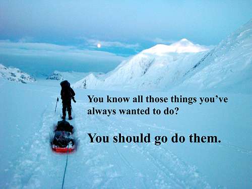
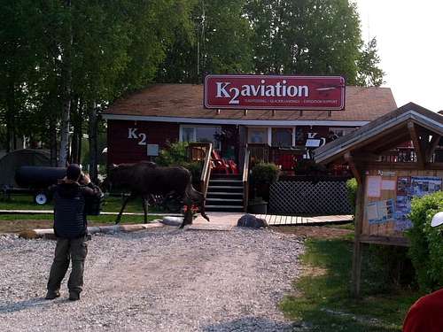
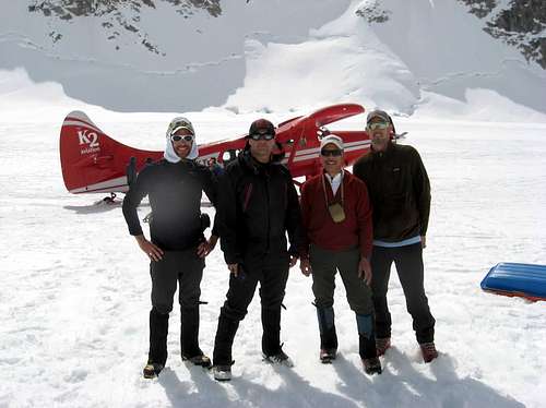
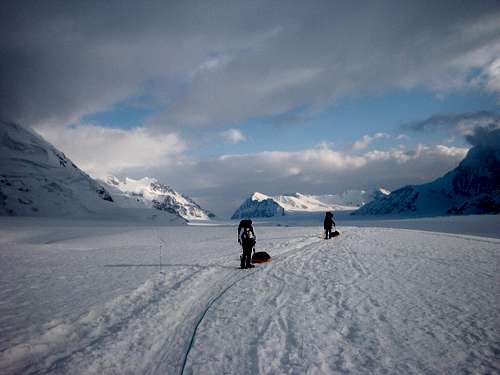
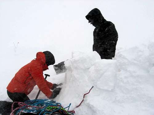
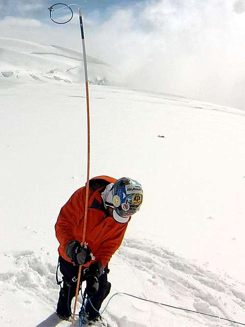
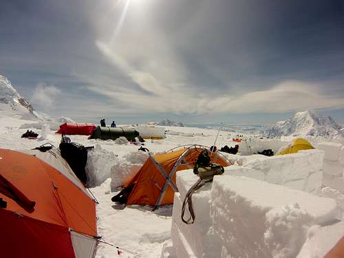
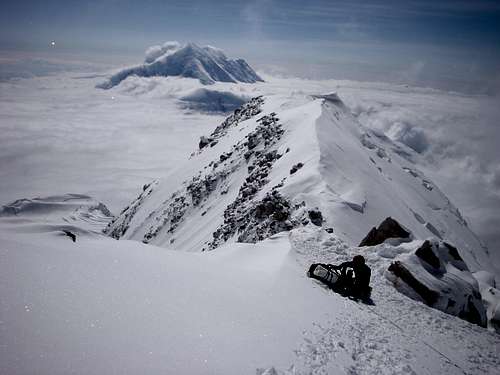
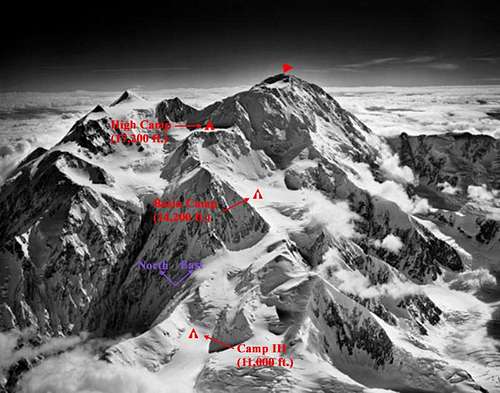
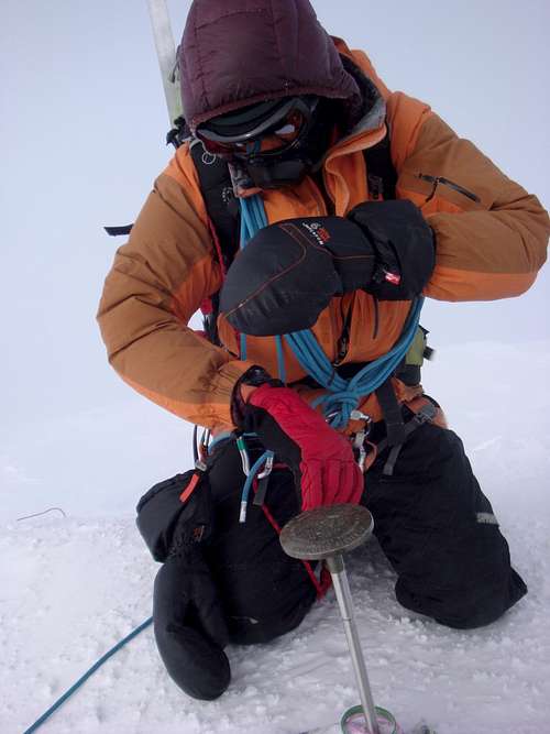
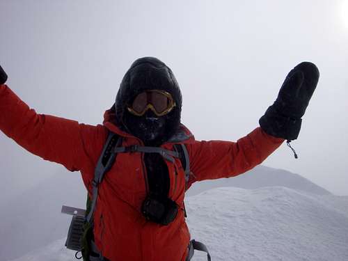
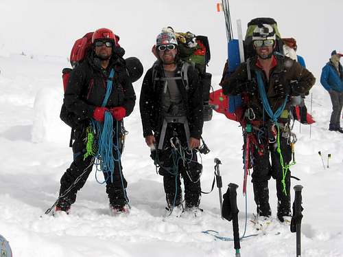
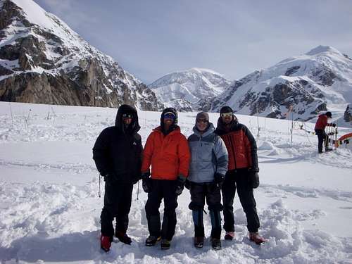
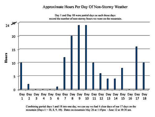
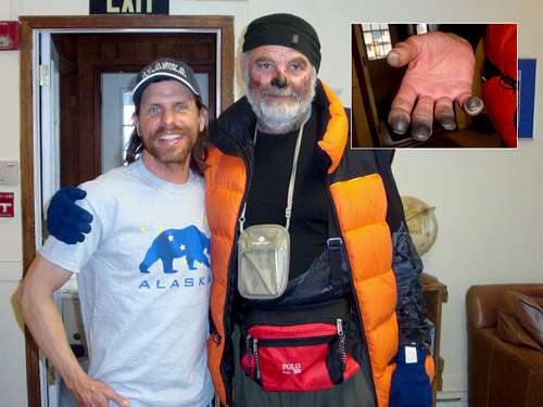
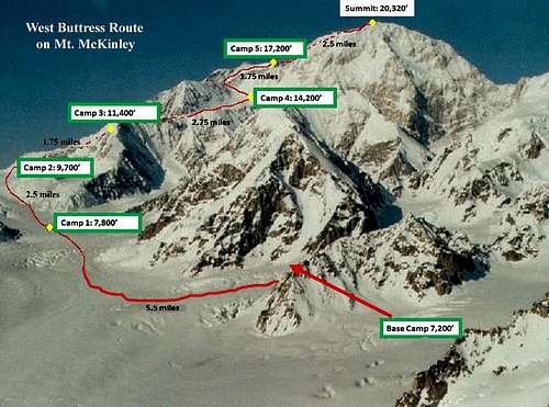
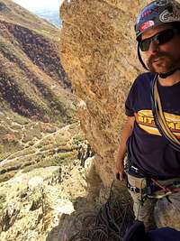


Comments
Post a Comment