Overview
After a few climbs in the Adirondacks and Catskills in previous weeks, I was in full-gear hiking mode and ready to tackle something bigger. Having never stepped foot in the Dix Range Wilderness, Dix Mountain seemed like a prime candidate. As I started to do some research on the other peaks in the area, I ran across
Backpacker Magazine’s
Five Mountain Loop hike which immediately piqued my interest. However, I really wanted to keep my hike to a day and their recommended three day outing starting and ending at Rt-73 just wasn’t my cup of tea. So instead, I looked into an alternate way of doing the traverse starting from the Elk Lake trailhead to the south instead. Information on this route was seemingly hard to come by, with only a few pages on the internet making mention of this loop, and no Route page or Trip Reports on SP to my knowledge. However, the climber’s logs for all five high peaks in the Dix Range clearly show that this loop is popular among SP hikers, and so I thought that undertaking the hike and adding some documentation might be to everyone’s benefit.
So that’s the background... now for the hike itself. The Dix Range Traverse from Elk Lake is a total of 16 or 17 miles with about 5000 ft of elevation gain along the way. Not an easy hike by any means, but it certainly doesn’t rival the much more popular Great Range Traverse which has anywhere from 8000 to 10000 ft of elevation gain. It’s doable in a single day if you’re in good shape, but for those who prefer a slower pace, it can easily be turned into a multi-day trip with several convenient lean-tos off the Elk Lake-Dix Trail as well as a bivouac site in the col between Pough (the subpeak between South Dix and Hough) and Hough at about 3900 ft.
When doing the Dix Range Traverse from Elk Lake, there is a fundamental decision on whether you want to do it counter-clockwise or clockwise. For some, descending the Macomb slide at the end of a long day may not sound like a friendly proposition. For others, having to descend the 6 or 7 miles from the summit of Dix at the end of the day may sound like a worse proposition. However, I found myself in the former group and thus decided to ascend the Macomb slide early in the day and then take the herd paths going to South Dix, East Dix, back to South Dix, Hough, and finally up to Dix Mountain before finally descending from the Beckhorn or through Hunters pass.
Elk Lake to Macomb
Start Time: 7:30am
Finish Time: 9:45am
Section Mileage: 4.1 mi
Section Ascent: 2365 ft
Knowing that I had a long day ahead of me, I wanted to get a good early start in case the hike lasted late into the evening. I woke up at 5am sharp and was out the door by 5:30am. From my home in the Capital district to the Elk Lake trailhead took slightly less than two hours, and I enjoyed driving through some low-laying clouds that made me feel more like I was in an airplane than in a car. Arriving at the trailhead at 7:15am, I pounded down some food and gatorade and was ready to hit the trail by 7:30am. There was one guy who went on the Elk Lake-Dix trail a few minutes a head of me, and within the first half-mile I caught up to him. It turned out he too was doing a similar route as myself, but intended on turning around after reaching East Dix rather than proceeding up to Dix, so we decided to pair up for the time being.
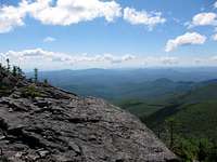
The first 2.3 miles to the Slide Brook lean-to was practically flat, gaining very little elevation, but the going was slowed down by the fact that the trail was really more of a stream/mud path than a dirt trail. However, having some company kept my mind off the fact that my feet were wet within 10 minutes of stepping on the trail. After crossing the Slide Brook lean-to, we beared right to pass a campsite and continued on the easy-to-follow path leading up to the base on the Macomb slide. The mile or so from the Slide Brook lean-to to the slide gets gradually steeper as you go along. Shortly before we reached the slide, my adopted companion was getting a bit winded and encouraged me to continue on at my own pace so I wouldn’t jeopardize my chances of finishes the traverse on time. Agreeing with him, I pressed on at a faster pace. To reach the slide, the path abruptly turns to the right to cross the brook and shortly thereafter leaves you at the base of the slide. All my readings on the Macomb slide told me to stay to the left initially, and then pass to the right as I neared the boulder near the top. However, there had evidently been significant erosion on the left part of the slide in the last year, so I veered right instead and would encourage others to do the same. Upon reaching the boulder, one can pass it to the left or right- it doesn’t matter a whole lot. Either way, the slide naturally tunnels you back on to the herd path above. While climbing and upon reaching the top of the slide, I was treated to my first great views of the day, aided by the clear sunny weather that I had purposely waited for to make this trip. After exiting the slide, the herd path continues to climb up to the summit of Macomb where fantastic views to the West are to be had at the rock outcropping.
![Macomb Slide]() View above Macomb Slide View above Macomb Slide |
![View from Macomb]() View from Macomb View from Macomb |
Macomb to South Dix
Finish Time: 10:25am
Section Mileage: 0.7 mi
Section Descent: 625 ft
Section Ascent: 280 ft
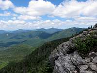
After stopping briefly to grab a bite to eat atop Macomb, I continued my way on the herd path that leads down to South Dix. After being a little unsure if I was on the right path (it seemed to be going to the left too much), I stopped briefly to check my map and compass and confirmed that I was indeed going in the correct direction despite my own doubts. Sure enough, after a short and not-too-arduous descent, I reached the bottom of the col between Macomb and South Dix and saw the open rocks leading up to the summit of South Dix. The herd path coming up the bare rocks becomes less well defined with no cairns, but I never had any problem figuring out where the path continued after reaching the end of a rock section. Nice views continue along the open rocks, but honestly, of the five peaks in the traverse, I would rank them at the bottom. After the open rocks, the herd path continues on through forested area where it passes by the actual summit rather anticlimactically. I stopped briefly to get some pictures and reenergize with some electrolytes and continued onward. Going from the summit of Macomb to the summit of South Dix only took about 35 minutes.
![View from South Dix]() Open rocks below South Dix summit Open rocks below South Dix summit |
South Dix to East Dix
Finish Time: 11:15am
Section Mileage: 1.1 mi
Section Descent: 360 ft
Section Ascent: 312 ft
From South Dix, one cannot actually see the summit of East Dix, but they’re only a short 1.1 miles apart. Shortly past the summit of South Dix, one encounters a junction marked by a small pile of rocks (I wouldn’t even call them a cairn). To the left lies the herd path leading to Hough Peak, and to the right lies the path leading to East Dix. I continued to the right and maintained a brisk pace. Again, I found the herd path very easy to follow and never wondered if I was on the right track. The descent and ascent from South to East Dix is probably the most gentle of the whole traverse, allowing me to make good time to the summit of East Dix. Upon reaching the summit of East Dix, I was treated with gorgeous views in every direction, including a nice view of the whole Dix Range that provided perspective on what I had accomplished thus far and what lay ahead. The mile from South to East Dix took me about 45 minutes.
At the summit of East Dix, I ran into another hiker for only the second time that day. He too, like the gentleman I had joined with before, told me he intended on doing Macomb, South Dix, and East Dix but when I ran into him later on the path to Hough, it turned out he was feeling good and decided to do all of them. I spent a little more time at the top of East Dix than the previous two summits to take in the nice views and eat something a little more substantial. It was about 11:15am, and considering I had been up since 5am, I decided it was a good time for lunch. I was feeling great having accomplished three peaks in under four hours and my body was holding up pretty well. Nevertheless, an imminent attack by flies of various sorts and sizes squandered my euphoria, abruptly ended my lunch break, and forced me to move on.
![View from East Dix]() View from East Dix View from East Dix |
![South Dix, Pough, Hough, Dix]() Looking at Dix Range Looking at Dix Range |
East Dix to Hough
Finish Time: 12:30pm
Section Mileage: 2.0 mi
Section Descent: 572 ft
Section Ascent: 960 ft
The herd path leading back to South Dix seemed just as easy on the way back as it did on the way there, and I made even better time returning to South Dix. Knowing there were no great views near the summit, when I reached the herd path junction I pressed on to begin the trek up to Hough passing over its subpeak which is known as Pough. This section of the trail was again very easy to follow and had excellent views along the way thanks to numerous outcroppings. I found myself wanting to stop every five minutes to take pictures, but I did my best to refrain from the urge and just wait until I got the the summit. At 12:30pm, I reached the summit of Hough Peak and again took a moment to relax, fatten up on some trail mix, and enjoy the wonderful views and especially the vantage point of Dix Mountain looming in front of me.
Evidently, Hough Peak seems to be infested with a sizable population of hornets and other nasty bugs. While the hornets didn’t seem to have a strong desire to come sting me, the other bugs were relentless in buzzing all around my face, so I decided enough was enough and that I would just finish the final push to the Beckhorn to take a real break.
![View from Hough]() View from Hough Peak View from Hough Peak |
Hough to Dix
Finish Time: 1:30pm
Section Mileage: 1.3 mi
Section Descent: 380 ft
Section Ascent: 837 ft
Having already completed close to 4000 ft in ascent in the day so far, I wasn’t too excited at the propsect of another 800 ft climb. Nevertheless, it was the only thing standing between me and my fifth high peak of the day, so with adrenaline pumping I began the last stretch to the Beckhorn on Dix. The herd path drops a few hundred feet into the col between Hough and Dix and then begins climbing up Dix at a moderate grade. As one gets closer to the top, the grade gets progressively steeper and in fact the final tenth of a mile or so seemed to be even steeper than the Macomb slide I had climbed earlier in the day (a quick glance at a topographical map seems to corroborate this observation). 50 minutes after leaving Hough, I arrived at the Beckhorn and was greeted by breathtaking scenery in every which direction. To my surprise, I found myself alone on the top of Dix Mountain, the sixth highest summit in the state of New York (ok, it
was a Monday afternoon, but still I figured at least
a few people would play hooky to go climbing in the high peaks).
Originally intending on stopping at the Beckhorn for a break, upon arrival I couldn’t resist running over to the actual summit. The short col between them takes about ten minutes to get across, and at 1:30pm, I reached the summit Dix and stopped for a well-deserved break. Shortly after arriving, two females hikers joined me on the summit having come up the route from Rt-73.
It was interesting to see the 1873 benchmark on the summit and reflect on how much the world has changed since then. Yet the mountain on which I stood was more-or-less exactly as it was in 1873, inspiring generations of climbers to endure the physical challenge to reach its summit.
![Looking back at Dix Range]() Looking back at Dix Range Looking back at Dix Range |
![Great Range]() Great Range in the distance Great Range in the distance |
![The Beckhorn]() The Beckhorn The Beckhorn |
![View from Dix Summit]() Dix Mountain summit views Dix Mountain summit views |
Dix to Elk Lake
Finish Time: 5:00pm
Section Mileage: 7.3 mi
Total Mileage: 16.5 mi
Total Time: 9.5 hours
Total Ascent: ~5000 ft
Having made it to all five peaks with no problem and at a pace quicker than I was anticipating, I was in high spirits before starting my descent back to Elk Lake. One of the gentlemen I ran into earlier in the day said that he heard the trail descending from the Beckhorn was steep and rocky, so I decided to descent via Hunters Pass instead thinking that it might offer a less grueling descent. He may have been correct in that statement, but even the less-steep Hunters Pass quickly withered away my enthusiasm and provided no relief to my knees which were already starting to hurt at the beginning of the descent. The first three miles on the way down was agonizing, both mentally and physically. By the time I had reached flatter ground, my back, knees, shoulders, and hips were all hurting to various degrees. The final four miles on the Elk Lake-Dix Trail should have been easy, but it was covered in mud and streams in so many places that I couldn’t just race back to the trailhead as I would have liked to. I finally reached the trailhead at 5pm on the dot with plenty of daylight to spare and made it back home in time for dinner. All in all, not a bad day!
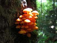
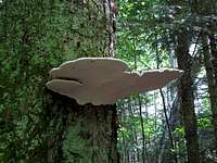
One redeeming aspect of the long and grueling hike back to Elk Lake was the variety of flora and fauna which I encountered along the way, some of which are shown in the photos below.
![Eastern Tiger Swallowtail]() Eastern Tiger Swallowtail Eastern Tiger Swallowtail |
![Dragonfly near Dix Pond]() Friendly dragonfly Friendly dragonfly |
![Bumpy Frog]() Bumpy frog Bumpy frog |
![Orange Mushrooms]() Orange Tree Mushrooms Orange Tree Mushrooms |
![Enormous mushroom]() Enormous fungus Enormous fungus |
![More mushrooms...]() More interesting mushrooms More interesting mushrooms |


Comments
Post a Comment