Preface
I had been anticipating traversing the "trailless" Dix Range in the Adirondacks since back in the winter for two reasons: (1) A good hiking challenge to look forward to in better weather, and (2) really needing to get back to completing my ADK 46er list. Initially detailed information was scant. The ADK High Peaks guide mentions herd paths but there was really little information of how off the beaten track this was going to be. Closer to the intended date I found a couple of on-line trip reports indicating the herd paths were really in very good shape. Lillian lamented "You're not as young as you used to be" and was fearful of my going solo. Mere mention of this trip made most of my friends squeamish, so I was extremely pleased when two weeks out RD Jim told me he'd like to come along for the ride.
RD Jim is the legendary (at least in small circles) founder and ten-time director of the Damn Wakely Dam Ultra, a 32.6-mile unsupported trail run through the West Canada Lakes Wilderness Area. Yes, he was my one friend crazy enough to get excited about doing this adventure with me. We both now eagerly anticipated the morning of July 5th.
The Hike
I left the Cedar River at the crack of dawn. After a well-planned rendezvous with Jim, we were departing the Elk Lake trailhead at 6:15 AM. We would traverse five mountains, one twice, four officially "trailless", and all above 4,000-feet elevation. We knew we were in for a quiet day ( a good thing) when there was only one other car in the trailhead parking lot upon our departure. This has been my repeated experience that the hiking crowds head to Keene Valley / St. Huberts / North Elba and leave the southern approaches to the high peaks generally alone. It was a beautiful clear day with very light winds. The temperature was in the upper 50s F.
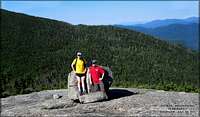
The hiking trail into Slide Brook was essentially level and we made good time. Just after the brook we turned right at a cairn, through a campsite, and started to gradually ascend Macomb Mtn., paralleling the creek. The trail was quite good and we got higher on the mountain before reaching the slide than I anticipated. Just before the slide you cross the brook. Gas up! This is the last running water we saw for many hours. The bottom of the slide was a bit loose but overall it was an easy climb, quicker than anticipated, and never more than an easy Class 2 scramble. We probably were up the slide in 30 minutes and back into the woods. We quickly reached the summit, which had spectacular views.
![Macomb Slide]() Macomb Slide
Macomb Slide![Macomb Summit]() Macomb Summit
Macomb Summit
We headed north to South Dix. The trail was a bit overgrown in spots but always easy to follow. The open ledges south of the summit provided nice views. While relaxing on the rocks we heard the "ghost hikers of South Dix". We both swore we heard voices, and expected to see humans any minute. We didn't see a soul until the summit of Dix Mountain, over three hours later.
![South Dix]() South Dix
South Dix
The actual summit of South Dix is heavily wooded. We crossed the summit and reached a trail junction with a cairn. Right led to East Dix. Left led to Hough (pronounced "Huff") Peak. We turned right. This was a fairly long, fairly level ridge traverse. I was surprised by much of the trail throughout in that previous descriptions led me to expect a more open ridge walk with continuous views. We got a good view from each summit, but other than the ridge near Hough Peak, most of the time we were in the woods. No worries, it was all fun!
East Dix had a great open summit and we paused for lunch. This sets out from the rest of the range. I shot a very amateurish video, which may be viewed
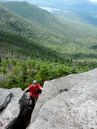
here . We then re-traced our steps back to South Dix. At the cairn we turned right to Hough. I think it was the col between the two that was the only time all day we paused to check the compass, well, technically, Jim's GPS. We assured ourselves we were on the right trail and continued to Hough Peak. This is a lovely, relatively open mountain with regular open ledges and views. We had great views up towards the Beckhorn on Dix Mountain. Man, did that look steep from down here!
![South View From East Dix]() South View From East Dix
South View From East Dix![Climbing Hough Peak]() Climbing Hough
Climbing Hough![Beckhorn from Hough]() The Beckhorn From Hough
The Beckhorn From Hough
It was steep. The climb up the Beckhorn was the most technically demanding stretch of the trip. There was one interesting chimney we had to angle up that was definitely a Class 3 move. It was fun with a day pack. I wouldn't have wanted to try it with a full pack. We crested the Beckhorn, saw trail blazes, and immediately found civilization. It was only another 0.2 miles of fairly level ground to the actual summit of Dix. There were probably 40 people on top. All had approached from the North side. There were some nice folks up there, but the noise of a dozen kids doing high school cheers was a bit much. After photo ops. and rest we headed down the now marked Beckhorn Trail.
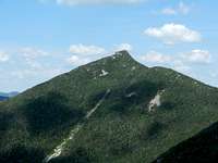
![Dix Range From Dix Mtn.]() L to R, East Dix, Hough, South Dix, Macomb from Dix
L to R, East Dix, Hough, South Dix, Macomb from Dix![Dix Summit]() Team Wakely on Dix Summit
Team Wakely on Dix Summit
The first 1.5 miles or so of trail were quite steep, especially now on somewhat tired legs.
We were grateful to reach the first running water after about an hour of steady downhill travel. Another bit brought us to the trail junction with the Hunter's Pass Trail and level ground. From here it was a mere 4.3 miles back to the car. Didn't that feel like it took a long time! We paused at Lillian Brook for a photo op. with the sign. The temperature was in the upper 70s F and we were glad we still weren't climbing. Eventually we sauntered back to the parking lot. We saw some stowed packs at the Slide Brook lean-to, but other than the Dix summit didn't see a soul the whole day.
Upon return to the cars, we celebrated with a cold beer, and Jim stated "That wasn't so bad". I replied "Yes, that's because most of our family and friends think we are both insane". OK, 32 high peaks in the log book and 14 to go. Some young Canadians came in backpacking from the other direction and we shared a beer with them. Soon we said our goodbyes and pledged to get together for another adventure soon. I was back to the Cedar River in time for dinner!
Numbers And Stuff
Waypoint Distance Gain Summit Segment Time Total Time
miles feet feet
Elk Lake
Slide Brook 2.3 300 0:51 0:51
Macomb Mtn. 2.0 2100 4405 1:23 2:15
South Dix 1.0 300 4060 0:50 3:05
East Dix 1.6 320 4012 0:47 3:52
South Dix 1.6 360 4060 0:56 4:49
Hough Peak 1.1 650 4400 0:43 5:32
Dix Mtn. 1.4 825 4857 1:12 6:45
Trail Jct. 2.3 0 1:50 8:35
Elk Lake 4.3 200 1:51 10:26
Total 17.6 5055
Note times include leisurely periods enjoying summit views! We probably spent 1.5 hours on summits, so travel time was about 9 hours. Jim's GPS indicated 15.3 miles. I'm still old school and did this table with a topo. map and ruler. So, topo. map or GPS? You can decide!
Acknowledgement
GPS Google Earth track (way cool) and two of attached photos by RD Jim.


Comments
Post a Comment