
|
|
Mountain/Rock |
|---|---|
|
|
19.39711°N / 98.88991°E |
|
|
7300 ft / 2225 m |
|
|
Overview
Doi Chiang Dao (ดอยเชียงดาว), also referred to as Doi Luang Chiang Dao (ดอยหลวงเชียงดาว), is the third highest peak in Thailand and hands-down the peak to climb as a short trek on any trip to northern Thailand (note the link for access to mountaingazelle's excellent page overviewing the region). Although Doi Inthanon is far more popular for being the highest point in the country (and a drive up Doi Inthanon is well worth a trip both for the summit and the nearby waterfalls), Doi Chiang Dao offers a much more authentic experience and has spectacular views of surrounding peaks and terrain that are largely lacking on its larger neighbor to the southwest.
Doi Chiang Dao is an incredible 230-250 million year old limestone massif in the Daen Lao Range and rises abruptly and impressively from the plains below where Chiang Dao town is located. The town and subsequently the peak translate to the City of Stars, a reference to the high peaks and elevations in the immediate area. The town is located in far northern Thailand approximately 65 kilometers north of the center of Chiang Mai and less than 50 kilometers from the Myanmar boarder to the north.
The peak is most commonly done as an overnight trip by both foreigners and locals though for fit individuals a day trip is reasonable and easily accomplished. Doi Chiang Dao is very popular for its wealth of wildlife and nature as it hosts many flowers visible throughout the trek and is a popular birding destination for visitors worldwide.
Note that during my first visit (in February 2012) there were a large number of fires burning in fields in the immediate area that affected the fantastic views. This didn’t take away from our pleasure with having done the trek, however, but it the haze did appear in some of the photos I have uploaded here. Don’t let this potential discourage you from planning a hike here if you are so inclined, as it remained an outstanding and rewarding trip nonetheless. Conditions were a bit better during my second trip to the area in January 2013.

Getting There

Road Map

Route Map
Renting a car in Chiang Mai and driving to Chiang Dao is a simple option, though public transportation is readily available and costs next to nothing. Taxis are also available and about ฿1000 each way. Taking a motorbike is possible but less common due to the distance from Chiang Mai (if taking public transport to Chiang Dao, a motorbike rental upon arrival is the recommended option for getting around locally until your departure).
By motorbike or car:
The drive from Chiang Mai to Chiang Dao begins at the northern end of the old city and continues straightforwardly approximately 65 kilometers north on Route 107 towards Mae Rim and Mae Taeng. After about 30 kilometers continue straight to stay on Route 107 as Route 1095 bears left towards Pai. As you approach Chiang Dao turn right where signs direct you towards the small city center. The last portion of the drive is quite curvy but also very scenic.
By bus or songthaew:
Public buses run from the Chang Pheuak terminal in Chiang Mai to Chiang Dao approximately every 30 minutes during the day and cost as little as ฿40 and taking only about 1 ½ hours. Picking up a songthaew along Route 107 is also an option.
From the city center in Chiang Dao turn left (west) just after the Chiang Dao Inn towards Chiang Dao Cave and the majority of the available accommodations. After about 5 km pass Chiang Dao Cave and continue approximately 12 kilometers past the cave to the Pang Wua trailhead area on your left (passing the checkpoint gate along the way).
The road to the trailhead is in good condition, and any car or motorbike should not have any problems.
Route Description
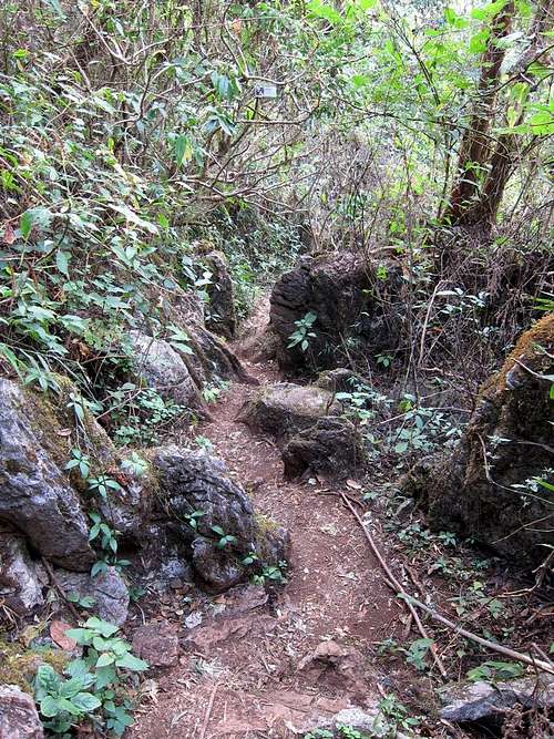
Forest en route to Doi Chiang Dao
Though there are a couple of options for accessing Chiang Dao, the description here covers the route from the Pang Wua trailhead to the north. The route is simple to follow with a good but sometimes rough trail all the way to the summit. Note that there is generally no water available en route and consequently you will need to plan to bring a full supply with you. Good shoes are also recommended as is bug spray if it is near or shortly after the wet season.
Trip statistics from Pang Wua Trailhead:
7.5 kilometers one-way, 1100 meters elevation gain out with negligible gain on the return
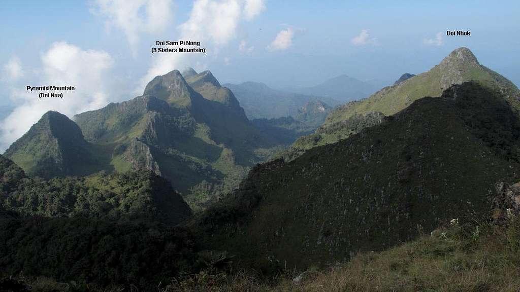
The trailhead begins at a saddle at 1100 meters elevation and passes through forest gently rising 100 meters for a short distance before soon climbing very steeply (this portion would be difficult if wet or muddy) to a saddle at nearly 1500 meters that marks the northern gateway to the fantastic Ao Salung Valley. As you enter the valley breathtaking monoliths of limestone rise to dramatic peaks all around you. The peaks of Doi Sam Pi Nong appear as an imposing site forming the southern wall of the valley across from Doi Nhok to the north (the lower west ridge of Doi Nhok is visible to your left as you enter the valley).
Continue south and then east up the valley as the trail winds its way in and out of the forest to impressive views in every direction. Pass the junction to the southern route on your right and continue to the upper end of Ao Salung. Though a couple of possible camping spots are passed along the way the final (and by far the most common) camping area is passed a short distance from the base of the final climb ahead and to the left. The trails through the camping area can be a bit confusing, just continue along the most obvious route another 20-30 minutes to the peak. If the weather cooperates powerful views spread out in a 360 degree panorama below you.
Red Tape
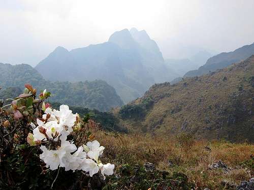
Flora on Doi Chiang Dao's Summit
Officially a guide is necessary to hike or visit the Doi Chiang Dao area, which can take several days to arrange. There are, however… how should I put this… other options available.
As you approach the trailhead the park fee must be paid at the checkpoint approximately 3-4 kilometers past the Chiang Dao Cave. Other requirements such as the prerequisite guide mentioned above will also be verified… usually. Park fees run ฿200/person for foreigners and ฿20/person for Thais.
When to Visit
There are three seasons in Thailand, and northern Thailand is best visited during the cool season (though it is more crowded during this time). This season lasts from November through February with comfortable temperatures during the day and cool (and sometimes even cold) temperatures at night. Always be prepared for especially cool and windy temperatures on and near the summit of Doi Chiang Dao.
The hot season lasts from March to May, and not a bad alternative time to visit. This is especially true if you can time your visit to be around April 15 when the entire country celebrates Songkran, the Thai New Year festival. During Songkran the streets are filled water fights and participants rubbing scented chalk on fellow partiers’ faces. I highly recommended the experience.
The rainy season lasts from May until November with high humidity and daily downpours (though they are often brief). If you are planning to do any trekking or visit the summit of Chiang Dao then this season is best avoided.
 |
 |
 |
 |
 |
 |
Lodging
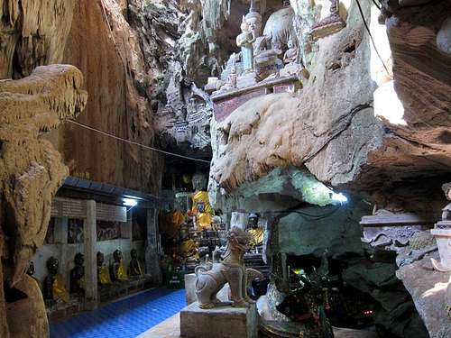
Buddha Images Inside the Entrance of Chiang Dao Cave
As mentioned Doi Chiang Dao is a popular overnight destination for both locals and foreigners, though day trips are entirely feasible. When tackling the peak as an overnight trip, the final camping spot at the far eastern end of Ao Salung Valley is by far the most popular. Camping below the summit allows visitors to visit the summit for both the sunset the day of arrival and see the mist clear as the sun rises the following morning.
For day trips there are several lodging options available in Chiang Dao and many great bungalows and rooms available on the drive from town to the trailhead as you pass the Chiang Dao Cave area. During our visit we stayed at Malee’s Nature Lovers Bungalows, and I would recommend it to future visitors. The bungalows are in a lovely setting, and the owners are very friendly and helpful.