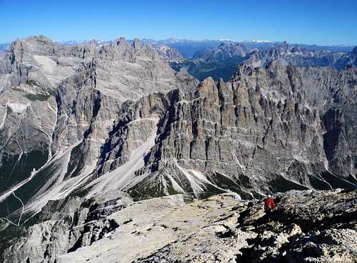
“Come, have a close look at this wonder, without a doubt one of the most beautiful, powerful and astonishing gifts from our planet… Are they rocks or clouds? Are they true or maybe a dream?” - Dino Buzzati, "Le Montagne di Vetro", 1956
Also called "Pale Mountains" in reason of the impressive white bright colour which they assume under the moonlight, the Dolomites show a landscape marked by distinctive and unique characters, with an extraordinary aesthetic value: their beauty comes from a wide variety of spectacular steep rock formations, such as needles, massive towers, spires, huge walls, interrupted by the horizontal shapes, like ledges, karst tablelands and crags, rising suddenly from vaste screes and gentle hills. The green bottom valleys clash surprisingly with the awesome vertical rise of the mighty walls and peaks. Under the geological and geo-morphological aspects, the Dolomites are regarded as a Property of global value, being an exceptional example representing the history of the transformation of the primary carbonatic platform into an alpine range. The Dolomites scenery is regarded as the archetype of the various "Dolomites' landscapes" existing all around the world.
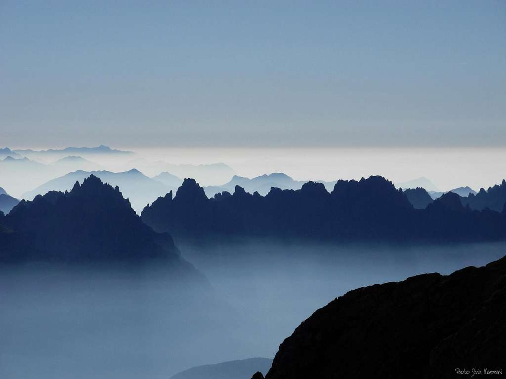
Blue ridges
The origins of the Dolomites
History tells us that the Dolomites have not always been peaks. The building of the Dolomites started about 280 million of years ago, when a mountain range lying nearby the ocean began to sink. At the end the area became a warm vastness of water. About 240 million years ago, some organisms began to build reefs, atolls and small islands. The next era was characterized by volcanism; for a long time great volcanic eruptions affected the region, so that lava and volcanic rocks buried and changed the existing reefs. When volcanoes stopped their activity, then eroded, their rocks started to settle in the sea and the organisms could restart to build coral reefs. 228 million years ago the region was again occupied by the sea and this led to the appearance of carbonate deposits. In this era dinosaurs started to inhabit this plain, testified by the recent finding of some footprints. About 210-190 million years ago, between the Triassic and the Lower Jurassic, there was a new phase of sinking which led to the depositing of new limestone. Progressively, between the Upper Jurassic and the Cretaceous (about 170 and 65 million years ago), there was a massive depositing of fine limestone and marl sediments. At the end of the Cretaceous, due to the clash between Europe and Africa, this sediments began to emerge so to form a mountain range: the Dolomites.
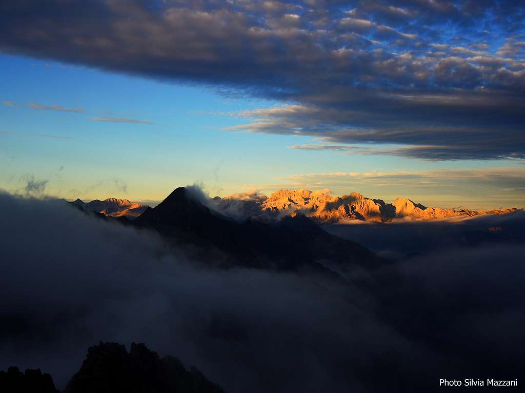
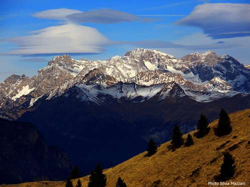
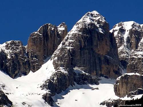
Brenta Dolomites at sundown
The discovery of the Dolomites
The "discovery" of the Dolomites can be dated back to 1789, when the French geologist de Dolomieu, traveling through South Tyrol, sampled a carbonate rock which reacted to the hydrochloric acid in a different way from limestone. Attracted by this observation, he sent several samples to the Swiss mineralogist Nicolas Theodore de Saussure, who analyzed and described them as carbonates of calcium and magnesium. To pay homage to its discoverer, the new mineral was called "Dolomite", a term from which the Dolomites derive their present name.
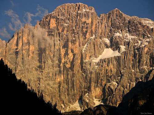
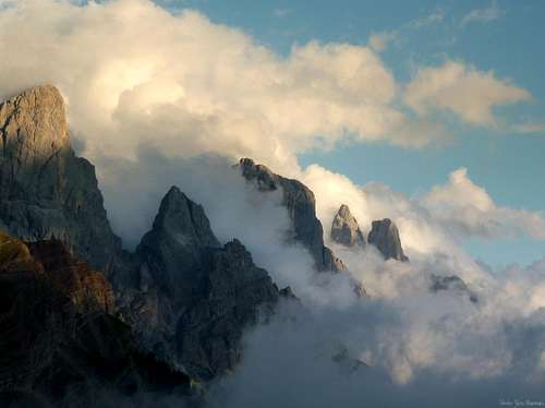
Civetta, the hanging glacier at sunsetPelmo and Pelmetto dominate the Alpe di Mondeval
Dolomites acknowledged as UNESCO World Heritage Site
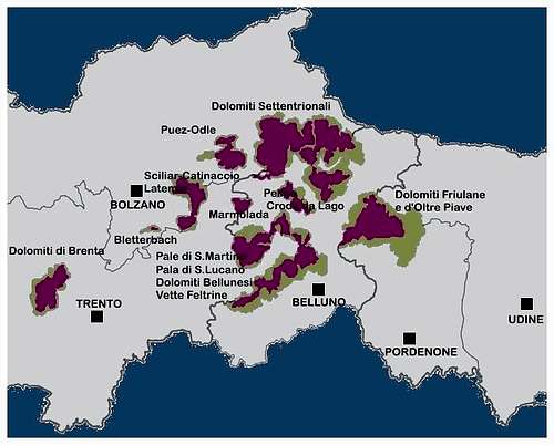
On 2009, June 26th nine rocky systems belonging to the Dolomites were acknowledged as an UNESCO World Heritage Site by the Committee gathered in Seville. The site of the Dolomites comprises several mountain ranges in the Northern Italian Alps and features some of the most beautiful mountain landscapes in the world. The acknowledgment came after a very long and complex examination, mainly in reason of the territorial fragmentariness of the nine areas, ruled by different bodies, and was the result of the engagement supported by different Mountaineering Associations and Public Administrations, which started to work around the project since 1987 and overcame several obstacles. These nine systems, named “Heart Areas”, have not indeed a territorial contiguity and not the same administration; five different provinces - Trento, Bolzano, Belluno, Pordenone and Udine - rule the territories. The problem was solved in the late years by entrusting the government to a unique subject, the “Fondazione Dolomiti Dolomiten Dolomites Dolomitis UNESCO”, having its seat in Cortina d’Ampezzo (BL).
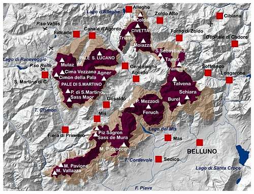
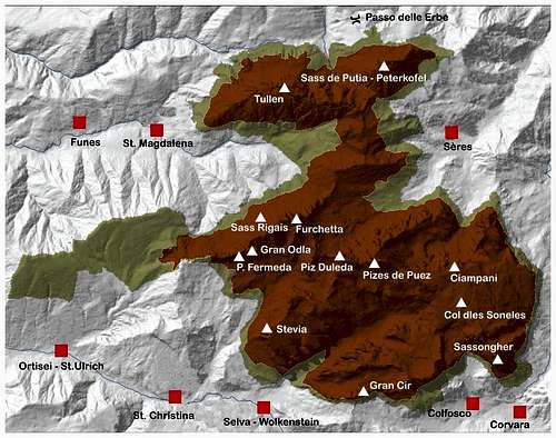
Nine zones of outstanding universal value: the nine “ Heart Areas”
Dolomites Unesco Site general map
The UNESCO site covers 141.903 hectares, almost entirely uninhabited, divided into nine "Heart Areas", including 19 mountain-chains and 220 summits, amongst which 42 exceeding the altitude of 3100 meters and 40 rising between 3100 and 2950 meters. Each "Heart Area" is surrounded by a Buffer Zone, a zone created with the purpose of protecting "the Property", covering a global surface of further 89.266 hectares.
The nine Systems:
- Pelmo e Croda da Lago - Marmolada - Pale di San Martino, Pale di San Lucano, Dolomiti Bellunesi, Vette Feltrine - Dolomiti Friulane e d’Oltre Piave - Dolomiti Settentrionali (Northern Dolomites) - Puez-Odle - Sciliar-Catinaccio e Latemar - Rio delle Foglie - Bletterbach - Dolomiti di Brenta (Brenta Dolomites)
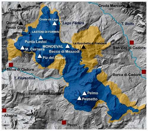
Pelmo and Croda da Lago
Pelmo and Croda da Lago map
Pelmo and Croda da Lago
Surface: 4344 hectares Buffer zone: 2427 Coordinates: N46 26 52.00 E12 6 49.00 Provinces: Belluno Main peaks: Pelmo m. 3168, Pelmetto m. 2990, Croda da Lago m. 2701, Lastoni di Formin m. 2657, Monte Cernera m. 2657, Becco di Mezzodì m. 2603
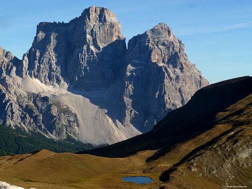
This system was the first one to be acknowledged, not only in reason of its scenic beauty, but also for its scientific and geological value. Its rocks are the best witness of a time's interval enclosing about 100 million years. Monte Cernera shows clearly the signs of the primary Triassic archipelago which occupied the area, while Lastoni di Formin and Rocchette are the witness of the history of the islands, built by sea-organisms and the successive filling of the sea-sounds between the islands. Moreover, the area is excellent in reason of two important discoveries: the Mesolithic site (Man of Mondeval) on the Mondeval basin, located below Lastoni di Formin, and the dinosaur footprints, detected in Pelmo and Croda da Lago groups. It belongs entirely to the Province of Belluno and it is bounded by the Boite Valley to the East, the Zoldo Valley and the Fiorentina Valley to the South, the Costeana Valley and Codalonga Valley to the North. The highest peak is Pelmo, one of the most scenic and celebrated mountain of the Dolomites, also remembered for being the first one to be climbed in 1857 by the English pioneer John Ball. Besides Pelmo and Pelmetto, the system is composed by different distinct groups, as the secluded Croda da Lago, the Lastoni di Formin, the Cernera Group.
The "Gothic Cathedral" of Croda da Lago from Lastoni di Formin
Antelao and Becco di Mezzodì
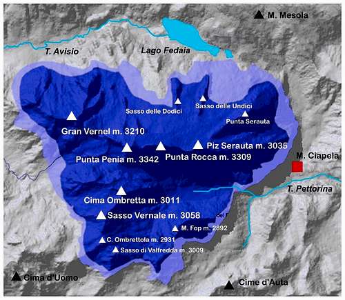
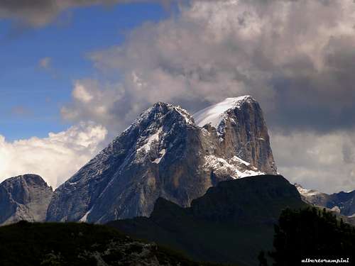
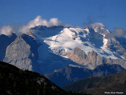
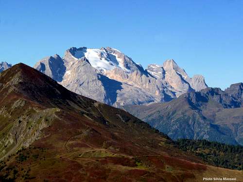
Marmolada
Marmolada map
Marmolada
Surface: 2208 hectares Buffer Zone: 2427 ha Coordinates: N46 25 54.00 E11 51 23.00 Provinces: Belluno, Trento Main peaks: Punta Penia m. 3342, Punta Rocca m. 3309, Punta Serauta m. 3218, Gran Vernel m. 3210, Piccolo Vernel m. 3098, Sasso Vernale m. 3054
This secluded area, shared between Belluno and Trento provinces, is dominated by Punta Penia m. 3342, the highest summit of Marmolada, and of the whole Dolomites, and it is bounded to the West by Fassa Valley and to the East by Cordevole Valley. Unlike the rest of the Dolomites, which are composed of “dolomite”, this massif is composed of white and compact limestone. Marmolada, also called "The Queen of the Dolomites", shows an impressive contrast between the sparkling and gentle-sloping Northern side, covered by glaciers, and the high and stunning rocky South Face, showing a very white limestone.
Marmolada and Gran Vernèl
Marmolada Northern glacier
Marmolada in Fall
Pale di San Martino, Pale di San Lucano, Dolomiti Bellunesi, Vette Feltrine
Pale di S. Martino, Pale di S. Lucano, Dolomiti Bellunesi, Vette Feltrine map
Pale di San Martino, Pale di San Lucano, Dolomiti Bellunesi, Vette Feltrine
Surface: 31666 hectares Buffer zone: 23668 ha Coordinates: N46 14 51.00 E11 59 39.00 Provinces: Belluno, Trento Parks and Nature Reserves: Dolomiti Bellunesi National Park, Paneveggio–Pale di San Martino Natural Park Main peaks: Civetta m. 3220, Cima della Vezzana m. 3192, Cimon della Pala m. 3129, Pala di San Martino m. 2982, Cima della Fradusta m. 2939, Mulaz m. 2906, Moiazza m. 2878, Agner m. 2872, Sass Maor m. 2814, Schiara m. 2565, Torre Trieste m. 2458, Burel m. 2281
A wide system of great value, showing an extraordinary variety of geological phenomena and all the typical characteristics of the Dolomites landscape, as high and vertical cliffs, wide mantles of detritus, flat structural components, breaking off the steepness of the walls. Moreover, the system shows one of the most complete stratigraphic series of the whole Dolomites, from the Early Paleozoic to the Cretaceous. There are several unspoiled areas and some Nature Reserves, besides different mountain groups, as Civetta, Pale di San Martino, Pale di San Lucano, Monti del Sole and Moiazza, enumerating some of the most important 3000ers of the Dolomites, as Civetta m. 3220 - the highest peak - Cima della Vezzana m. 3192 and Cimon della Pala m. 3129.
Pale di San Martino from Passo Rolle
Civetta, Pale di San Lucano and Pale di San Martino
Moiazza Group at dawn
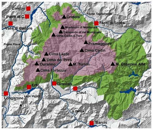
Dolomiti Friulane e d’Oltre Piave
Dolomiti Friulane and d'Oltre Piave map
Dolomiti Friulane e d’Oltre Piave
Surface: 21461 hectares Buffer zone: 25027 ha. Coordinates: N46 20 48.00 E12 30 13.00 Provinces: Belluno, Pordenone, Udine Parks and Nature reserves: Dolomiti Friulane Natural Park Main peaks: Cima dei Preti m. 2706, Duranno m. 2652, Cridola m. 2581, Cima Monfalcon m. 2548, Cadin di Toro m. 2386, Campanile di Val Montanaia m. 2173
Belonging to three different provinces, this system is the Easternmost amongst the nine ones and one of the wildest and unexplored territories of the Dolomites. The area is located amongst the Piave river, the upper section of the Tagliamento river, the Tramontina Valley and the central section of the Cellina Valley. The altitude doesn't overcome the 3000 meters, but the environment is quite wild.
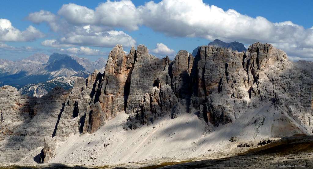
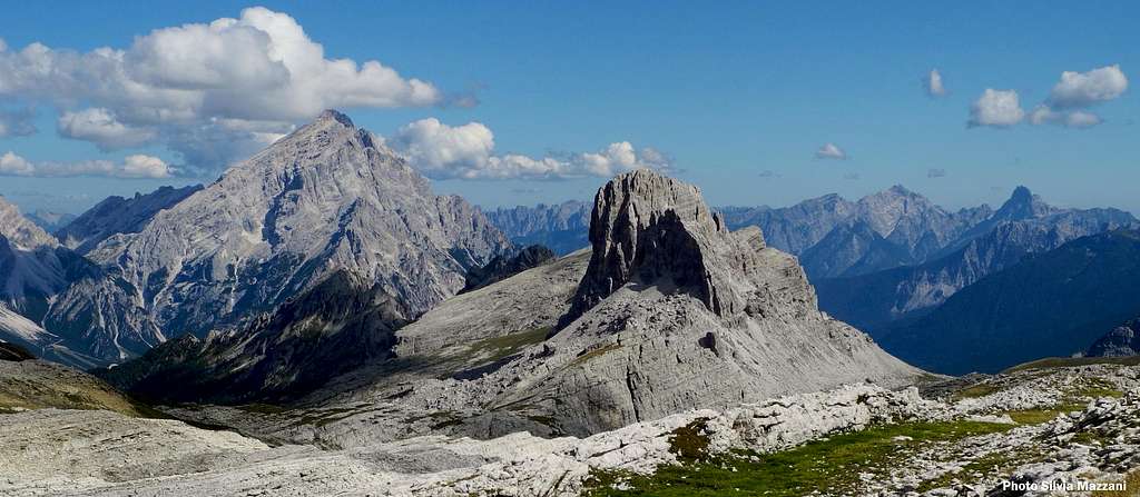
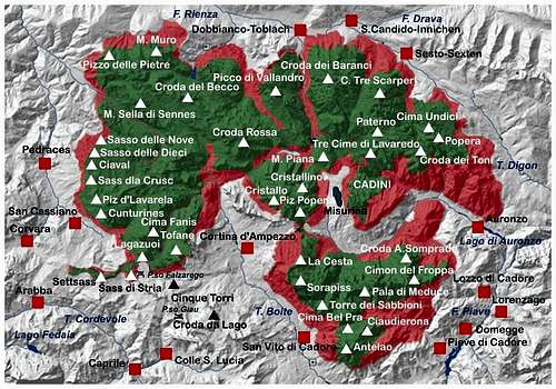
Dolomiti Settentrionali – Northern Dolomites
Northern Dolomites map
Dolomiti Settentrionali – Northern Dolomites
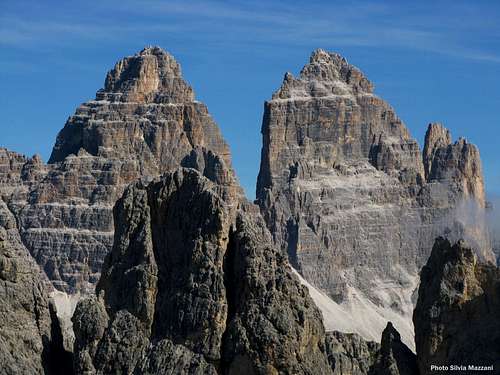
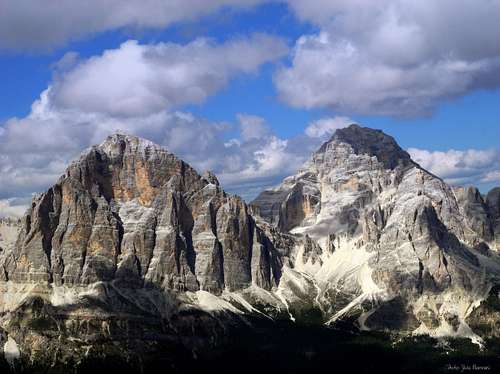
Surface: 53586 hectares Buffer zone: 25182 ha Coordinates: N46 36 47.00 E12 9 47.00 Provinces: Belluno, Bolzano Alto-Adige Parks and Nature reserves: Fanes-Sennes-Braies Natural Park, Sesto Dolomites Natural Park, Ampezzo Dolomites Natural Park Main peaks: Antelao m. 3264, Tofana di Mezzo m. 3244, Tofane de Inze m. 3238, Tofana di Rozes m. 3225, Cristallo m. 3221, Sorapiss m. 3205, Punta Tre Scarperi m. 3152, Croda Rossa m. 3146, Croda dei Toni m. 3094, Cima Grande m. 2999 (Tre Cime di Lavaredo), Marmarole m. 2932, Cadin di San Lucano m. 2839 (Cadini di Misurina)
Shared between Belluno and Bolzano, this system is the Northernmost and the largest of the nine ones, bounded by Pusteria Valley, Sesto Valley, Badia Valley, S. Cassiano Valley in Bolzano province and Piave Valley, Boite Valley and Ansiei Valley in Belluno province. It is the area which best meets the criteria of outstanding aesthetic with the geological and geomorphological value; moreover it counts some Nature Reserves and it is composed by different mountain groups, as Cadini di Misurina, Dolomiti di Sesto, Tre Cime di Lavaredo, Tofane, Fanis, Sennes-Braies, Cristallo and Dolomiti Cadorine, enumerating some of the highest peaks of the Dolomites, as Antelao, also called the "King of the Dolomites" - being the second highest peak after Marmolada - Tofane, Cristallo and Sorapiss.
Cima Ovest, Cima Grande and Piccola di Lavaredo
Tofana di Rozes and Tofana di Mezzo
Sorapiss and Marmarole seen from Antelao
Puez-Odle
Puez - Odle map
Puez-Odle
Surface: 7930 hectares Buffer zone: 2863 ha Coordinates: N46 36 13.00 E11 48 24.00 Provinces: Bolzano Alto-Adige Parks and Nature reserves: Puez Odle Natural Park Main peaks: Sass Rigais m. 3025, Sass de Putia m. 2875, Sassongher m. 2665
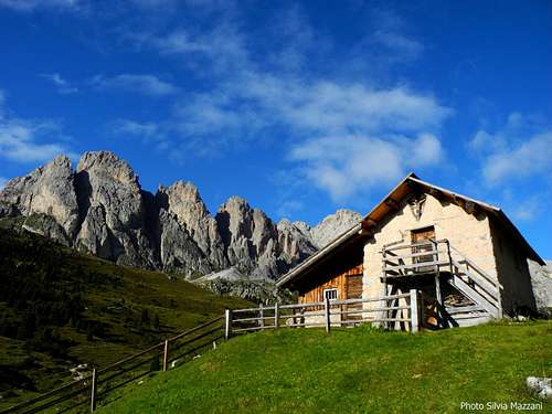
This system lies inside the Natural Park “Puez-Odle”, established in 1978, and it’s bounded to the North by Funes Valley, to the South by Gardena Valley and to the East by Badia Valley. Puez-Odle provides a great representation of the typical landscape of the Dolomites, with pinnacles, peaks and wide karst tablelands. The climatic, glacial and landslide phenomena are still active and the rocks give an example of the geomorphologic effects. The Northern sector shows the two secluded massifs of the Odle, testifying the isolation of the primary sea-cliffs. The Southern sector shows the Gardenaccia vaste karst tableland. Here you can admire the complete stratigraphy of the Dolomites, from the Permian to the Cretaceous.
Alpe di Cisles
Sunset on Piccola Fermeda and Gran Fermeda
Odle Group seen from Sella Pass
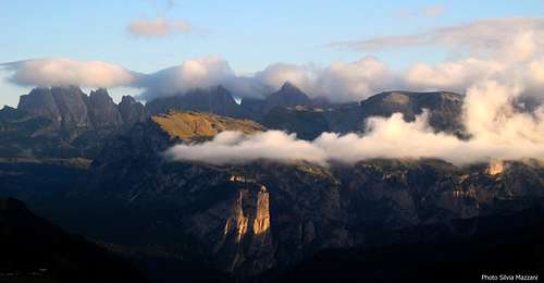
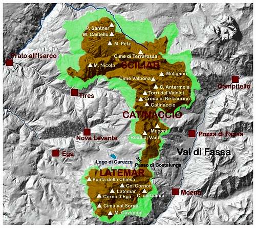
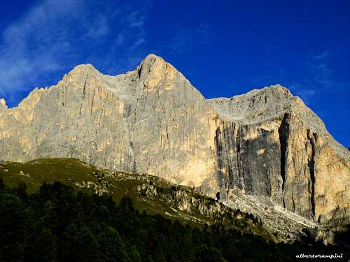
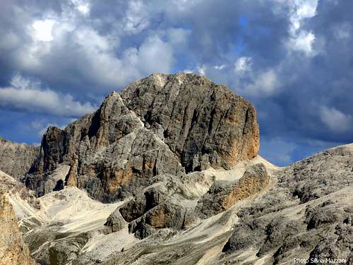
Sciliar-Catinaccio and Latemar
Sciliar-Catinaccio and Latemar map
Sciliar-Catinaccio and Latemar
Surface: 9302 hectares Buffer zone: 4770 ha Coordinates: N46 27 16.00 E11 36 10.00 Provinces: Bolzano, Trento Main peaks: Catinaccio d’Antermoia m. 3002, Catinaccio m. 2981, Campanili del Latemar m. 2842, Cima Val Bona m. 2822, Molignon m. 2820, Torri del Vajolet m. 2813, Roda di Vael m. 2806, Cima di Terrarossa m. 2580, Punta Santner m. 2413
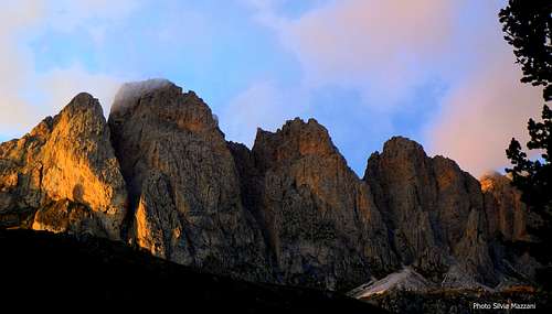
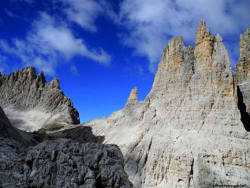
This system is shared between the provinces of Bolzano and Trento and can be divided into two separate sectors: Sciliar-Catinaccio to the North and Latemar to the South. Sciliar and Catinaccio are bounded to the North-West by the Isarco Valley, to the North by Tires Valley and to the East by Fassa Valley, and joined through the Forcella Terrarossa. Latemar, which was an ancient secluded atoll, is bounded to the West by Ega Valley and to the East by Fiemme Valley and it is separated from Catinaccio by the Costalunga Pass. It is one of the most important systems worldwide for the study of the stratigraphy of the Triassic, in reason of the plenty of fossils on Alpe di Siusi, the relationship between carbonate and volcanic sediments, and the fact that the outcrops are easily accessible. Catinaccio, with the stunning Vajolet Towers, forms a series of peaks and sharp needles showing the movement of an island which sank into the sea 240 million years ago.
Catinaccio East face
Catinaccio d'Antermoia
Torri del Vajolet
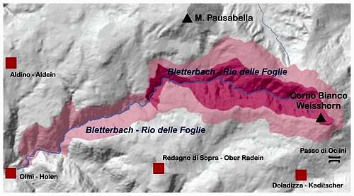
Rio delle Foglie - Bletterbach
Bletterbach - Rio delle Foglie map
Rio delle Foglie - Bletterbach
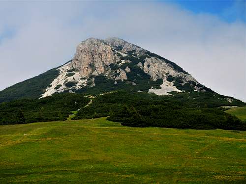
Surface: 271 hectares Buffer zone: 547 ha. Coordinates: N46 21 37.00 E11 25 14.00 Provinces: Bolzano Alto-Adige Natural monument: Bletterbach Parks and Nature reserves: Bletterbach Geopark Main peak: Corno Bianco 2317 m
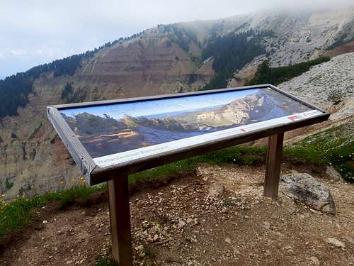
Small but exceptional system located at the foot of the Weisshorn inside a valley to the West of Passo Oclini - Joch Grimm and belonging to Bolzano Alto-Adige province, this deep canyon was hollowed out by the water through the millenniums and provides a detailed visual representation of the geological history of the Dolomites.
The Dolomites UNESCO Geopark BletterbachThe lone Weisshorn (Corno Bianco)
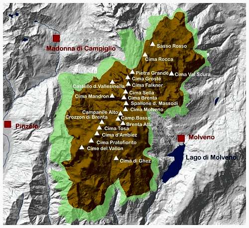
Dolomiti di Brenta - Brenta Dolomites
Brenta Dolomites map
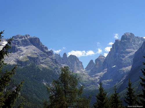
Dolomiti di Brenta - Brenta Dolomites
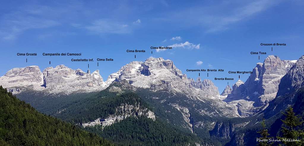
Surface: 11135 hectares Buffer zone: 4201 ha. Coordinates: N46 9 51.00 E10 54 9.00 Province: Trento Parks and Nature Reserves: Adamello-Brenta Natural Park (Unesco Geopark Adamello Brenta) Main peaks: Cima Tosa m. 3173, Cima Brenta m. 3150, Crozzon di Brenta m. 3118, Cima d’Ambiez m. 3102, Cima Vallesinella m. 3114, Cima Brenta Alta m. 2960, Campanile Basso di Brenta m. 2877
This wide range lies inside the Natural Park “Adamello-Brenta”, established in 1988, and it’s bounded to the North by Sole Valley, to the West by Rendena Valley, to the South by Giudicarie Valleys and to the East by Non Valley. It’s the Western most system, the only one amongst the nine lying on the right orographic side of the Adige Valley and entirely belonging to the province of Trento. It’s a secluded cathedral of “dolomia”, solemn and austere, shaped with imposing and high peaks, variously shaped pinnacles, gullies, rocky tablelands and small glaciers named “Vedrette”.
Brenta Dolomites from Val Rendena
The Rendena Valley represents a clear division between the carbonate platform of Brenta Dolomites and the intrusive rocks of the neighbouring Adamello and Presanella Groups. Brenta Dolomites are divided in: Ambiez Chain, Tosa Massif, Sfulmini Chain, Cima Brenta Massif, Grostè Massif, Gaiarda and Altissimo Subgroup, Campa Subgroup and Northern Chain. The system enumerates some of the most important 3000ers of the Dolomites, as Cima Tosa m. 3173 - the highest peak - and Crozzon di Brenta m. 3118.
Given that Dolomite is different from limestone because of the magnesium, I'm curious as to how that came about. Where the original coral reefs already different in that they contained magnesium, or was there some other process where part of the calcium was somehow replaced by magnesium later on?
Good question, indeed, Rob. I am not a geologist, but i think that the particular ambient existing during the process of building could have turned the calcium in magnesium.
You can take a look here: http://it.wikipedia.org/wiki/Dolomia
Thanks and cheers!
Silvia
looking page and the photos are stunning. I wish I had another lifetime to explore such a beautiful place. I spent months planning and saving money for a trip to the Alps and Dolomites back in the 70s but I impulsively blew it on my first new car. These pictures make me regret that decision to this day. :-)
Excellent article, incredible detail and awesome photos, must have been a lot of work. Thank you for providing this resource.
I headed to the Dolomites for a hut to hut hiking trip in the spring of 1995 as part of my two month trip to Italy and German, but the cold spring and big snow of the previous winter still lingered in the alpine, so we went and drank beer in Bavaria instead. I would love to return to climb one day.
Thanks, friend! Yes, a long work indeed...anyhow all your estimations make me happy and mean that it had been not useless! Also the current year spring is cold and rainy and there’s a lot of snow in the Dolomites. Sometimes it happens! The best season to visit this area is the summer, particularly September. Anyhow, if you'll return, i will be happy to give you all the info you'll need.
Cheers, Silvia
Silvia this article is AMAZING! Great compilation job and great images, I[ll definately bookmark this as reference for future trips to the area. Thank you!
The Dolomites rise in their majesty
On this hot summers day.
Rugged stragglers hug the side of the mountain slopes
Cheering on a lone figure.
Squadra buses grunt up the grade
And the commisairs’ motorcycle is pulling sure
Ten meters back.
Coppi does not see the road ahead
Or hear the cheers from his tifosi.
He only drives his fuel burning legs
Against gravity
Until the stage is done.
Inspiring! Thanks Windsor for your homage to this great champion of antan! Giro d'Italia is running now and next Thursday it will pass just in front of my office! Anyhow Coppi is gone and nowaday there are not the same champions!
Thanks Sylvia. That is cool for you. I guess everyone will take a break at work to watch the tour.
Yes, so much doping. Hard to compete at that level when everyone is looking for an edge. I saw the movie "The Armstrong Lie" A very good movie that takes an in depth look at the use of drugs in professional cycling. A candid interview with Lance where he flat out confesses in detail how he got away with it all that time. I believed him. He was cetainly convincing. But my french landlord cyclist friend knew better all along! ;))
Thanks also to you, Windsor. Yes, only a little break from work, but pleasant! Doping? Unfortunately there's much doping, and not only in professional cycling! Anyhow, now Giro d'Italia is running towards the Alps! Unforgettable duels!
Children refers to the set of objects that logically fall under a given object. For example, the
Aconcagua mountain page is a child of the 'Aconcagua Group' and the 'Seven Summits.' The
Aconcagua mountain itself has many routes, photos, and trip reports as children.
Parents refers to a larger category under which an object falls. For example, theAconcagua mountain page has the 'Aconcagua Group' and the 'Seven Summits' asparents and is a parent itself to many routes, photos, and Trip Reports.


Comments
Post a Comment