
-
 7390 Hits
-
 73.06% Score
-
 3 Votes
|
|
Route |
|---|---|
|
|
48.33580°N / 113.7761°W |
|
|
Bushwhack/scramble |
|
|
Most of a day |
|
|
Class 2-3 |
|
|
Approach
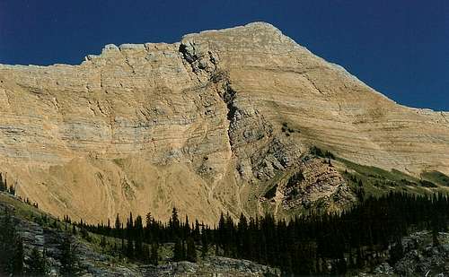 View from 6800' knob
Be aware-- this is neither the standard nor the easiest route! This is for people who like rugged bushwhacking and cross-country travel and will accept them as the price of solitude. It is also for people who like suffering even when an easier way is nearby. It took my brother and me about six hours in all and would have taken four if I'd been alone or if my brother had had good footwear, but this route will take the average hiker about eight hours (RT), maybe longer. This route is fun and I'm glad I did it-- there's a true sense of accomplishment-- but I would take the standard route if I had to do it again.
Getting There: Follow the east side of Hungry Horse Reservoir from the village of Hungry Horse on FR 38 (according to USGS topo maps) for several miles (around 15)and then turn left on 1048. This is a very sharp left, and you follow this road for about a half-mile to a bridged crossing of Hungry Horse Creek. Right after crossing Hungry Horse Creek, you will find a small parking area on the left, and it will likely be empty.
There are no signs indicating the way to the trailhead, and route signs may be nonexistent, so carry a good map and consult it as you drive.
Route Description
 From Dudley Bowl
Enter the forest to the right of Hungry Horse Creek. There is no trail, and the forest is dense in many places. Trekking poles would be helpful to test footing since the real ground is often hidden beneath several inches' worth of rotting leaves, wood, and God knows what else. Footing is bad and the grade is steep, but you must work uphill (right) until you reach the ridgeline, where the trees and underbrush thin, a use trail appears, and views start to open up. Work your way to a knob at 6800', where you will have a spectacular view of Great Northern. Going in a straight line, it is about 1.5 miles to the knob and 2.5 to the summit, but you will not go in a straight line-- the forest will do its best to beat you back. Upon attaining the knob, bask in the good news that the bushwhacking is over, but take it in good stride that you have to descend almost 150' before you reach the snow-filled bowl at the base of Great Northern and begin the summit climb. This spot, according to the Falcon Guide, is Dudley Bowl. It is not named on the Mount Grant quad.
[img:523816:aligncenter:medium:From Dudley Bowl]
From the bowl, head northwest on talus slopes to reach the northwest ridge, where a use trail goes to the summit and affords incredible views of the Stanton Glacier, the Flathead Range, and southern Glacier National Park along the way. Or you can opt for the shorter but more demanding way and go straight up the mountain as I did-- be prepared for loose rock and some Class 3 scrambling. I did not see a register at the summit but did, unfortunately, see the graffiti from past peakbaggers. Please don't add to it.
[img:128407:aligncenter:medium:Summit]
To descend, I recommend returning to the knob and following the ridge back to the road, where you will have to turn right to get back to your car. I say this because the ridge was easier to travel than the other parts below timberline were. Or continue descending the Northwest Ridge and, instead of returning to Dudley Bowl, find and follow the trail that goes along the north side of Hungry Horse Creek and leads back to the parking area. Of course, you can also go back the way you came.
Do not, unless you want some real adventure, do what I did-- not wanting to reclimb the knob after all the work I'd already done, I thought it would be a good idea to find and follow Hungry Horse Creek back to the car.
I had to negotiate wet cliffs, waterfalls, and seemingly ubiquitous thorns, and I faced a classic no-win situation-- the vegetation by the creek, the direct route, was often so dense, muck-laden or both that it was impassable (and it was often over my head, raising the chances of a surprise encounter with a bear), and the steep hillsides meant terrible footing and dense growth that seemed to push me down to the creek, anyway. Eventually, I just gave up fighting the greenery and went through the creek, and that was easier and faster than anything else I faced below timberline that day. The cold beer waiting in the car as I returned at sunset (my brother and I started at about 2) just might have been the best beer I've ever had.
The upshots-- true wilderness, solitude, and an encounter with the namesake of the Great Bear Wilderness-- what better place for it? In a relatively open spot near the creek, I startled a young male grizzly perched on a boulder. He flew up the hillside and away from me after a momentary locked-eyes moment that said "Oh shit" from both sides. My can of pepper spray stayed in my hand most of the rest of the way. I can only imagine what might have happened if our meeting had occurred in one of those places where the "undergrowth" was over my head.
Be prepared and be respectful. This is an exhausting trip, but it is one of the best I have ever taken.
Essential Gear
Good hiking boots and thick socks-- my brother wore sandals and paid for it in blood and twists. If it's not too hot, wear pants instead of shorts-- you will scrape and cut your legs during the bushwhacking if you are in shorts (as I was).Trekking poles help in the trees but hinder you on the rocks. You decide, but be aware that the bushwhacking is the hardest part of this climb.