
-
 12135 Hits
-
 75.81% Score
-
 6 Votes
|
|
Trailhead |
|---|---|
|
|
48.35138°N / 113.83983°W |
|
|
Flathead |
|
|
Spring, Summer, Fall, Winter |
|
|
4170 ft / 1271 m |
Great Northern/Mount Grant Trailhead
 Mount Grant
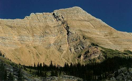 Great Northern Mountain, Bob Sihler photo.
 Trailhead Map
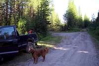 Trailhead
 Bridge near trailhead
 Start of Standard/Northwest Ridge Route
Mountains Accessed:
Great Northern Mountain
Mount Grant
Routes Accessed:
The Standard/Northwest Ridge Route as described by saintgrizzly is located on the North side of Hungry Horse Creek and the Dudley Bowl Route by BobSiler is located on the South side of the creek.
Getting to the Area
The Great Northern Mountain/Mount Grant Trailhead is located on the east side of Hungry Horse Reservoir. It is located approximately 12 miles from West Glacier, Montana and about 5 miles from Hungry Horse, Montana.
The town of Hungry Horse was named after two draft horses used for logging the area when they wandered off during the severe winter of 1900. The horses, Tex and Jerry, were found a month later, all scraggly and hungry but very much alive.
Make sure to stop by Willow’s Huckleberry Land and have a huckleberry milkshake and visit Hungry Horse Dam as well.
Hungry Horse has a population of less than 1,000 people and there is not much else to see that is not on U.S. Highway 2 as it runs through town.
Hungry Horse is always amusing to visit on July 4th and the annual winter barstool races in Martin City are legendary as well. No really they race on barstool with skis.
Sp member samh added that there is a FREE wildgame feed every Wednesday night at the Dew Drop Inn between Coram and West Glacier.
From the West:
To reach the Eastside Dam Road when traveling East on U.S. Highway 2 from the Flathead Valley towards Glacier National Park drive east of Hungry Horse, Montana for approximately 1 mile to Martin City.
From the East:
When traveling West from Glacier National Park pass through Coram and then look for The Packer’s Roost and then look for the sign that indicates a left hand turn to Martin City.
The Forest Service Road:
After turning into Martin City follow the Eastside Hungry Horse Reservoir until the pavement ends in two miles or so. How enjoyable the next 13 miles is will depend on how long it’s been since the road was graded. It has been know to be full of potholes and washboards at times but other times it has been an excellent drive. Still do not expect to drive over 35 mph due to the numerous curves.
While traveling through the Coram Experimental Forest expect to see deer and other smaller forest creatures. Access to Hungry Horse Reservoir is available at both Abbot Bay and Emery Bay. There is overnight camping available at Emery Bay as well.
After passing Emery Bay turnoff travel another 8.7 miles to the unmarked road #1048. This is a SHARP left hand turn located in that direct vicinity of Road #1048 is a sign that reads Firefighter Mountain 4 as well as Spotted Bear 39.
The trailhead is another ½ mile up this road. There is parking before and after the bridge. Please do not block the gates.
The Weather:
Plan on checking the weather before climbing for views and to prevent exposure to thunderstorms in the afternoon. Elevation Gains From Trailhead to Summits:
Great Northern Mountain, Elevation gain = 4,425 feet
Mount Grant, Elevation gain = 4,310 feet, Route climbs over Great Northern Mountain and has additional gains and losses.
samh - Oct 29, 2008 2:43 pm - Voted 10/10
Stop OffsIf you're going to mention places to stop off, then mentioning the free wild game feed every Wednesday night at the Dew Drop Inn is probably worthwhile ; )