
|
|
Mountain/Rock |
|---|---|
|
|
40.36920°N / 107.7678°W |
|
|
Moffat |
|
|
Hiking, Trad Climbing, Toprope, Bouldering, Scrambling, Skiing |
|
|
Spring, Summer, Fall, Winter |
|
|
7096 ft / 2163 m |
|
|
Overview
Duffy Mountain is a low mountain made of sedimentary rock in Northwest Colorado. The mountain isn’t very high, but does cover a rather large area being about eight miles long and about 2.5 miles wide. Rather than alpine, the mountain is a fairly barren “cold desert” mountain. The mountain is near both the Williams Fork and Mountains and Danford Hills, but doesn’t appear to be a part of either range and is independent of a mountain range.The weather is harsh and dry. Sunny skies predominate, but winter temperatures plunge to -40 or lower in the winter and rise to the upper 90’s in the summer. Nearby Maybell holds the distinction of being the place where the lowest temperature in Colorado was recorded at -61F (-52C). Summer temperatures have topped 100F (38C).
Vegetation is relatively sparse consisting of grass and scrubland, but the mountain holds a population of elk, deer, bighorn sheep, black bears, cougars, rattlesnakes, and other wildlife.
The area was inhabited by ancient Native Americans and pictographs on the mountain along the Yampa River are thought to be several thousand years old.
The trailheads for the mountain can be accessed by road from the south and west sides and by river (canoe, kayak, or raft) on the north and east sides. Unfortunately, there is a road to the upper sections and main ridge of the mountain, but luckily there are several good hiking routes as well. There are no hiking trails on the mountain, but there are plenty of cross country routes and a few historic old sheep trails that access the top of the mountain.
There are bands of cliffs on the mountain that impede access from many routes. Unfortuantely much of the rock is soft, but fortunately some of it is hard and good for rock climbing. Local climbers have put several routes up on the cliff bands.
The interpolated contour line elevation for the mountain is 7100 feet when using the 7.5 minute maps. Topozone gives an elevation of 7096 feet, but I don’t know the source. The 1:250,000 map gives a spot elevation of 7087 feet which may be for the highest point.
 This is Duffy Mountain as viewed from the south on October 20 2007.
Getting There
Via County Road 17 to the Bone TrailCounty Road 17 connects Highway 40 with Highway 13. To reach the road from the north, drive to the tiny hamlet of Lay along Highway 40. This is about 19 miles west of Craig or 11 miles east of Maybell. Follow the County Road south to a junction. Stay left and follow the main road until the main road crosses the Yampa River. Set your trip meter here. After four miles there is a cattle guard and left turn for “River Access”. Continue straight (right) along the main road for about another mile. Keep a close eye on the left side of the road for a faint track heading north. Drive as far as you can along the track and park. This used to be a pretty good road, but the floods of September 2007 washed a lot of the road out. Our Subaru only made it half way.
To reach County Road 17 from the south, drive south of Craig along Highway 13 past Hamilton and several miles past this to the signed turnoff for Duffy Mountain or drive Highway 13 north of Meeker to the turnoff. I don’t know the exact mileage from either town, but the road is well signposted.
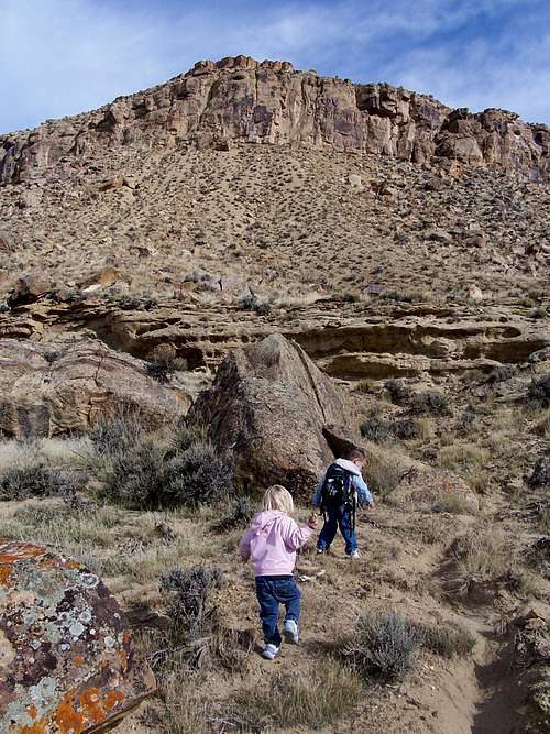 Kessler and Shaylee near the beginning of the Bone Trail. This is an old historic sheep trail that I stumbled across one day when exploring around. Much of the route has been reclaimed by nature, but much of the trail is still visible. My kids like to call it the Bone Trail as apparently not all animals that attempted the trail made it through for some reason and their bones are scattered along parts of the trail.
Via Yampa River
You can reach the northern side of Duffy Mountain via canoe, kayak, or raft via the Yampa River. The launch point is just south of Craig along Highway 13 and right where Highway 13 crosses the Yampa River. It cost $5 a vehicle to park and launch a boat here. The take out point can be at the “River Access” Road mentioned above. It is a two day float to this point, including a climb of the mountain.
 As mentioned on the mountain page, there are two ways to access Duffy Mountain. One is via Overland from the southwest and one is via the Yampa River from the northeast. The lower slopes of Duffy Mountain are pirctured here in the photograph. May 2007.
Routes Overview
There are many routes up Duffy Mountain varying in degree of difficulty. These are only a few possibilities.Southwest Side
One of the best routes that I have found is via an old historic sheep trail that I stumbled across one day. Much of the route has been reclaimed by nature, but much of the trail is still visible. My kids like to call it the Bone Trail as apparently not all animals that attempted the trail made it through for some reason and their bones are scattered along parts of the trail.
 One of the best routes that I have found is via an old historic sheep trail that I stumbled across one day. Much of the route has been reclaimed by nature, but much of the trail is still visible.
Northwest Point
Coming in from Signal Butte to the northwest is easy, but with the road and flat ridge, not very interesting. If you are a hiker or climber this route would be interesting is if there is enough snow to cross country ski it. In mid winter there is often enough snow to do this. However one suggestion for a good hike is to follow the ridge up to the ridge crest for a while and then head south to the escarpment on the south face. There are game trails and sheep trails along the escarpment which makes a nice hike with some great views.
 From the top of the South Face escarpment of Duffy Mountain looking west. Juniper Mountain is in the background.
Northeast Side
This side of the mountain is accessed from the Yampa River (via canoe, kayak, or raft) and affords several interesting routes. It would make a nice break from an otherwise rather tame and at times unexciting run.
 These are the lower northern slopes of Duffy Mountain as seen from the Yampa River.
East Side
The East Side from Milk Creek looks fairly interesting, but make sure to do it at the northern end to avoid some private ranch lands.
Red Tape
There is no red tape here other than vehicles must stay on designated routes on the public lands.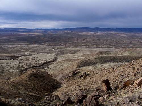 Looking north from about half way up Duffy Mountain and along the Bone Trail. October 20 2007. No real red tape around here.
Camping
There is one campground in Maybell itself, and one outside and just to the west of Maybell where Highway 40 crosses the Yampa River. Both have a small fee, but don't take reservations. The campground is seldom, if ever full though.Craig has a KOA as well.
Duffy Mountain is surrounded by much BLM land and you can camp almost anywhere (no facilities) outside private land.
When to Climb
April through early June is best. Snowdrifts usually last until sometime in April and for a few weeks after that it can be muddy. This is the high desert with some of the widest temperature ranges in the country. As mentioned, in Maybell, temperatures have varied from 102 in the summer, and -61 in the winter. Summers are warm and can be hot. It can be in the 90's, and there are no reliable water sources on the mountain and there are many rattlesnakes. Winters are cold, and the winter extremes are sometimes rediculously low here. It may surprise some to here that the lowest temperature ever recorded in Colorado (-61), happened not in the high mountains, but at Maybell, at only 5920 feet elevation and right near Duffy Mountain. In the winter months, temperatures of -40 are fairly common, without the windchill.The mountain could be climbed in winter, but the south facing slopes won’t hold much snow and could be muddy. From the south it might be better when the mud is frozen. The other more shaded slopes and the ridgetop can hold enough snow for skiing or snowshoeing, especially mid December through early March.
September and October can have pleasent temperatures as well, but Northwest Colorado is a popular hunting destination, though I’ve never seen hunters on Duffy Mountain and it appears that they are usually elsewhere. If you go then, you may want to wear blaze orange just to be safe. November often isn’t too bad either and can be a great time to climb.
If you are approaching the mountain from the river May and June are the ideal times to climb since that is when the river is ideal to run.
 A large rattlesnake seen on our climb of Duffy Mountain on October 20 2007. As soon as my son Kessler heard it rattling he stopped in his tracks and asked "what's that noise?" I showed him the rattlesnake and we promptly took the long way around. Rattlers blend in well with the landscape and can be hard to spot. Luckily they usually give fair warning to stay away.
Mountain Conditions
CLICK HERE FOR WEATHER FORECAST FOR DUFFY MOUNTAINWeather and climate data for Maybell at 5920 feet elevation is below. *National Weather Service Data 1958-2004.
| MONTH | AVE HIGH | AVE LOW | REC HIGH | REC LOW | AVE PRECIP (in) |
| JAN | 33 | 2 | 56 | -60 | .79 |
| FEB | 38 | 7 | 66 | -61 | .84 |
| MAR | 48 | 18 | 75 | -21 | 1.03 |
| APR | 59 | 26 | 82 | 0 | 1.35 |
| MAY | 70 | 33 | 91 | 10 | 1.13 |
| JUN | 80 | 40 | 96 | 22 | .93 |
| JUL | 87 | 47 | 102 | 26 | .85 |
| AUG | 85 | 45 | 98 | 28 | .89 |
| SEP | 75 | 36 | 94 | 8 | 1.10 |
| OCT | 63 | 25 | 87 | -10 | 1.20 |
| NOV | 46 | 15 | 70 | -24 | 1.15 |
| DEC | 35 | 4 | 61 | -50 | .89 |