
|
|
Mountain/Rock |
|---|---|
|
|
40.45600°N / 109.2144°W |
|
|
7220 ft / 2201 m |
|
|
Overview
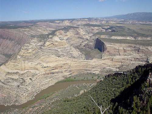
Split Mountain is near the eastern most extent of the Uinta Mountains. It bears little resemblance to most of the Uintas and has a much more desert-like appearence instead of alpine meadows. Split Mountain gets it's name because the mountain has been "split in two" by erosion forces from the Green River. The mountain is a huge anticline, which amazingly, the Green River has cut Split Mountain Canyon right through the center and highest part of the anticline. The setting is very spectacular because the bent rock layers and geology has been exposed. See this photograph taken of the eastern ramparts of the mountain, near Harpers Corner. Note also that the USGS maps label just the northwestern half of the mountain as "Split Mountain". In reality, JW Powell named both sides of the river Split Mountain. Despite being a rather locally famous landmark, the summit is very seldom visited. There are no trails up the mountain. Several scenic canyons cut through the south slopes of the mountain, which are made of a massive sandstone formation. There are several archeological sites on slopes of the mountain as well.
Since the USGS does not label this mountain, there are various opinions as to how far east Split Mountain extends and how many summits are included. Some locals consider the mountain to extend to Harpers Corner, and others just to the connecting saddle with Yampa Plateau. For this reason I went to the source. In reading Exploration of the Colorado River and its Canyons by JW Powell, it seems that Split Mountain was named in 1869 for the mountain on either side below Wirlpool Canyon. Because of this I am considering the eastern most extent of Split Mountain as the connecting saddle with the Powell Plateau. Harpers Corner and Ruple Point won't be considered as part of Split Mountain itself, but will be mentioned as this page as side notes and references. Different sources may differ.
I have traveled the world across six continents, and I would rate the view from the summit of South Split Mountain as one of the best in the world.
For the north half of Split Mountain, CLICK HERE.
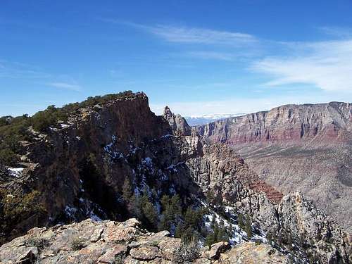 Eastern Summit (left), Central Pinnacle (just to the right of the east summit), and Split Mountain (right).
Summits of South Split Mountain
The topo maps give three points on the map with closed 7,200 foot contours. The summit I have climbed and the one in the route description is the eastern summit, just before the connecting saddle with the Yampa Plateau. The eastern summit is a farily easy off-trail ascent.
It is my belief, however, that the "Central Pinnacle" is at least a bit higher and certainly is the true summit of the mountain.
Climbing the Central Pinnacle technical climbing, up to at least 5.9 in difficulty. In fact, the true summit wasn't reached until May 12 2012. SP member Drew reports loose and brittle rock.
Desert Rock IV mentions some climbs up pinnacles on the lower slopes and mentions that pinnacles on this mountain are unclimbed, but doesn't state which ones. All the western peaks and summits appear to be very difficult technical climbs as well. The National Park Service has no information on the Central Pinnacle or on any routes to Split Mountain, and this area is only briefly mentioned in one guidebook. No other sources seem to be available.
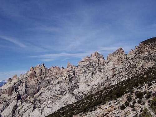 Various summits of South Split Mountain as viewed from along the Bighorn Route.
Getting There
To get to the trailhead, drive to the small town of Jensen. This is located between Vernal and the Colorado/Utah state line on Highway 40.
From Jensen, turn north on Highway 148 and the road marked for Dinosaur National Monument. Drive through to the entrance station and continue along the paved road. Take a right on the road posted for the campground. Drive past the campground (don't turn left to the campground), cross the Green River on a bridge and reach another junction. Turn left on the road marked for the petroglyphs and the Josie Morris Cabin. Once you cross the park boundary, look for a place to park.
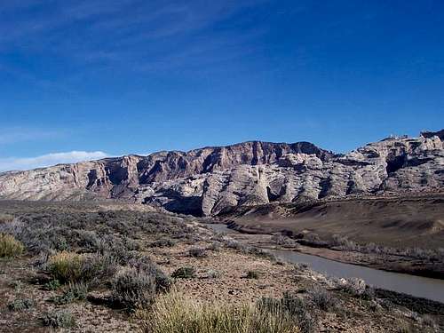
There are other ways to climb South Split Mountain. A shorter route would be to cross the Green River at the Split Mountain Picnic Ground and boat ramp, but you would need a boat for this. The Daniels Ranch blocks any other shorter routes to the mountain, and the route on the route page bypasses any ranch land.
 Eastern extent of the main summit of Split Mounain. As viewed from South Split Mountain.
Routes Overview
There are no marked trails to any summits. As mentioned above, most of the summits of East Split Mountain can only be climbed with big wall experience and gear. Desert Rock IV mentions routes to a few of the lower towers, and I would suggest reading that book for more information. The BIGHORN ROUTE reaches the east summit, which I believe is actually the second highest summit of the mountain. I call this route the Bighorn Route because there is often a bighorn sheep trail and due to the fact of many bighorn tracks and other "evidence", it appears that the route is frequently climbed by bighorn sheep. The route on the page is just one of the possible routes to the east summit, and it appears that many routes are available if you wish to find and climb them. It would also certainly be possible to hike west from the Yampa Plateau from a turn-off off the Echo Park Road and to the summit.
On one trip to Hog Canyon (just east of the Bighorn Route trailhead), one evening Steve Mesteg and I hiked and climbed up Hog Canyon. Though the Park Service sign at the first climb in the canyon warns people that they shouldn't continue, we did so for quite aways and didn't find anything more difficult than low 5th class moves. This appears to be an excellent, but not too difficult technical route to the ridgeline.
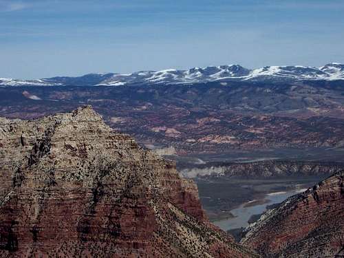
 View south from along the Bighorn Route.
Harpers Corner and Ruple Point Overview
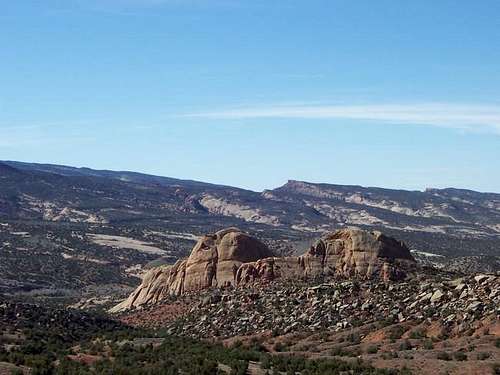
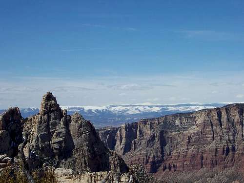
These two locations/points deserve mention. For the purposes of this page and my research (see above), these points are seperate from Split Mountain and will be only breifly mentioned. Both are excellent places to visit for those who don't desire to climb to the summit of South Split Mountain. The National Park Service sign at Harpers Point at the end of the Harpers Corner Trail claims that the view is the "best view of any trail in a National Park". Though this may be a bit biased on the account of the sign maker, the view compares very well with any of the more famous viewpoints in the National Park System. Either viewpoint is very spectacular.
 View from Harpers Corner.
Red Tape
Federal law protects all archeological sites. Do not disturb them.
A free permit is needed for overnight camping in the backcountry.
Park entry cost $10 per vehicle in 2005.
When To Climb
The best times to climb this mountain are April, May, September, October, and early November. Summer is very hot, winter very cold. This route faces south, so expect it to be hot in summer, and the spring snows leave fairly early. See the weather chart below. These are just averages however, as in Spring or Fall you can either roast or freeze, often on the same day! This is a land of extremes and it is not uncommon to have the afternoon be sixty degrees warmer than in the morning. At the quarry, an average night in January is 4 degrees, and an average day in July is 95 degrees, but temperatures have been as low as -40 or as high as 110.
 Central Pinnacle (left), Split Mountain (right) as viewed from the eastern summit. as viewed in April.
Camping
There are several campgrounds including the Split Mountain campground which is close to the trailhead, but it is now only a group site. Also close to the trailhead is the Green River Campground. For more information call the park headquarters at 801-789-2115.
 Split Mountain (left), South Split Mountain (right) as viewed from near the campground.
Mountain Conditions
Contact the rangers at the Dinosaur National Monument Headquarters at 801-789-2115 for updated conditions.
Here is a link to the monument web page.
WEATHER FORECAST FOR SPLIT MOUNTAIN
Weather and climate data for the Dinosaur Quarry is below. *National Weather Service Data 1958-2004.
| MONTH | AVE HIGH | AVE LOW | REC HIGH | REC LOW | AVE PRECIP (in) |
| JAN | 30 | 4 | 60 | -39 | .51 |
| FEB | 39 | 11 | 66 | -40 | .62 |
| MAR | 54 | 24 | 85 | -13 | .65 |
| APR | 65 | 33 | 89 | 10 | .78 |
| MAY | 77 | 41 | 103 | 20 | .86 |
| JUN | 88 | 49 | 105 | 30 | .61 |
| JUL | 95 | 55 | 110 | 38 | .62 |
| AUG | 92 | 53 | 106 | 35 | .64 |
| SEP | 82 | 44 | 103 | 20 | .98<TD |
| OCT | 67 | 32 | 93 | 2 | 1.06 |
| NOV | 49 | 22 | 74 | -10 | .60 |
| DEC | 35 | 10 | 61 | -33 | .56 |
Pictographs and Petroglyphs
South Split Mountain has several pictograph and petroglyph panels on its lower slopes. Pictographs are painted on the rocks and petroglyphs are chipped into the rock. The Fremont Culture chipped the petroglyphs 1500 to 2500 years ago. It used to be theorized that the Fremonts also left the pictographs, but more recent studies and with advancement in chemical dating, these are know known to be much older. The pictographs on South Split Mountain are actually 3000-8000 years old.
On the lower slopes of the mountain, there is one panel of pictographs on the road not far and before the trailhead (sorry, I didn't take photos). There is also a good panel of petroglyphs not far east of the trailhead and where these photos were taken. On the route, there is one panel on a boulder between the two drainages mentioned in the Bighorn Route description. This panel may be hard to find unless you stuble on it, and is somewhat unique because it is horizontally on the rock, rather than vertical.
All pictograph and petroglyph panels must not be touched, under penalty of law.
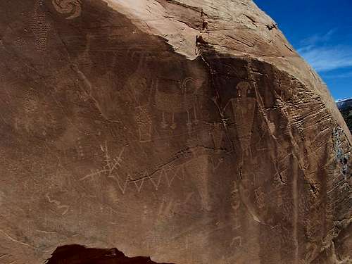 These petroglyphs are located on the lower slopes of South Split Mountain and were carved by the Fremont Culture 1500 to 2500 years ago.