This is a TR from 4 days in the Eagle Cap Wilderness where I took in Minam Lake, Mirror Lake, the west part of the Lakes Basin, Glacier Lake, Eagle Cap, and the East and West Forks Lostine River the week of August 22, 2011. First post, show mercy.
![Eagle Cap at Sunset]() Eagle Cap at sunset with the pink glow courtesy of smoke from a fire in the next drainage west. Taken from camp near the north shore of Mirror Lake.
Eagle Cap at sunset with the pink glow courtesy of smoke from a fire in the next drainage west. Taken from camp near the north shore of Mirror Lake.
This was my second visit to the Wallowas and my first hike there. I hiked in from Two Pan trailhead via the West Fork Lostine River and camped at Minam Lake the first night. Then I continued to Mirror Lake for two more nights. During my days at Mirror Lake I day-hiked in the Lakes Basin, and a 9-mile loop via Glacier Lake and the top of Eagle Cap. I hiked out by the East Fork Lostine River. It's difficult to name the highlight of the trip. This is one of the prettiest lakes regions I've seen, and I grew up in the Colorado Rockies.
![Mirror Lake and Eagle Cap]() Mirror Lake was seldom mirror-like, but is rife with photo opportunities of Eagle Cap reflecting, even abstractly, in its waters. Taken at 8 AM leaving camp on the north shore of Mirror Lake.
Mirror Lake was seldom mirror-like, but is rife with photo opportunities of Eagle Cap reflecting, even abstractly, in its waters. Taken at 8 AM leaving camp on the north shore of Mirror Lake.
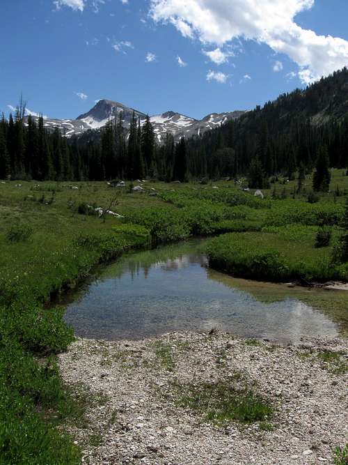
Conditions along this 30+ mile loop were fantastic. The only snow I had to travel across was on the Glacier-Eagle Cap excursion, and it was not extensive or exposed. Glacier Pass and the shores of Glacier Lake were 99.44% snow-free on 24 August 2011. The river valleys were green and lush. Wildflowers were prevalent from approximately 6500 feet up to tree line. I saw lupines just blooming at 8000 feet, along with what I think were paintbrush that had not yet bloomed. Tundra-type flora were still blooming at 9500 feet. Mosquitoes were there, but not bad at all. Horse flies were few except around junctions and outfitter camps.
I heard talk of imposing quotas on Mirror Lake, which would be a major mistake. I camped here two nights in late August with beautiful weather and it was not crowded at all. The lake never had more than 16 parties (about 40 people) on any given night -- including the weekend -- according to the on-site USFS volunteer's careful nightly tally. Mirror Lake is huge, by alpine standards, and there must be 100+ campsites in the immediate lake area (about 200 acres). This is a beautiful spot and it should welcome as many visitors as possible so they, too, will understand why Americans preserve our remaining wilderness areas. If the USFS wants to protect this somewhat fragile mountain ecosystem from overuse, it will ban horses.
Mirror and Minam Lakes
![Minam Lake]() The obligatory shot of Minam Lake from the earthen dam at its north end. The main trail follows the shore on the left. Blue Lake is nestled in a basin behind the ridge to the right.
The obligatory shot of Minam Lake from the earthen dam at its north end. The main trail follows the shore on the left. Blue Lake is nestled in a basin behind the ridge to the right.
If you want absolute solitude and a beautiful lake, consider Minam Lake instead of Mirror. Minam is a big, picturesque lake in a lovely basin at the head of the West Fork valley. I felt completely alone there all evening. The next morning I saw one other person (fishing) and passed one other camp (sleeping) as I traveled the length of the lake on the trail to Carper Pass.
Mirror Lake is the popular choice because most of the campsites are perched on granite benches arranged like bleachers facing the lake with Eagle Cap in full view. Anywhere along the Mirror Lake shore trail, turn uphill and find sandy tent sites, glacier-polished granite dining areas, clumps of shade trees, tiny green basins, springs and streams. The higher you go, the more solitude you'll feel. (There's a nice spring near Sunshine Lake where you can pull water that hasn't flowed across a poop-laden horse trail.) If you're intent on getting away from the so-called crowds at Mirror, camp at Upper Lake or Moccasin Lake, depending upon your day-trip intentions.
![Mirror Lake and Lakes Basin]() Mirror Lake and the Lakes Basin beyond. Taken from Carper Pass, the route between Minam and Mirror Lakes. Eagle Cap is out of the frame to the right.
Mirror Lake and the Lakes Basin beyond. Taken from Carper Pass, the route between Minam and Mirror Lakes. Eagle Cap is out of the frame to the right.
I met up with some friends and we took a loop day hike from Mirror Lake past Moccasin, Crescent, and Douglas lakes plus a few small tarns. This was an easy 5.5-mile walk with very little elevation change and pleasant scenery all the way. We met three other parties, one of which had a half-dozen pack goats.
Glacier Lake and Eagle Cap
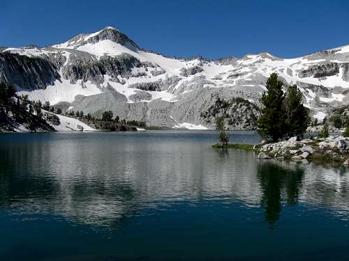
![Glacier Lake and Eagle Cap]() The beauty and size of Glacier Lake is difficult to capture from its shores. This is taken from the spillway at the east end of the lake. There are precious few shade trees in this basin, but the sunshine is what gives it that glorious shimmer.
The beauty and size of Glacier Lake is difficult to capture from its shores. This is taken from the spillway at the east end of the lake. There are precious few shade trees in this basin, but the sunshine is what gives it that glorious shimmer.
The next day's ramble was from Mirror Lake to Glacier Pass, down to Glacier Lake. The hike itself was prettier than I expected as far as the pass, and I saw several possible campsites along the way. At the shore of Glacier Lake was a tiny patch of trail snow, the first. This barren basin is beautiful on a clear day; probably a bit unpleasant in cold or windy weather. There are very few campsites that qualify as being 200 feet from the lake.
![Glacier Lake from Eagle Cap]() The route from Glacier Lake to Eagle Cap summit leaves the inlet marsh of Prospect Lake and angles toward a 9100' saddle, staying high to climber's left to avoid cliffs and larger, steeper snow crossings. From the saddle the remaining 500' is easy walking.
The route from Glacier Lake to Eagle Cap summit leaves the inlet marsh of Prospect Lake and angles toward a 9100' saddle, staying high to climber's left to avoid cliffs and larger, steeper snow crossings. From the saddle the remaining 500' is easy walking.
From Glacier Lake (really Prospect Lake) I scrambled up boulder fields toward Eagle Cap. The route I took (definitely not a trail) is clear from the lake, but instead of going direct I swung left (southward) and skirted an unnamed 9500-foot crag southeast of Eagle Cap to avoid cliffs and a cornice. There are snowfields that must be crossed, but it's easy to choose routes that minimize or eliminate the related risks. I reached a saddle between the two peaks, above the cornice, at 9100 feet. From there it was an easy walk up the ramp through stunted trees to the summit of Eagle Cap. The whole scramble from Prospect to Eagle Cap summit was about 1.5 miles and took 2 hours with a snack break at the saddle.
I returned to Mirror Lake via the Eagle Cap Trail, which had some large patches of snow obscuring the trail. Not having come up this way, I found it tricky to re-locate the trail. Garmin's US Topo GPS maps didn't help, with their usual lax attitude toward accuracy -- in fact, I let it lead me 1/4 mile off trail and into cliffs before I switched to USGS maps (TopoFusion) and got back on track. The Garmin Colorado GPS struggles to display these maps, but they're much more detailed and accurate than anything Garmin sells.
East Fork Lostine River
The final night of my stay had the added feature of a thunderstorm. Luckily, the main energy of the storm seems to have traveled to the south of me. There wasn't much rain, and the lightning was distant enough that its thunder was obscured by the strong and gusty winds that whipped my tent, on and off, half the night.
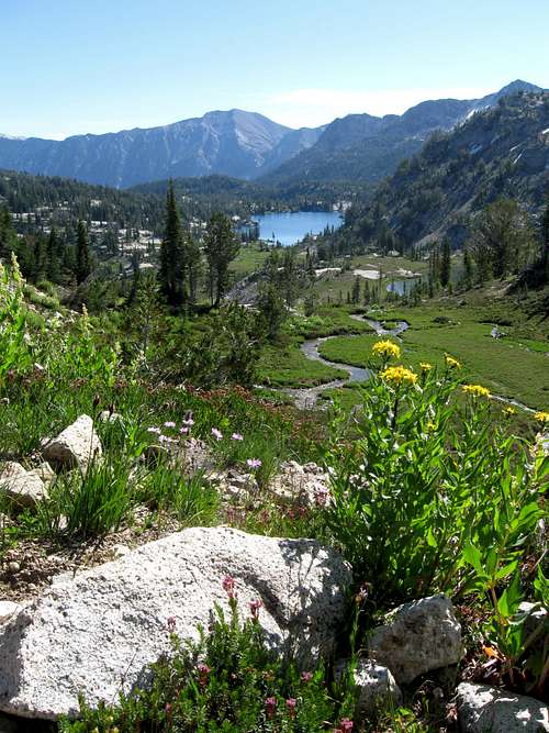
![East Fork Lostine River Trail]() For most of the East Fork Lostine River trail, Eagle Cap is the centerpiece of spectacular and continuously changing mountain scenery. This shot was taken about 2 miles from Mirror Lake.
For most of the East Fork Lostine River trail, Eagle Cap is the centerpiece of spectacular and continuously changing mountain scenery. This shot was taken about 2 miles from Mirror Lake.
For my return to Two Pan trailhead I went via the East Fork Lostine River. What a scenic valley! Every time I turned to look back, Eagle Cap was framed by the green, U-shaped glacial valley and blue skies. The river meanders through deep grass, with lazy bends and sandy pools. The lower valley has plenty of swimming opportunities and campsites.
I noted that there are two parallel trails for a 2-mile portion of this leg, one much nicer than the other. The older, valley trail stays east of the river until crossing it 4 miles from Mirror Lake. The newer, rocky trail appears to have been built exclusively for horse parties, complete with a bridge 2 miles from the lake. The horse trail spends a mile or more stumbling up and down through a burn and side-hilling along boulder fields with occasional views of the valley floor. My advice for people hiking north on the East Fork is simple: Don't cross that bridge when you come to it. (If you're southbound you'll face a crossing at 3.5 miles with a trail to the right that seems to avoid it. Go ahead and cross, or you'll be stuck on the rocky alternate trail for the next 2 miles.)
For planning this trip I referred frequently to this web site of course, plus Douglas Lorain's "Backpacking Oregon" 2nd Edition (2007) and Fred Barstad's "Hiking Oregon's Eagle Cap Wilderness" 2nd Edition (2002) -- in that order -- and found both to be quite accurate. In addition to the usual 7.5 minute USGS maps there is a nice fold-out map of the entire wilderness, available at ranger stations. The USFS Wallowa-Whitman NF map is also indispensable.
Comments
No comments posted yet.