
|
|
Mountain/Rock |
|---|---|
|
|
38.22940°N / 105.7224°W |
|
|
Custer |
|
|
Hiking, Scrambling |
|
|
Spring, Summer, Fall, Winter |
|
|
13205 ft / 4025 m |
|
|
Sangre de Cristo Overview
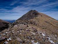
 Eagle Peak & a false summit.
If one has the chance to visit south-central Colorado, one might think that they were in New Mexico, basically anywhere except Colorado. This part of the state is moderate in elevation (on average), hot, arid and dry, the mountains rise substantially from the valley floor and it is fractured by old government land grants and private land dating back as old as 140 years. Fact, Colorado’s first and oldest town lies at the southern terminus of the Sangre de Cristos; the town of San Luis was established in 1851.
For all intensive purposes, the Sangre de Cristo Mountains start near the town of Salida and extend 125 miles south in a 6,000-v-ft. spine to the Colorado-New Mexico border (and actually continues into New Mexico for an additional 90-100 miles). This mountain range, formed by fault-block mountain building (the only kind of this type in Colorado) is exceedingly narrow by Colorado definitions. In some places, this mountain range is only 5-8 miles across.
It is hemmed in by the vast expanse of the San Luis Valley to the west and the arid steppe of the Wet Mountain Valleys to the east. Since the valley floor averages around 7,800-8,00ft, the mountains here which, rise to over 14,000ft, frequently succumb to bad weather and violent storms. Winter in this mountain range can see blizzards and temperatures that would rival the San Juan and Elk Mountain ranges.
 South Ridge
At last estimate there were roughly 180 miles of trail in an area of 186,368 acres. Approaches to peaks, mountains and lakes in this range are often long and hot and where roads do afford one a closer start, expect a very rough and grueling drive. Colorado’s roughest 4x4 road (Lake Como Road) is found in this range.
The Sangre de Cristo (Blood of Christ) Mountains were officially recognized by the Colorado State Legislature in 1993 and have been since labeled as “Wilderness Status”.
A possible origin for this ranges name comes from an old story of a Spanish priest who was shot and killed (and martyred) during the Pueblo revolt in the 17th century by an arrow from local Indian tribes. In his last moments, he looked up and saw the red colours on the high peaks and exclaimed “Sangre de Cristo!” certain that his eternal redemption was at hand.
The alpine lakes in this mountain range are among the best that Colorado has to offer.
Eagle Peak Overview
Eagle Peak lies just north of center within the Sangre de Cristo Range. Because of Forest Service boundaries, Eagle Peak doesn’t actually lie within the Sangre de Cristo Wilderness. It occupies a pocket that extends into the wilderness designation but does come under the jurisdiction of the San Carlos Ranger District.At 13,205ft, Eagle Peak is Colorado’s 482 highest ranked peak. It occupies the end of a long 1.5-mile lower ridge that comes off north from Thirsty Peak. However, since Thirsty Peak is not ranked, its line parent ends up being another mountain called Lakes Peak, which its shared saddle drops to 12,660ft with approximately 545 feet of rise.
 Looking north from Lakes Peak
With the exception of FR #198, the approaches to Eagle Peak are long. Most people either use this rough forest service road and Rainbow Trail to gain higher climes or climb it via its long south ridge from Thirsty Peak.
Indeed, Eagle Peak seems to be quite alone and displaced from all of its neighbors. The south ridge is very noticeable and prominent. The heavily forested Cloverdale Basin to the northwest and the South Lake Creek Basin to the southeast borders it. Because of the immediate gentle terrain to the south, the south ridge provides a convenient way to combo it with other surrounding peaks. Its’ proximate parent is a bi-centennial called Cottonwood Peak A.
Eagle Peak is not a frequently climbed peak despite having some easy access to the north. It’s low elevation and somewhat obscurity from other neighbors like Cottonwood Peak ensures a quiet summit. The views from its’ summit are impressive and it gives a great perspective on the surrounding terrain.
Use Forest Service Maps: Rio Grande NF and San Isabel NF for further information.
Eagle Peak lies inside of the Electric Peak Quadrangle.
Getting There
☯ Rainbow Trail THFrom the small town of Texas Creek located on US-50 (30.7-miles east of Salida) turn south onto CR-69 for 11-miles to the town of Hillside. At Hillside, leave the pavement and turn right onto CR-198 for four miles to the Rainbow Trail Lutheran Camp. The Lake Creek Trailhead is also located here. This road is also known locally as Billy Humble Road. Stay to #198 as many spurs and side roads cross the main road. Once past the Lutheran Camp, the road will get progressively rougher and a couple miles from its end, a truck or jeep will be necessary as it turns into an all out 4x4 road. The 4x4 road will pass Balman Reservoir and end in the upper stretches of Cloverdale Basin. The Cloverdale Mine is located at treeline at the bottom of the west slopes of Eagle Peak. Park anywhere along this stretch and follow trail #752 to the saddle between UN 13,123 and Thirsty Peak. From here, just keep to the ridge heading north off Thirsty Peak towards Eagle Peak. This is the shortest approach and involves less than 2,300ft of elevation gain.
 Area Topo
☯ Valley-View Hot Springs TH
The only downfall to this approach is the sheer length (in excess of 14-miles RT) one has to hike and climb to reach Eagle Peaks summit. The elevation gain on this approach is significant as well, something approaching 5,200ft. However, hiking up Hot Springs Canyon is exceedingly beautiful and on a very decent trail. It does cross the creek multiple times. This route will take you over Cottonwood Peak, UN 13,123 and Thirsty Peak en route to Eagle Peak. It is long with massive elevation gain and long on views.
From the town of Poncha Springs, drive 27.3-miles south on US-285 to the intersection with Co-17. At this turnoff, County Road-GG will start and head due east for approximately 5.8-miles. Continue straight at a turn onto CR-65 for an additional 1.4-miles. The Valley-View Hot Springs Trailhead will come almost immediately after the 90° bend in the road on the left side. It is marked and labeled and shares the same parking area with another trail, the Garner Creek Trail. In the autumn while the Aspens are turning, this approach would be phenomenal.
Camping
The current and accepted practice of responsible camping is to select areas that are more resistant like sandy areas or the forest floor while staying away from more delicate areas like the alpine tundra. Stay away at a minimum of 200ft from water sources to avoid unintentional pollutants and always bury human waste in a cathole at least that distance from water or pack it out. Red Rock
The recommended depth to bury human feces is 6”-8”. At this depth, the decomposition rate is at its highest and most active. There are no official campgrounds at either trailhead other than ‘throwing the tent’ on the ground and making do. This is usually standard practice however.
Keeping that in mind, just use common sense when pitching your tent (IE: not on the trail itself).
Leave No Trace
Red Tape-Miscellaneous
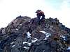 Short class-3
Wilderness Areas set their own regulations in terms of camp sizes, people and pets. The general perimeters are usually between 6-25 people but since Eagle Peak doesn’t actually lie inside of a Wilderness Area, this becomes moot. I mention it because it is surrounded by official wilderness area and it’s just something good to keep in mind.
Some VERY specific Beta on what constitutes Wilderness.
Weather
Click for weather forecast
External Links
• Sangre de Cristo Mountains
• Summitpost Page -by Ryan Schilling
• Trip Report -climber.org
• 14ers.com -Sangre elevation list
• Lists of John -Eagle Peak